Robinson Crusoe Island facts for kids
|
Native name:
Isla Robinson Crusoe
|
|
|---|---|

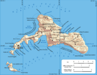
Map of Robinson Crusoe Island
|
|
| Geography | |
| Coordinates | 33°38′29″S 78°50′28″W / 33.64139°S 78.84111°W |
| Type | Shield Volcanoes (last eruption in 1835) |
| Archipelago | Juan Fernández Islands |
| Adjacent bodies of water | Pacific Ocean |
| Area | 47.94 km2 (18.51 sq mi) |
| Highest elevation | 915 m (3,002 ft) |
| Highest point | El Yunque |
| Administration | |
| Region | Valparaíso |
| Province | Valparaíso Province |
| Commune | Juan Fernández Islands |
| Demographics | |
| Population | 843 (2012) |
Robinson Crusoe Island is the largest of three islands in the Juan Fernández archipelago. This group of islands belongs to Chile. The island is also known as Isla Más a Tierra or Aguas Buenas.
More than 800 people live on the island. It is about 672 km (418 mi) from the coast of South America. In 1966, Chile officially renamed it Robinson Crusoe Island. This was done because Alexander Selkirk lived alone there for about four years. Selkirk's real-life adventure might have inspired Daniel Defoe to write his famous book, Robinson Crusoe.
Contents
Exploring Robinson Crusoe Island
Robinson Crusoe Island is a special place in the Pacific Ocean. It is known for its unique nature and interesting history. The island is part of a group called the Juan Fernández Islands.
Where is Robinson Crusoe Island?
This island is located far off the coast of Chile. It is part of the Valparaíso Region in Chile. The island is quite isolated, meaning it is very far from other land.
What is the Island Like?
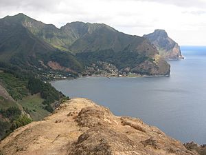
Robinson Crusoe Island was formed by volcanoes. Its highest point is a mountain called El Yunque, which is 915 meters (3,002 feet) tall. The island has beautiful bays and green hills. The main town on the island is called San Juan Bautista. It is located in Cumberland Bay.
The Story of Alexander Selkirk
The island's name comes from a famous story. In the early 1700s, a Scottish sailor named Alexander Selkirk was left alone on this island. He lived there by himself for four years and four months. He survived by using his skills and the island's resources.
How Selkirk Inspired a Book
Selkirk's amazing survival story became well-known. It is believed that his experiences inspired the writer Daniel Defoe. Defoe then wrote the classic novel Robinson Crusoe. This book is about a man who is shipwrecked and lives alone on a deserted island.
Nature and Wildlife
Robinson Crusoe Island is a biosphere reserve. This means it is a special area protected for its unique plants and animals. Many species found here live nowhere else in the world.
Unique Plants and Animals
The island is home to many endemic species. These are plants and animals that are native to only this island. For example, there are special types of ferns and trees. The island also has unique birds and insects. Protecting these species is very important.
Marine Life Around the Island
The waters around Robinson Crusoe Island are full of life. Fishermen often catch spiny lobsters here. These lobsters are a valuable resource for the islanders. The ocean also supports many other marine animals.
History of the Island
The island has a long history beyond Alexander Selkirk. It has been used for different purposes over the centuries.
Early Discoveries
The Juan Fernández Islands were discovered in 1574 by a Spanish sailor named Juan Fernández. The islands were named after him. They were often used as a stop for ships crossing the Pacific Ocean.
A Place for Prisoners
At times, the island was used as a penal colony. This means it was a place where prisoners were sent. It was a remote location, making it hard for prisoners to escape.
World War I History
During World War I, a German warship called the SMS Dresden was in the Pacific. It was eventually cornered by British ships near Robinson Crusoe Island. The crew of the Dresden decided to sink their own ship in Cumberland Bay. This was done to prevent it from being captured by the British.
Life on the Island Today
Today, the island is a small community. The people who live there mainly rely on fishing and tourism.
The Town of San Juan Bautista
Most of the island's population lives in San Juan Bautista. It is a quiet town with a harbor. Visitors can explore the town and learn about the island's history. There is even a statue of Robinson Crusoe in the town.
Protecting the Island
Because of its unique nature, the island is carefully protected. Efforts are made to keep its environment healthy. This helps to preserve the special plants and animals that live there.
Images for kids
-
A fisherman with two spiny lobsters off Robinson Crusoe Island
-
Robinson Crusoe Island bayside view of the town of San Juan Bautista
-
Robinson Crusoe Island statue of Robinson Crusoe in the town of San Juan Bautista
See also
 In Spanish: Isla Robinson Crusoe para niños
 | Precious Adams |
 | Lauren Anderson |
 | Janet Collins |


