
Valparaíso Region facts for kids
Quick facts for kids Valparaíso Region (V Región de Valparaíso) |
|||
| Region of Chile | |||
 Valparaiso from La Sebastiana
|
|||
|
|||
| Country | |||
|---|---|---|---|
| Provinces | Petorca, Los Andes, San Felipe de Aconcagua, Quillota, Quilpué, Valparaíso, San Antonio, Easter Island | ||
| Capital | Valparaíso | ||
| - coordinates | 29°54′S 71°15′W / 29.900°S 71.250°W | ||
| Lowest point | Sea level | ||
| - elevation | 0 m (0 ft) | ||
| Area | 16,396.1 km² (6,331 sq mi) | ||
| Population | 1,825,757 (2015) | ||
| Density | 111 /km² (287 /sq mi) | ||
| Intendant | Gabriel Aldoney Vargas | ||
| ISO 3166-2 | CL-VS | ||


The Valparaíso Region (also known as V Región de Valparaíso) is one of Chile's 15 main administrative divisions. It is a very important part of the country.
The capital of the region is Valparaíso. This city is a major seaport for Chile. Other important cities in the region include Viña del Mar, Quillota, Quilpué, and Villa Alemana.
Contents
History of Valparaíso Region
Valparaíso first became a province in 1842. In 1928, it was briefly part of a new province called Aconcagua. However, by 1936, Valparaíso was made a province again.
Later, in 1974, Chile created its modern regions. That's when Valparaíso officially became one of Chile's regions.
Geography and Natural Features
The Valparaíso region is located in central Chile. It shares borders with several other regions and even another country.
- To the north, it borders the Coquimbo region.
- To the east, it borders Argentina and the Santiago Metropolitan Region.
- To the south, it borders the Santiago Metropolitan Region and the O'Higgins region.
- To the west, it meets the vast Pacific Ocean.
Rivers of the Region
The Valparaíso region has three main rivers that flow through its lands:
- The Petorca River, which is about 120 kilometers (75 miles) long.
- The La Ligua River, measuring around 110 kilometers (68 miles) in length.
- The Aconcagua River, the longest of the three at about 190 kilometers (118 miles).
Population and Major Cities
As of 2015, about 1,825,757 people lived in the Valparaíso region. This means there are about 111 people living in each square kilometer.
The largest city in the region is Viña del Mar. In 2002, it had about 286,931 residents. The capital city, Valparaíso, had about 263,499 people in 2002.
How the Region is Managed
The Valparaíso region is divided into eight smaller areas called provinces. Each province has its own capital city. This helps manage the different parts of the region.
The provinces are:
- Valparaíso Province
- Isla de Pascua Province (Easter Island)
- Los Andes Province
- Petorca Province
- Quillota Province
- San Antonio Province
- San Felipe de Aconcagua Province
- Marga Marga Province
Gallery


Images for kids
-
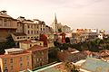
Hills in Valparaiso
-
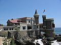
Viña del Mar


See also
| Regions of Chile | |
|---|---|
| Arica y Parinacota | Tarapacá | Antofagasta | Atacama | Coquimbo | Valparaíso | O'Higgins | Maule | Bío Bío | La Araucanía | Los Ríos | Los Lagos | Aysén | Magallanes y la Antártica Chilena | RM Santiago | |
In Spanish: Región de Valparaíso para niños
