
Araucanía Region facts for kids
Quick facts for kids Araucanía Region (IX Región de La Araucanía) |
|||
| Region of Chile | |||
 The Lanín volcano
|
|||
|
|||
| Country | |||
|---|---|---|---|
| Provinces | Cautín, Malleco | ||
| Capital | Temuco | ||
| - coordinates | 38°45′S 72°40′W / 38.750°S 72.667°W | ||
| Lowest point | Pacific Ocean | ||
| - elevation | 0 m (0 ft) | ||
| Area | 31,842.3 km² (12,294 sq mi) | ||
| Population | 995,974 (2016) | ||
| Density | 31 /km² (80 /sq mi) | ||
| Intendant | Nora Barrientos Cárdenas | ||
| ISO 3166-2 | CL-AR | ||


The Araucanía Region is one of Chile's 16 main areas, like a big state or province. It's officially known as the IX Región de La Araucanía. Its biggest city and capital is Temuco.
The name Araucanía means "place where the Araucanians live." The Spanish gave the name "Araucanian" to the Mapuche people. The Mapuche are the native people who have lived in this region for a very long time.
Contents
Exploring the Geography of Araucanía
The Araucanía region covers an area of about 31,842 square kilometers (12,294 square miles). That's a pretty big space!
Where is Araucanía Located?
This region is in the southern part of Chile. It shares borders with other places:
- To the north, it borders the Bío Bío Region.
- To the east, it borders Argentina.
- To the south, it borders the Los Ríos Region.
- To the west, it has a long coastline along the Pacific Ocean.
Rivers and Mountains in Araucanía
The two most important rivers flowing through the region are the Imperial River and the Toltén River. These rivers are important for the local environment and people.
The highest point in the Araucanía region is the Lanín volcano. It stands tall at 3,747 meters (12,293 feet) above sea level. This volcano is located right on the border with Argentina.
People and Population in Araucanía
In 2016, the Araucanía region had a population of about 995,974 people. This means many people live and work in this beautiful part of Chile.
Major Cities in the Region
The largest city in the region is Temuco, which is also its capital. In 2002, Temuco had over 227,000 residents. It's a busy and important center for the region.
Another important city is Angol, which is the capital of one of the region's provinces. In 2002, Angol had about 43,801 people living there.
How Araucanía is Governed
The Araucanía region is divided into two smaller areas called provinces. These provinces help manage the different parts of the region.
Provinces of Araucanía
The two provinces in the Araucanía region are:
Each province has its own capital city. Temuco is the capital of Cautín Province, and Angol is the capital of Malleco Province. These provinces are further divided into smaller areas called comunas, which are like local districts.
Related pages
| Regions of Chile | |
|---|---|
| Arica y Parinacota | Tarapacá | Antofagasta | Atacama | Coquimbo | Valparaíso | O'Higgins | Maule | Bío Bío | La Araucanía | Los Ríos | Los Lagos | Aysén | Magallanes y la Antártica Chilena | RM Santiago | |
Images for kids
-
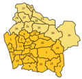
This map shows the different comunas (local districts) within the Araucanía region.

See also
 In Spanish: Región de La Araucanía para niños
