
Arica y Parinacota Region facts for kids
Quick facts for kids Arica and Parinacota (XV Región de Arica y Parinacota) |
|||
| Region of Chile | |||
 Parinacota (volcano) and Chungara lake
|
|||
|
|||
| Country | |||
|---|---|---|---|
| Provinces | Arica, Parinacota | ||
| Capital | Arica | ||
| - coordinates | ACoordinates: Unknown argument format Invalid arguments have been passed to the {{#coordinates:}} function |
||
| Highest point | Parinacota volcano | ||
| - elevation | 6,348 m (20,827 ft) | ||
| Lowest point | Sea level | ||
| - elevation | 0 m (0 ft) | ||
| Area | 16,873.3 km² (6,515 sq mi) | ||
| Population | 239,126 (2015) | ||
| Density | 14 /km² (36 /sq mi) | ||
| Intendant | Gladys Acuña Rosales | ||
| ISO 3166-2 | CL-AP | ||


The Arica and Parinacota Region (Spanish: XV Región de Arica y Parinacota) is a special part of Chile. It's one of Chile's 15 main areas, like a state or province. This region is quite new! It was officially created on October 8, 2007.
Contents
History of the Region
This area was once part of Peru. Chile took control of it after a big conflict called the War of the Pacific in 1883. It officially became part of Chile in 1929.
Geography and Nature
The Arica and Parinacota region is located in the northern part of Chile. It shares borders with Peru to the north and Bolivia to the east. To the south, it borders Chile's Tarapacá region. The Pacific Ocean is to its west.
 |
Tacna (Peru) | La Paz (Bolivia) | |
|
| Pacific Ocean | Oruro (Bolivia) | |||
| Tarapacá region |
This region is part of Chile's "Far North" area, known as Norte Grande. It has many different landscapes. You can find dry deserts, green valleys, and tall Andes mountains. There's also a high plain called the Altiplano to the east.
Mountains and Volcanoes
A narrow strip of land, about 2 kilometers (1.2 miles) wide, runs along the coast. This strip separates the Pacific Ocean from the Andes mountains. The highest point in the region is the Parinacota volcano. It stands at 6,348 meters (20,827 feet) tall. This volcano is located on the border with Bolivia, inside Lauca National Park.
Rivers and Lakes
The region has two main rivers. The Lauca flows into a lake in Bolivia called Coipasa. The Lluta flows into the Pacific Ocean. There's also Lake Chungará, which is very high up. It sits at 4,517 meters (14,820 feet) above sea level. It is one of the highest lakes in the world!
Population and Cities
As of 2015, about 239,126 people lived in the Arica and Parinacota region. This means there were about 14.2 people living in each square kilometer. The biggest city in the region is Arica. It has about 210,936 people living there.

How the Region is Managed
In 2007, the larger Tarapacá region was split into two. This created the Arica and Parinacota region and the current Tarapacá Region. The Arica and Parinacota region is divided into two smaller parts called provinces. These are Arica and Parinacota.

Lagos
Each province is then divided into smaller areas called comunas (communes).
- The Arica Province includes the communes of Arica and Camarones.
- The Parinacota Province includes the communes of Putre and General Lagos.
| Regions of Chile | |
|---|---|
| Arica y Parinacota | Tarapacá | Antofagasta | Atacama | Coquimbo | Valparaíso | O'Higgins | Maule | Bío Bío | La Araucanía | Los Ríos | Los Lagos | Aysén | Magallanes y la Antártica Chilena | RM Santiago | |
Images for kids
-
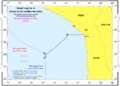
This map shows the sea border between Chile and Peru. It was decided by the International Court of Justice in 2014.


See also
 In Spanish: Región de Arica y Parinacota para niños
