
Lluta River facts for kids
Quick facts for kids Lluta |
|
| River | |
 Valley of the Lluta river
|
|
| Country | Chile |
|---|---|
| Region | Arica y Parinacota |
| Provinces | Parinacota, Arica |
| Comunas | General Lagos, Putre, Arica |
| Tributaries | |
| - left | Allane, Putre, Socoroma, Colpitas |
| City | Putre |
| Confluence | Caracarani and Azufre rivers |
| - location | Parinacota, Arica y Parinacota, Chile |
| - elevation | 3,984 m (13,071 ft) |
| - coordinates | 17°50′21″S 69°42′26″W / 17.83917°S 69.70722°W |
| Mouth | Pacific Ocean |
| - location | Arica, Arica y Parinacota, Chile |
| - elevation | 0 m (0 ft) |
| - coordinates | 18°24′55″S 70°19′35″W / 18.41528°S 70.32639°W |
| Length | 147 km (91 mi) |
| Basin | 3,378 km² (1,304 sq mi) |
| Discharge | |
| - average | 2.35 m³/s (83 cu ft/s) |
| - min | 1.44 m³/s (51 cu ft/s) |
The Lluta River is an important river in the Atacama Desert in Chile. It is the northernmost of Chile's major rivers that begin in the Andes Mountains and flow all the way to the Pacific Ocean. The river runs through the Arica y Parinacota region.
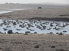
Near the city of Arica, the Lluta River widens into a broad estuary. This area forms a wetland, which is a special habitat for many water birds. These birds live on or near the water.
Contents
River Facts: Length and Area
The Lluta River is about 147 kilometres (91 miles) long. The area of land that drains into the river, called its drainage basin, is about 3,378 square kilometres (1,304 square miles).
Where the Lluta River Starts
The Lluta River begins high up on the Andes mountain slopes. This area is close to the borders of Peru and Bolivia. It starts at a height of about 3,984 metres (13,071 foots) above sea level. This spot is called Humapalca, in the General Lagos area of Parinacota Province, within the Arica y Parinacota Region.
The river is formed when two smaller streams meet:
- Caracarani: This stream starts on the eastern side of the Tacora volcano.
- Azufre: This river is made up of several streams that come from the southwestern side of the Tacora volcano.
The River's Journey to the Sea
For its first 36 kilometres (22 miles), the Lluta River flows towards the southeast. Then, it slowly turns and starts flowing west. As it moves down to lower areas, the river carves out a deep canyon. In some places, this canyon can be as deep as 300 metres (984 foots)!
Near the small village of Socoroma, the river turns directly west. After leaving the canyon, the river starts to get wider. About 70 kilometres (43 miles) from the sea, near the village of Chironta, you can see the first farms.
Finally, the Lluta River flows into the Pacific Ocean. This happens just north of the city of Arica, near the airport in a place called Chacalluta. The Lluta River mostly flows through small villages. The largest town it passes is Putre, which has about 1,977 people (according to the 2022 census).
Lluta River Wetland: A Home for Birds
The area where the Lluta River meets the Pacific Ocean covers more than 171 hectares (423 acres). This coastal wetland is very important for the region. It has lots of vegetation and is home to many water birds. This includes migratory birds that travel long distances.
River's Water Quality
The water in the Lluta River has some natural challenges. It contains high levels of certain natural substances like boron and arsenic. These substances make it difficult for some types of farming to happen along the river.
Main Tributaries
The Lluta River flows through the very dry Atacama Desert. Because of this, it has very few permanent tributaries (smaller rivers or streams that flow into it). Most of the ones it does have join the Lluta from its left side. Some of these include Allane, Putre, Socoroma, and Colpitas.
Gallery
-
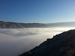
The Lluta valley from the Ruta 11 road
-
Mouth of the Lluta river
-
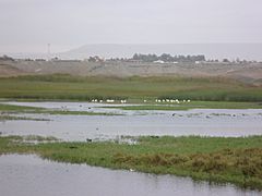
Wetland of the Lluta river, Arica
-
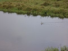
A water bird in the Lluta river wetland


.JPG)
.JPG)
Related pages
See also
 In Spanish: Río Lluta para niños
