
Arica facts for kids
Quick facts for kids
Arica
|
||||||
|---|---|---|---|---|---|---|

Clockwise, from top: Morro de Arica; Arica Cathedral; station of the Arica-La Paz railway; Casa de la Cultura de Arica; Presencias tutelares sculptures; Museum of History and Weapon; Plaza Colón
|
||||||
|
||||||
| Nickname(s):
"City of the eternal spring"
|
||||||
| Country | Chile | |||||
| Region | Arica y Parinacota | |||||
| Province | Arica | |||||
| Founded | 1541 | |||||
| Government | ||||||
| • Type | Municipality | |||||
| Area | ||||||
| • Total | 4,799.4 km2 (1,853.1 sq mi) | |||||
| Area rank | Arica | |||||
| Elevation | 2 m (7 ft) | |||||
| Population
(2017)
|
||||||
| • Total | 222,619 | |||||
| • Density | 46.3848/km2 (120.1360/sq mi) | |||||
| Demonym(s) | Arican, aricano (M), aricana (F) | |||||
| Sex | ||||||
| • Male | 110,115 | |||||
| • Female | 112,504 | |||||
| Time zone | UTC−04:00 (CLT) | |||||
| • Summer (DST) | UTC−03:00 (CLST) | |||||
| Postal code |
1000000
|
|||||
| País | +56 58 | |||||
| Climate | BWh | |||||
| Website | Official website: http://www.municipalidaddearica.cl/ | |||||


Arica is a city and a port in northern Chile. It is the northernmost city in Chile. Arica is located only 18 kilometers (11 miles) south of the border with Peru.
This city is the capital of both the Arica Province and the Arica y Parinacota Region. Arica sits where the western coast of South America bends, a spot known as the Arica Bend. Two valleys, Azapa and Lluta, meet here. These valleys are important for growing citrus fruits and olives that are sent to other places.
Arica is a very important port for a large area of South America that is not near the coast. It acts as a free port for Bolivia, helping with much of that country's trade. It is also where an oil pipeline from Oruro, Bolivia, ends. The city's location is great because it is next to the Pan-American Highway. It is also connected to Tacna in Peru and La Paz in Bolivia by train. Plus, it has an international airport.
Arica has a very dry climate, meaning it gets almost no rain. But cool winds from the nearby Humboldt Current keep the weather mild. Because of its pleasant weather, Arica is known as the "city of the eternal spring" in Chile. Its beaches are also popular with people from Bolivia. Arica was an important port even when Spain ruled. Chile took the city from Peru in 1880 during the War of the Pacific. Peru officially recognized Arica as part of Chile in 1929. Many African Chileans live in Arica or have family roots there.
Contents
Discover Arica's Past
Archaeological finds show that different native groups lived in Arica as far back as 10,000 years ago. These people were the first known culture to mummify their dead. They did this 2,000 years before the Egyptians! Their mummies have been found as recently as 2004, sometimes buried less than a meter (3 feet) deep.
Colonial Times in Arica
Spaniards first settled the area in 1541. This was led by Captain Lucas Martinez de Begazo. In 1570, the area was given a grand name: "La Muy Ilustre y Real Ciudad San Marcos de Arica." This means "the very illustrious and royal city of San Marcos of Arica."
By 1545, Arica became the main port for sending out silver from Bolivia. This silver came from Potosí, which had the world's largest silver mine at the time. Arica was a very important port for the Spanish Empire. Because of its great wealth, Arica was often attacked by pirates and buccaneers. Famous ones like Francis Drake and Thomas Cavendish looted the city.
Arica as Part of Peru (1821–1880)
After Spain's rule ended, Arica became part of the new country of Peru in 1821. Peru's Constitution of 1823 made Arica a province. In 1855, Peru opened the Arica-Tacna railroad, which was 53 kilometers (33 miles) long. This was one of the first railroads in Latin America. The train line is still used today.
.JPG)
A huge earthquake hit near the city on August 13, 1868. It was very powerful, estimated between 8.0 and 9.0 magnitude. Some guess that 25,000 to 70,000 people died. However, Arica's population was less than 3,000 people then. Other estimates say around 300 people died. The earthquake also caused a tsunami that reached places like Hawaii, Japan, and New Zealand. Arica is very close to a deep ocean trench. This means the city can have very strong earthquakes.
Becoming Part of Chile (1880–1929)

Chilean forces took control of the region after the War of the Pacific. The Treaty of Ancón in 1883 officially gave the region to Chile. Later, in 1929, the Treaty of Lima returned Tacna to Peru. But Arica remained a part of Chile.
Modern Arica (1929–Present)
In 1958, the Chilean Government created the "Junta de Adelanto de Arica." This group offered tax breaks to encourage new businesses. Many car companies, like Citroën and Ford, opened factories in Arica. The city also became a tax-free zone and got a casino.
In 1975, Chile changed its economic policies. The "Junta de Adelanto de Arica" was then closed down.
The Arica and Parinacota Region was officially created on October 8, 2007. This happened under a new law signed by President Michelle Bachelet in Arica.
Arica's People

In 2017, Arica had 222,619 people living there. This included 110,115 men and 112,504 women. The population grew by 20% between 2002 and 2017. Most of the people in the Arica y Parinacota region live in Arica.
Arica's population is made up of many different groups. Some have lived there for a very long time. The oldest groups are native Amerindians, like the Aymara. They have been in the region for thousands of years. Then there are groups from the colonial era. These include mestizos (people of mixed Spanish and Amerindian background) and criollos (white people of Spanish origin). There are also people of African descent whose ancestors were slaves in colonial times. Later, in the 1890s, early Chinese Chileans arrived as miners and railway workers.
More recently, other Chileans from different parts of the country have moved to Arica. Many Europeans also arrived in the 1900s. These included more Spaniards, Italians, Greeks, British, and French people.
Some people in Arica, especially the native Amerindians and those of African descent, share cultural ties with people in nearby Peru and Bolivia.
The main city area of Arica has 175,441 residents. The city is growing outwards into the desert and towards the Peru-Chile border. The Azapa Valley now has farming all year round. This is thanks to better irrigation and ways to transport its products.
Small villages in the Arica commune include Villa Frontera and San Miguel de Azapa. Some tiny settlements are Poconchile, Molinas, Sora, Las Maitas, and Caleta Vitor.
Arica became famous in 1970 because of a spiritual teacher named Oscar Ichazo. He held a 10-month training program there. The Arica School, based in the United States, has influenced many people worldwide.
Arica's Economy
Arica is the economic center of its region. It is a huge place for trade and shipping. It is also very important for Bolivia to access the sea.
Cool Places to See in Arica
The Morro de Arica is a tall, almost straight-up rock formation. It is about 139 meters (456 feet) above sea level. This hill was the last defense for Peruvian soldiers in the city. Chilean troops attacked and captured it on June 7, 1880. This was during the War of the Pacific.
Near the city center is the Azapa Valley. This is an oasis where vegetables and famous Azapa olives are grown. Arica is also an important port for Chilean ore. The warm weather, low humidity, and beaches make Arica a popular place for tourists. It is also a center for Chilean train networks that connect to Bolivia. For air travel, the Chacalluta International Airport serves the region.
Arica has strong connections with the city of Tacna in Perú. Many people cross the border every day between the two cities. This is partly because services like dentists and doctors are cheaper in Peru. Arica is connected to both Tacna and La Paz by separate train lines.
-
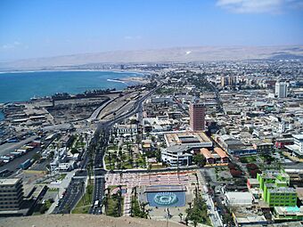
The city view from Morro de Arica
-
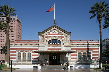
Arica's Customs Office, built by the Peruvian Government after the 1868 earthquake.


Arica's Climate
Arica has a hot desert climate. This means it is very dry. Unlike many other desert cities, Arica rarely has extreme hot or cold temperatures. It is also often cloudy. Arica is known as the driest inhabited place on Earth. It gets only about 0.76 millimeters (0.03 inches) of rain each year. This is measured at the airport weather station.
| Climate data for Arica (1991–2020, extremes 1955–present) | |||||||||||||
|---|---|---|---|---|---|---|---|---|---|---|---|---|---|
| Month | Jan | Feb | Mar | Apr | May | Jun | Jul | Aug | Sep | Oct | Nov | Dec | Year |
| Record high °C (°F) | 33.0 (91.4) |
35.2 (95.4) |
34.2 (93.6) |
31.3 (88.3) |
29.4 (84.9) |
27.8 (82.0) |
27.9 (82.2) |
24.8 (76.6) |
30.6 (87.1) |
27.0 (80.6) |
30.2 (86.4) |
30.2 (86.4) |
35.2 (95.4) |
| Mean daily maximum °C (°F) | 25.7 (78.3) |
26.2 (79.2) |
25.4 (77.7) |
23.5 (74.3) |
21.3 (70.3) |
19.3 (66.7) |
18.2 (64.8) |
18.2 (64.8) |
18.9 (66.0) |
20.4 (68.7) |
22.2 (72.0) |
24.0 (75.2) |
21.9 (71.4) |
| Daily mean °C (°F) | 22.5 (72.5) |
22.8 (73.0) |
22.0 (71.6) |
20.2 (68.4) |
18.5 (65.3) |
17.1 (62.8) |
16.1 (61.0) |
16.1 (61.0) |
16.6 (61.9) |
17.8 (64.0) |
19.3 (66.7) |
20.9 (69.6) |
19.2 (66.6) |
| Mean daily minimum °C (°F) | 19.9 (67.8) |
20.2 (68.4) |
19.3 (66.7) |
17.4 (63.3) |
16.0 (60.8) |
15.2 (59.4) |
14.6 (58.3) |
14.8 (58.6) |
15.2 (59.4) |
16.1 (61.0) |
17.2 (63.0) |
18.4 (65.1) |
17.0 (62.6) |
| Record low °C (°F) | 7.5 (45.5) |
8.0 (46.4) |
10.2 (50.4) |
8.4 (47.1) |
6.8 (44.2) |
5.8 (42.4) |
6.2 (43.2) |
6.2 (43.2) |
6.9 (44.4) |
5.6 (42.1) |
7.7 (45.9) |
10.7 (51.3) |
5.6 (42.1) |
| Average precipitation mm (inches) | 0.4 (0.02) |
0.3 (0.01) |
0.3 (0.01) |
0.0 (0.0) |
0.1 (0.00) |
0.2 (0.01) |
0.5 (0.02) |
0.1 (0.00) |
0.3 (0.01) |
0.0 (0.0) |
0.0 (0.0) |
0.1 (0.00) |
2.3 (0.09) |
| Average precipitation days (≥ 1.0 mm) | 0.1 | 0.1 | 0.2 | 0.0 | 0.0 | 0.1 | 0.1 | 0.0 | 0.1 | 0.0 | 0.0 | 0.0 | 0.8 |
| Average relative humidity (%) | 66 | 66 | 67 | 69 | 71 | 72 | 72 | 73 | 72 | 70 | 68 | 66 | 69 |
| Mean monthly sunshine hours | 258.8 | 257.9 | 272.8 | 228.5 | 186.0 | 131.8 | 119.4 | 123.1 | 146.7 | 196.0 | 229.5 | 257.9 | 2,408.4 |
| Source 1: Dirección Meteorológica de Chile | |||||||||||||
| Source 2: NOAA (precipitation days 1991–2020) | |||||||||||||
How Arica is Governed
Arica is a commune, which is a local government area in Chile. It is managed by a municipal council. The head of the council is the alcalde, who is like a mayor. The alcalde is chosen by voters every four years. The alcalde from 2008 to 2012 was Waldo Sankán Martínez.
In Chile's elections, Arica is part of the 1st electoral district. This district includes the whole Arica and Parinacota Region. Arica is represented in the Chamber of Deputies by Mr. Vlado Mirosevic and Mr. Luis Rocaful. In the Senate, Arica is represented by José Miguel Insulza and José Durana.
Sports in Arica
Arica was one of four cities that hosted the 1962 FIFA World Cup (a big soccer tournament). It also hosted a Rip Curl Pro Search surfing event in 2007.
Every year, Arica hosts a world tour event for bodyboarding. This takes place at a famous surf spot called "el flops." This event has been happening since 2004.
Fun Places to Visit in Arica
Arica has many interesting places for visitors:
- Morro de Arica: This is the tall hill that stands over the city. It offers amazing views of Arica.
- Catedral de San Marcos de Arica: This beautiful church was designed by Gustave Eiffel (who also designed the Eiffel Tower!). It was built in the 1870s.
- Plaza Colón: This is the main public square in the city. People gather here for celebrations, fun, or just to hang out.
Other places to see include the former Governor's house and the Former Arica Custom House. You can also visit the Arica-La Paz railway station. There's the Archaeological and Anthropological Museum of San Miguel de Azapa. The Sea and Historical Arms Museum and the Casino de Arica are also popular.
Arica's Beaches
Arica has more than 20 kilometers (12 miles) of beaches. Many of them are known for great surfing. These beaches are special because of their location.
From north to south, some of the beaches are Las Machas, Chinchorro, del Alacrán, El Laucho, La Lisera, Brava, Arenillas Negras, La Capilla, Corazones, and La Liserilla.
Other Tourist Spots

- Chungará Lake: Arica is the main way to get to this lake. It is the 29th highest lake in the world. It sits about 4517 meters (14,820 feet) above sea level. The lake is inside the Lauca National Park.
- Pucará de Copaquilla: This ancient fort is about 3,000 meters (9,842 feet) above sea level. It dates back to the 12th century. It has been declared a National Monument. The fort is on a hill and has a double stone wall for defense. From here, you can see old ruins and streams.
- Termas de Jurasi: These are hot springs located southeast of Putre. The underground water here is over 40°C (104°F). People believe it has healing properties.
- Surf: Arica is famous worldwide for surfing. The wave called "El Gringo" hosts world championships for surfing and bodyboarding every year. In 2007, Arica was part of the ASP world tour. Other stops on this tour include Hawaii and Tahiti.
Getting Around Arica
.jpg)
Passenger train services on the Arica–La Paz railway stopped in 1996. However, there are plans to restart services from Arica for tourists and for cargo.
In 2011, Chile planned to make the Port of Arica privately owned. Bolivia was against this, as Arica is its main seaport.
Chacalluta International Airport is Arica's main airport. It is 18.5 kilometers (11.5 miles) north of the city. Airlines like LATAM Chile and Sky Airline have flights to other Chilean airports from here.
See also
 In Spanish: Arica para niños
