
Tacna facts for kids
Quick facts for kids
Tacna
Takana
San Pedro de Tacna
|
|||
|---|---|---|---|

Clockwise from top: Alto de la Alianza, the Coliseo Cerrado Perú, Municipal Hall, Basadre Stadium, Cathedral and railway museum
|
|||
|
|||
| Nickname(s):
La Ciudad Heroica
(The Heroic City) |
|||

Tacna
Location in Department of Tacna

Tacna
Location in Peru
|
|||
| Country | |||
| Region | Tacna | ||
| Province | Tacna | ||
| District | Tacna | ||
| Established | 29 June 1541 | ||
| Area | |||
| • Total | 14,766.63 km2 (5,701.43 sq mi) | ||
| Elevation | 552 m (1,811 ft) | ||
| Population
(2017)
|
|||
| • Total | 286,240 | ||
| • Estimate
(2015)
|
293,116 | ||
| • Density | 19.3842/km2 (50.2050/sq mi) | ||
| Demonym(s) | Tacneño/a | ||
| Time zone | UTC-5 (PET) | ||
| UBIGEO |
23000
|
||
| Area code | 52 | ||

Tacna, also known as San Pedro de Tacna, is a lively city in southern Peru. It is the capital of the Tacna Region. The city is very active in trade and business. It is located about 35 kilometers (22 miles) north of the border with Chile. Tacna is near the Pacific Ocean and sits in the valley of the Caplina River. It is the tenth largest city in Peru by population.
Tacna is famous for its strong sense of patriotism. Many monuments and streets are named after heroes who fought for Peru's independence (1821–1824). They also honor heroes from the War of the Pacific (1879–1883). People from Tacna are called tacneños in Spanish.
Contents
History of Tacna
Tacna played a big role in Peru's fight for independence from Spain. In 1811, Francisco Antonio de Zela started a rebellion here. Because of its brave actions, Tacna was declared the "Heroic City" in 1828 by President José de La Mar. Its full heroic name is La Heroica Ciudad de San Pedro de Tacna.
For a short time, from 1836 to 1839, Tacna was the capital of the Peru-Bolivian Confederation.
Tacna was once known for its mining, especially for sodium nitrate. This brought many immigrants from Italy to the city. Today, many people in Tacna still have Italian family names. This time of wealth ended when the War of the Pacific began.
During the war, many soldiers gathered in Tacna. The city lost many people to sickness before Chile captured it in May 1880. This happened after the allied army was defeated in the Battle of Tacna.
Tacna Under Chilean Rule
After the war, Tacna and nearby Arica were controlled by Chile. This period is called the cautiverio in Peruvian history, meaning "captivity." In 1883, the Treaty of Ancón ended the war. This treaty said that Chile would manage Tacna and Arica for ten years. After that, people would vote to decide if the region would belong to Peru or Chile.
However, Peru and Chile could not agree on who should vote. Chile tried to make the local people feel more Chilean. But Peruvian nationalists worked hard to keep their Peruvian identity strong. Because of this, the vote never happened.
The city of Tacna was formally set up as a Chilean commune in 1891. It had four main areas: El Callao, San Ramón, El Mercado, and El Alto de Lima.
In 1907, about 10,593 people lived in Tacna. Famous people like Jorge Basadre and Salvador Allende lived there during this time.
In 1928, the commune of Tacna was reorganized into three areas: Intendencia, Comercio, and Pocollay.
Tacna Returns to Peru
Finally, in 1929, the Treaty of Lima was signed. Chile kept Arica, but Tacna was given back to Peru. Peru also received money and other agreements. On August 28, 1929, Tacna officially became part of Peru again. This was a very important day for the city.
Today, Tacna is a busy commercial city. Many people from the Puno Region have moved there. Its economy relies on trade with northern Chile, especially with Arica and Iquique. Tacna is a duty-free zone, which means goods can be bought and sold without extra taxes. This has made it a major business center in southern Peru. The city has one of the largest markets for imported goods from Japan and China, as well as traditional Peruvian crafts.
Geography and Climate
The area around Tacna is mostly desert. There are a few green, fertile spots near the mountains. The Caplina River is one of the few rivers that flows through the province.
Tacna's Climate
Tacna has a desert climate. This means it is very dry and sunny most of the year.
| Climate data for Tacna (Jorge Basadre), elevation 560 m (1,840 ft), (1991–2020 normals, extremes 1949–present) | |||||||||||||
|---|---|---|---|---|---|---|---|---|---|---|---|---|---|
| Month | Jan | Feb | Mar | Apr | May | Jun | Jul | Aug | Sep | Oct | Nov | Dec | Year |
| Record high °C (°F) | 33.0 (91.4) |
33.2 (91.8) |
33.8 (92.8) |
31.0 (87.8) |
31.3 (88.3) |
30.1 (86.2) |
31.6 (88.9) |
28.0 (82.4) |
27.8 (82.0) |
29.2 (84.6) |
30.0 (86.0) |
30.0 (86.0) |
33.8 (92.8) |
| Mean daily maximum °C (°F) | 27.8 (82.0) |
28.5 (83.3) |
27.4 (81.3) |
24.8 (76.6) |
22.1 (71.8) |
19.9 (67.8) |
19.0 (66.2) |
19.6 (67.3) |
20.9 (69.6) |
22.9 (73.2) |
24.6 (76.3) |
26.3 (79.3) |
23.7 (74.6) |
| Mean daily minimum °C (°F) | 17.2 (63.0) |
17.7 (63.9) |
16.7 (62.1) |
14.9 (58.8) |
12.9 (55.2) |
11.2 (52.2) |
10.4 (50.7) |
10.6 (51.1) |
11.4 (52.5) |
12.6 (54.7) |
14.1 (57.4) |
15.6 (60.1) |
13.8 (56.8) |
| Record low °C (°F) | 7.6 (45.7) |
10.0 (50.0) |
6.1 (43.0) |
3.9 (39.0) |
3.9 (39.0) |
0.4 (32.7) |
0.0 (32.0) |
3.9 (39.0) |
3.9 (39.0) |
6.1 (43.0) |
7.2 (45.0) |
7.2 (45.0) |
0.0 (32.0) |
| Average precipitation mm (inches) | 3.5 (0.14) |
2.3 (0.09) |
0.8 (0.03) |
0.2 (0.01) |
0.5 (0.02) |
2.0 (0.08) |
3.9 (0.15) |
4.2 (0.17) |
4.0 (0.16) |
1.4 (0.06) |
0.9 (0.04) |
1.3 (0.05) |
25 (1) |
| Average precipitation days (≥ 1.0 mm) | 0.0 | 0.2 | 0.0 | 0.0 | 0.0 | 0.3 | 0.9 | 1.2 | 0.3 | 0.4 | 0.0 | 0.0 | 3.4 |
| Average relative humidity (%) | 66 | 65 | 67 | 72 | 76 | 78 | 77 | 78 | 75 | 74 | 71 | 68 | 72 |
| Mean monthly sunshine hours | 217.0 | 197.8 | 229.4 | 222.0 | 176.7 | 162.0 | 173.6 | 189.1 | 147.0 | 232.5 | 243.0 | 248.0 | 2,438.1 |
| Mean daily sunshine hours | 7.0 | 7.0 | 7.4 | 7.4 | 5.7 | 5.4 | 5.6 | 6.1 | 4.9 | 7.5 | 8.1 | 8.0 | 6.7 |
| Source 1: National Meteorology and Hydrology Service of Peru | |||||||||||||
| Source 2: Meteo Climat (record highs and lows)Deutscher Wetterdienst (precipitation days 1970–1990, humidity 1951–1969, and sun 1930–1937) | |||||||||||||
Transportation in Tacna
Tacna has several ways to get around and connect with other places.
Rail Travel
Tacna used to have a railway line that crossed the border to Arica, Chile. This line closed in 2012, but there are plans to open it again.
The city is also home to the National Railway Museum of Peru. You can learn about the history of trains there.
Air Travel
Tacna has an airport called Crnl. FAP. Carlos Ciriani Santa Rosa International Airport. From here, you can take flights to Arequipa and Lima.
Road Travel
Peru Highway 1 passes through Tacna. This road goes south to Arica in Chile and north to Moquegua in Peru.
Fun Places to Visit in Tacna
Tacna has many interesting monuments and places to see.
- The arch of the Alto de la Alianza is a famous monument.
- The Tacna Parabolic Arch is another important landmark.
- You can visit the beautiful neo-renaissance Cathedral.
- The Courthouse is also an impressive building.
- Take a stroll along the Alameda Bolognesi.
- Explore the Toquepala Caves, where archaeologists found some of the oldest human remains in Peru.
Tacna's Festivities
Tacna celebrates several important events throughout the year.
- The most important celebration is Semana de Tacna (Tacna Week). It happens from August 25 to 30.
- On August 28, there is a special event called Paseo de la Bandera. A large Peruvian flag is carried through the city. This celebrates the day Tacna became part of Peru again. It's one of the most patriotic events in the whole country. This tradition started in 1901 when brave tacneños showed Peruvian flags even though Chilean authorities had forbidden it.
- During Tacna Week, there is also a fair that shows off local farming and industry.
- In September, the festival of the Señor de Locumba takes place. Thousands of people from all over the world come to celebrate this religious event.
Images for kids
-
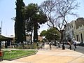
Main square in San Martin area
-
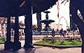
Arco Parabólico, Pileta and Glorieta de Tacna, located in the Av. San Martín
-

Coctel Mercado Viejo


See also
 In Spanish: Tacna para niños
