
Arequipa facts for kids
Quick facts for kids
Arequipa
|
|||
|---|---|---|---|
|
Region capital
|
|||
| City of Arequipa | |||
|
Cathedral of Arequipa
Monastery of Santa Catalina
Misti Volcano
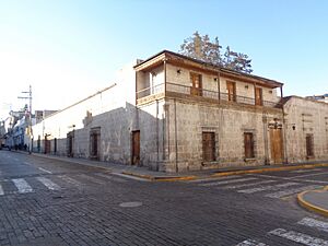
Street in Arequipa
Church of La Compañía
Skyline of Arequipa from Mirador de Yanahuara
|
|||
|
|||
| Nickname(s):
La Ciudad Blanca (The White City), León del Sur (Lion of the South)
|
|||
| Anthem: Himno Arequipeño | |||

Arequipa
Location in Peru
|
|||
| Country | Peru | ||
| Region | Arequipa | ||
| Province | Arequipa | ||
| Established | 15 August 1540 | ||
| Founded by | Garcí Manuel de Carbajal | ||
| Area | |||
| • Region capital | 69 km2 (27 sq mi) | ||
| • Metro | 2,923.53 km2 (1,128.78 sq mi) | ||
| Elevation | 2,335 m (7,661 ft) | ||
| Population
(2017)
|
|||
| • Region capital | 1,008,290 | ||
| • Estimate
(2022)
|
1,226,404 | ||
| • Rank | 2nd in Peru | ||
| • Density | 14,610/km2 (37,850/sq mi) | ||
| • Metro | 1,034,736 | ||
| Demonym(s) | Arequipenian (Spanish: arequipeño- a) Mistiano-a | ||
| GDP (PPP, constant 2015 values) | |||
| • Year | 2023 | ||
| • Total | $12.8 billion | ||
| Demographics | |||
| • Ethnic groups |
|
||
| Time zone | UTC-5 (PET) | ||
| • Summer (DST) | UTC−5 (PET) | ||
| Postal code |
040
|
||
| Area code(s) | 54 | ||
| Official name: Historical Centre of the City of Arequipa | |||
| Type: | Cultural | ||
| Criteria: | i, iv | ||
| Designated: | 2000 (24th session) | ||
| Reference #: | 1016 | ||
| Region: | Latin America and Caribbean | ||


Arequipa (Spanish pronunciation: [aɾeˈkipa]), also known as Ciudad Blanca (meaning "White City") and León del Sur ("Lion of the South"), is a major city in Peru. It is the capital of the Arequipa region and province. Arequipa is Peru's second-largest city after Lima, with over 1.2 million people living in its urban area.
The city is famous for its beautiful buildings made from white volcanic stone. It is a very important cultural and economic center in Peru. Arequipa's historic center is so special that UNESCO named it a World Heritage Site.
Arequipa is also a big industrial and business hub in Peru. It is known for making textiles from camelid wool. The city has strong trade connections with nearby countries like Chile, Bolivia, and Brazil.
The city was founded on August 15, 1540, by Garcí Manuel de Carbajal. It was first called "Beautiful Villa of Our Lady of the Assumption." Later, King Carlos V ordered it to be called the "City of Arequipa." During the time Peru was a Spanish colony, Arequipa became very important for its economy. It was also known for being very loyal to the Spanish Crown.
Contents
What's in a Name?
The name Arequipa might come from the Aymara language. Some historians believe it comes from ari qhipa, which means "(place) behind the peak." This would refer to the nearby Misti volcano.
Another popular story says that when the Inca ruler Mayta Cápac visited the Chili River valley, his people asked to stay because it was so beautiful. He replied in Quechua, "Ari, qhipay," meaning "Yes, stay." The Spanish later heard this as "Arequipa."
City Symbols
The Flag
Arequipa's flag is crimson (a deep red color). Historians believe this color has a royal origin, meaning it was linked to the Spanish royal family. This color is also used by many local sports teams.
The Coat of Arms
On December 22, 1540, King Charles I of Spain officially made Arequipa a city. He gave it a special coat of arms. This coat of arms shows a mythical animal holding a banner with "Karlos V" or "Del Rey" written on it.
The Anthem
The city's anthem is called Fourth Centenary Anthem. The words and music were created by Emilio Pardo Valle and Aurelio Diaz Espinoza. They won a contest in 1939 to create a new song for the city. This anthem is now sung at all important city events.
Arequipa's Story
Early History
Long ago, the first people in the Arequipa area were nomads. They moved around, fishing and hunting for food. Later, they learned to farm and raise llamas, settling down in villages. They built terraces to grow crops along the Chili River. Tribes like the Yarabaya and Chimbe lived where Arequipa is today.
When the Inca ruler Mayta Cápac arrived, he didn't build new cities. Instead, he moved people around to help control his lands. One story says that around 1170, another Inca ruler, Huayna Capac, stopped in the Chili River valley and said, "Let's stay here." Lands were then given to 3,000 families who started communities like Yanahuara and Cayma. These are now districts within Arequipa.
Colonial Times
On August 15, 1540, Spanish lieutenant Garcí Manuel de Carbajal officially founded the city. It was first called "Villa de la Asunción de Nuestra Señora del Valle Hermoso de Arequipa." King Charles V later gave it the title of "city" on September 22, 1541.
Arequipa quickly became one of the most important cities in the Viceroyalty of Peru (the Spanish colony). It was second only to the capital, Lima. The city council was set up to choose mayors and other leaders. The Basilica Cathedral of Arequipa began construction in 1544. It was rebuilt after an earthquake in 1583 and finished in 1950.
Arequipa was known for being very loyal to the Spanish Crown. This loyalty was called "fidelismo." Even during rebellions by local people, Arequipa stayed loyal to Spain. For its services, King Charles IV gave the city the title of "Most Faithful" in 1895.
Independence
Arequipa remained under Spanish control until the Battle of Ayacucho in 1824. This battle was a key moment in Peru's fight for independence.
The Republic Era
19th Century Changes
After Peru became independent, Arequipa became a department in 1822. The city was a strong opponent of Simón Bolívar's ideas for a lifelong presidency. Important people from Arequipa spoke out against it. During this time, the National University of San Agustín was founded in 1827.
Arequipa's location was perfect for trade, especially for silver and wool. This helped the city become a major center for business and industry. It also became a place where many important political leaders and movements started.
In 1835, President Luis José de Orbegoso moved the government from Lima to Arequipa. This led to conflicts with other leaders. Arequipa was also the site of many uprisings and military takeovers.
.jpg)

In 1882, during the War of the Pacific, President Lizardo Montero Flores declared Arequipa the capital of Peru. This lasted until Lima was no longer occupied in 1823. However, a local uprising in 1883 overthrew Montero's government. Chilean troops then occupied Arequipa for a short time.
20th Century Growth
The 20th century brought many improvements to Arequipa. The Southern Railroad connected the city to the port of Mollendo in 1871 and to Cuzco in 1876. The first telegraph system arrived in 1908. In 1914, the city got its first drinking water system. Rodríguez Ballón International Airport opened in 1940.
Arequipa also saw political changes. In 1930, Luis Miguel Sánchez Cerro took control, leading to the departure of President Augusto B. Leguía. Later, in 1948, General Manuel A. Odrían formed a new government. Arequipa was also a center for protests against these changes, especially in 1950 and 1955.
21st Century Today

In 2000, the historic center of Arequipa was named a World Heritage Site by UNESCO. In 2001, a strong earthquake damaged some historic buildings. This led to new safety measures to protect the city's history.
Around the 2010s, Arequipa's economy grew a lot, partly because of its mining industry. The city is near large copper reserves. Arequipa is also working on improving its water management and city planning. The city's transport system has been updated, with new buses and a focus on electric vehicles.
Geography and Climate
Where is Arequipa?
Arequipa is located high up, about 2,328 meters (7,638 feet) above sea level. The lowest part of the city is at 2,041 meters (6,696 feet), and the highest is at 2,810 meters (9,219 feet).
The Chili River flows through the middle of the city. To the north and east are the Andes Mountains. To the south and west are smaller mountain ranges. Arequipa's valley connects the coast and the highlands of southern Peru.
Three volcanoes stand tall over the city: Misti and the extinct volcanoes Pichu Pichu and Chachani. The western slopes of the Andes have thick layers of volcanic rock.
Arequipa's Weather

Arequipa has a mostly dry climate, especially in winter, autumn, and spring. It gets very little rain, like a desert. The city enjoys about 300 sunny days each year! Temperatures usually stay between 5°C (41°F) and 25°C (77°F).
The rainy season is from December to March, with some clouds and light rain. In winter (June and July), temperatures can drop to about 6°C (43°F). The air is usually not very humid, averaging 46%.
City Layout


When the Spanish founded Arequipa in 1540, they planned it like a checkerboard. It had 56 blocks, each about 111 meters (365 feet) long. Over time, some large buildings like the Santa Catalina Convent took up entire blocks.
The city grew outwards, taking over the countryside. New roads were built to connect the old center with newer neighborhoods. Shantytowns also appeared as more people moved to the city. Important buildings like the San Camilo marketplace and Goyeneche Hospital were built in the early 1900s. The city also added theaters, a hotel, and a public library.
In the late 1950s, Arequipa grew very fast, especially in its outer areas. Factories moved away from the city center to industrial zones. The city center then became more focused on tourism and business.

City Districts
The Arequipa metropolitan area has 19 districts. These districts cover a total area of about 305,798 acres (1,237 square kilometers). About 10,142 acres (41 square kilometers) of this is urban area.
| No. | District | No. | District |
|---|---|---|---|
| 1 | Downtown | 7 | Paucarpata |
| 2 | Cayma | 8 | Jacobo Hunter |
| 3 | Cerro Colorado | 9 | Miraflores |
| 4 | Sachaca | 10 | Tiabaya |
| 5 | Yanahuara | 11 | JL Bustamante y Rivero |
| 6 | Alto Selva Alegre | 12 | Mariano Melgar |
| 7 | Sabandía | 14 | Socabaya |
| Source: National Institute of Statistics and Informatics | |||
People and Culture
Population Growth

In 2007, about 70% of the Arequipa region's total population lived in Arequipa city. It is the second most populated city in Peru.
In 1796, Arequipa had 37,241 people. Most of them (59.6%) were of Spanish descent. The population grew steadily over the years. By 2017, it reached over 1 million people. Earthquakes and droughts in the past caused more people to move to the city. This led to the growth of suburbs and new neighborhoods.
| Ethnicities of Arequipa in 2017 | ||||
|---|---|---|---|---|
| Ethnicities | Percentage | |||
| Mestizo | 55.9% | |||
| Quechua | 30.0% | |||
| White | 4.9% | |||
| Other indigenous groups | 3.5% | |||
| Other | 3.4% | |||
| No answer | 2.3% | |||
How Arequipa's Population Grew (1796-2017)
| Year | Population | Source |
|---|---|---|
| 1796 | 37,241 | |
| 1804 | 37,148 | Population Census 1804 (Gil de Toboada) |
| 1812 | 34,478 | Viceroyalty of Peru in 1812 |
| 1876 | 30,932 | Census of inhabitants of Peru (1876) |
| 1917 | 44,209 | Census of the City of Arequipa in 1917 |
| 1940 | 80,947 | INEI |
| 1961 | 158,685 | INEI |
| 1972 | 309,094 | INEI |
| 1981 | 446,942 | INEI |
| 1993 | 619,156 | INEI |
| 2007 | 749,291 | INEI |
| 2017 | 1,008,290 | INEI 2012 population estimate |
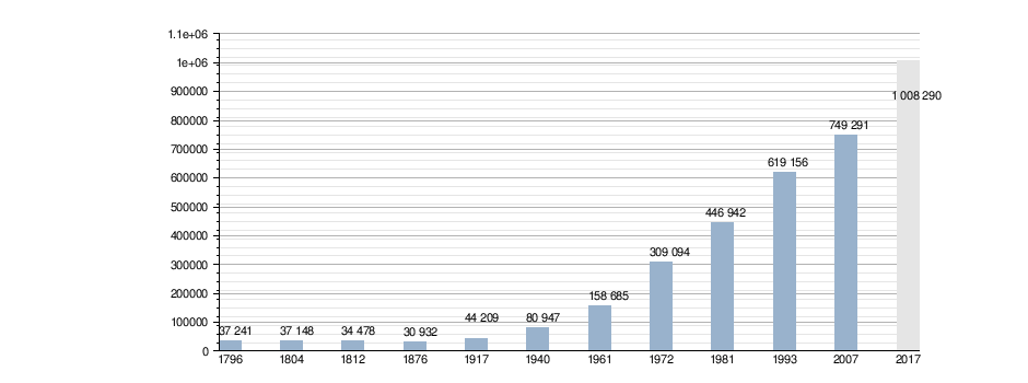
Sources: Population Census 1804 (Gil de Toboada) Viceroyalty of Peru in 1812, Census of inhabitants of Peru (1876), Census of the City of Arequipa in 1917 INEI, INEI 2012 population estimate
Regional Pride
Arequipa is known for its strong sense of regional pride. People from Arequipa are very proud of their city and its unique culture. This pride has often been linked to fighting against too much power being held in the capital, Lima. As one historian said, "Arequipa is a gun pointed at the heart of Lima," showing the friendly rivalry between the two cities.
Language and Dialect
Arequipa has its own special way of speaking Spanish. People often stretch out the last vowel of the final word in a sentence. Another unique feature is the use of "voseo," where vos is used instead of tú for "you." While this is mostly heard in rural areas of Peru, it's common in both city and country areas of Arequipa.
Famous Writers

Arequipa has a rich history of literature. Many writers from the city have become famous. In the 19th century, Mariano Melgar wrote patriotic poems and fables. In the 20th century, Mario Vargas Llosa became the most recognized Arequipan writer. He won the Nobel Prize in Literature in 2010.
Art and Photography
The Vargas Brothers Art Studio created some of the most detailed photos of Peru in the 19th and 20th centuries. Their studio was open from 1912 to 1958. They captured many different parts of Peruvian culture. Their photos, especially portraits of women, have been restored and shown around the world.
Museums to Explore
Arequipa's many museums showcase its rich history and art.
- The Museum of Contemporary Art has paintings and photos from the 1900s onwards. It features works by Peruvian artists.
- The Regional Museum of the Central Reserve Bank displays ancient Peruvian art and colonial coins.
- The Santa Maria University Museum of Archaeology and the Andean Sanctuaries Museum have important collections of ancient artifacts. The Andean Sanctuaries Museum is famous for housing Inca mummies.
-
The Universidad Nacional de San Agustín Museum, part of the National University of San Agustín.
-
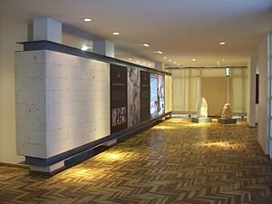
One of the halls of Arequipa's Museum of Contemporary Art
-
Entrance of the Museum of Andean Sanctuaries, famous for housing the girl sacrificed in the Ampato volcano, as well as various Incan artifacts.


Science and Culture

Arequipa has been home to important scientists. Pedro Paulet was a pioneer in rocket propulsion. Mariano Eduardo de Rivero y Ustariz was a famous geologist. Harvard University even operated an Astronomical Observatory in Arequipa from 1891 to 1927.
Cultural events are often organized by the city's universities and cultural centers. Many banks and private companies also support cultural projects.
Music Scene
Music is a big part of Arequipa's culture. In colonial times, composers like Mariano Melgar made Arequipa a known musical city. The Symphonic Orchestra of Arequipa, created in 1939, keeps classical and local music alive. Traditional music styles like vals criollo (Peruvian waltz) and yaravi are still popular.
Delicious Food

Arequipa's food is amazing, with about 194 typical dishes! It mixes European and Andean cooking styles. Many restaurants have a special main dish for each day of the week. For example, chaque on Mondays and chairo on Tuesdays.
Some popular local dishes include:
- Chupe de camarones (shrimp soup)
- Ocopa arequipeña (a creamy potato dish)
- Rocoto relleno (stuffed spicy peppers)
- Cuy chactado (fried guinea pig)
For desserts, try queso helado (ice cream made of milk, cinnamon, and coconut) or buñuelos. Two local drinks are chicha de guinapo (a dark corn drink) and anisado (anise liqueur).
Rocoto relleno is the most famous dish from Arequipa. It's like stuffed peppers, but it uses very spicy rocoto peppers. These peppers are grown in Peru and are much spicier than jalapeños. The Incas used to grow and prepare them.
Sports in Arequipa

Football (soccer) is the most popular sport in Arequipa. The biggest team is FBC Melgar, which plays in Peru's top league. They won national championships in 1981 and 2015. Arequipa has hosted major football events, including the 2004 Copa América.
The main stadiums in the city are:
- Virgen de Chapi Stadium (also known as Stadium of the UNSA)
- Mariano Melgar Stadium
- Los Palitos Stadium
- Umacollo Stadium
Virgen de Chapi Stadium is the second-largest stadium in Peru, holding over 60,000 people.
Places to See
The Historic Old Town
.jpg)
Arequipa's historic center covers 332 hectares (820 acres). It has 5,817 buildings, with 500 of them considered heritage sites. Many were rebuilt in the 19th century after an earthquake in 1868. The buildings are often made from ashlar, a white or pink volcanic stone. This stone is soft, light, and strong against earthquakes.
The architecture in Arequipa's historic center is unique. It's called the "Arequipeña School." It features detailed decorations, open spaces, and large entrances.
Major earthquakes have shaped Arequipa's architecture over time. There have been five main periods of building styles:
- Founding and early village (1540–1582)
- Baroque style (1582–1784)
- Rococo and Neoclassical styles (1784–1868)
- Modernizing and new ideas (1868–1960)
- Contemporary (today)
Religious Buildings
Arequipa's historic center has many beautiful religious buildings. There are 14 churches, four chapels, five convents, and three monasteries. Some important ones include:
- Basilica Cathedral of Arequipa: This is Peru's most important neoclassical building. It was rebuilt after 1844.
- Church of La Compañía (Church of the Jesuits): This church is a great example of the Arequipeña School style. It has very detailed Baroque decorations.
- Convent of Santa Catalina: A famous and beautiful monastery.

- Basilica and Convent of San Francisco, Arequipa

Public Buildings
There are 10 buildings that were originally used for public purposes. These include theaters, hospitals, bridges, and the railway station.
Homes and Mansions
The historic center has 246 houses that are considered monuments. These homes have thick walls, arches, and domes, similar to the churches. They were built from the 17th and 18th centuries and are very strong. Some famous ones are:
- Casa del Moral
- Goyeneche Palace
- Tristan del Pozo House
- Mint
Nearby Areas to Visit
- Yanahuara Villa Hermosa: About 2 kilometers (1.2 miles) from the city. It's known for its churches and alleys built in the Andalusian style.

- Cayma Villa: About 3 miles (4.8 kilometers) from the city center. It has a 17th-century church and a viewpoint with great views of Arequipa.
- Yura Thermal Baths: About 30 kilometers (18.6 miles) away. Its waters come from inside the Chachani volcano.
- Sabandía: A natural valley with very clear waters. Here you can find the Sabandía mill, which has been working since the 18th century.
- Sachaca Farm or the Founder's Mansion: About 12 kilometers (7.5 miles) from the city. This old residence belonged to important historical figures and is now open to the public.
Parks and Green Spaces
Arequipa has many parks and squares, covering 26 hectares (64 acres) in and around the historic center. Some popular ones are:
- Plaza de Armas (Main Square)
- Plaza San Francisco
- Parque Grau
- Parque Selva Alegre
There are also 22 hectares (54 acres) of countryside within the historic area. Other notable green spaces include:
- Parque Ecològico Alto Selva Alegre: Located in the eastern part of the city, covering 460 hectares (1,137 acres).
- Chilina Valley countryside: An area of 151 hectares (373 acres).
- Chilpinilla Metropolitan Park: 14 hectares (35 acres).
City Services
Healthcare

As a major city, Arequipa has many public and private healthcare centers, totaling 680 establishments. These include hospitals like Carlos Seguin National Hospital and Honorio Delgado Regional Hospital.
Water Supply
The water supply in Arequipa can vary by neighborhood. Sometimes, water interruptions happen because the underground pipes are old and need repairs. These interruptions can be longer in the outer parts of the city.
Getting Around
Roads and Traffic

Arequipa's roads spread out from the center. Four main avenues help people move between the city center and outer areas. These main avenues are connected by others, forming a ring around downtown. Interchanges help ease traffic. One road connects Arequipa to the Pan-American Highway and coastal cities. Another road connects it to cities in the southern highlands like Puno and Cuzco.
Public transport is run by private companies. There have been proposals for a metro system to improve travel.
Air Travel

Arequipa's only airport is Rodríguez Ballón International Airport. It is located about 12 miles (19 kilometers) northwest of downtown. It is considered one of the best airports in Peru. You can fly to Peruvian cities like Lima and Cuzco, and to international places like Santiago de Chile.
Train Travel
Arequipa has had a railway system since 1871. It connects the coast to the mountains and helps transport heavy goods over long distances. The main lines are Cusco-Puno-Arequipa and Arequipa-Mollendo.
Bus Travel
The Terrapuerto Internacional Arequipa is a large bus terminal. Many bus companies offer trips to other cities in Peru and to international destinations like La Paz and Buenos Aires.
Famous People from Arequipa
- Max González Olaechea (1867–1946), a doctor and university professor.
- Bruno Montenegro (born 1991), a trans rights activist and film director.
- Augusto Pérez Araníbar (1858–1948), a doctor and helper of others.
- Patricia Salas O'Brien (born 1958), a sociologist and former Minister of Education.
- Mario Vargas Llosa (1936–2025), a famous novelist and journalist who won the Nobel Prize in Literature.
Sister Cities
Arequipa has "sister city" relationships with many cities around the world. This means they share cultural and economic ties.
 Charlotte, United States (1962)
- Maui County, United States (1994)
 Corrientes, Argentina (1973)
 Arica, Chile (1991)
- Iquique, Chile (2005)
 Guangzhou, China (2004)
 Ponta Grossa, Brazil (2005)
- Lins, Brazil (2007)
 El Tocuyo, Venezuela (2007)
 Biella, Italy (1985)
 Cochabamba, Bolivia (1990)
 Puebla, Mexico (2006)
- Morelia, Mexico (1991)
- Guanajuato, Mexico (2004)
See also
 In Spanish: Arequipa para niños
- List of colonial buildings in Arequipa
- Arequipa Region
- Metropolitan areas of Peru
- Goyeneche Palace
- Tourism in Peru
