
Chachani facts for kids
Quick facts for kids Chachani |
|
|---|---|

Chachani viewed from the south
|
|
| Highest point | |
| Elevation | 6,057 m (19,872 ft) |
| Prominence | 1,976 m (6,483 ft) |
| Parent peak | Huascaran |
| Geography | |

Chachani
Location in Peru
|
|
| Geology | |
| Mountain type | Volcanic complex |
| Last eruption | Unknown |
Chachani is a large volcanic group in southern Peru. It is about 22 kilometers (14 miles) northwest of the city of Arequipa. This volcano is part of the Central Volcanic Zone of the Andes mountains. It stands very tall, at 6,057 meters (19,872 feet) above sea level.
Chachani is made up of several parts. These include lava domes and individual volcanoes like Nocarane. There are also wide, flat areas of lava called lava shields, such as the Airport Domes. A large, bowl-shaped hollow called a caldera lies underneath Chachani.
Millions of years ago, during the Pliocene and early Pleistocene periods, Chachani produced huge amounts of ash and rock. These formed thick layers called ignimbrites. After this, the main volcano grew inside the caldera. Chachani has not erupted in modern history. However, it is considered a "dormant" (sleeping) volcano. Because it is so close to Arequipa, it is seen as a high-risk volcano.
Contents
What's in a Name?
The name "Chachani" has special meanings. In the Aymara language, it means "brave." It can also mean "mountain of man" or "mountain of male." You might sometimes see it spelled as "Cacheni" or "Charchani."
Where is Chachani and What Does it Look Like?
Chachani is located in the Andes mountains of southern Peru. It is about 22 kilometers (14 miles) northwest of Arequipa. The city of Arequipa sits at the base of Chachani and another volcano called El Misti. A road from Arequipa to Chivay runs along Chachani's southeastern side. A dirt road even goes up to 5,000 meters (16,400 feet) high.
Chachani is known as one of the easiest mountains between 6,000 and 7,000 meters (19,685 and 22,966 feet) to climb. But you still need to get used to the high altitude. You also need to be in good physical shape to climb it safely.
Peru has many volcanoes in its southern region. Some of these include Coropuna, Sabancaya, Ampato, and Ubinas. Ubinas has erupted many times since 1954. Huaynaputina had a very large eruption in the year 1600. Peruvian volcanoes are part of the Central Volcanic Zone of the Andes. This zone has 44 named stratovolcanoes.
Chachani is a large group of volcanoes. It is about 2 kilometers (1.2 miles) high and 17 kilometers (10.5 miles) wide. It includes lava domes, stratovolcanoes, and volcanic cones. The highest point is 6,057 meters (19,872 feet) high. This makes Chachani the 84th tallest peak in the Andes. The Chachani area includes the main Chachani volcano and Nocarane to the north. Other peaks are La Horqueta, El Rodado, los Ángeles, and Trigo. In total, Chachani is made of more than 12 different volcanic parts.

To the south of Chachani are the Airport Domes. This is an 8-kilometer (5-mile) wide lava shield. It looks very new and fresh. It is made of many layers of lava flows. A large volcanic caldera might be hidden under Chachani. This caldera is linked to the widespread ignimbrites found in the Arequipa area. The El Misti volcano later grew on the edge of this Chachani caldera.
The Chachani volcano is mostly made of rough, blocky lava flows. These lava flows usually travel about 10 kilometers (6 miles). It also has pyroclastic flows (fast-moving hot gas and rock) and tephra (volcanic ash and rock fragments). The whole volcanic area covers about 600 square kilometers (230 square miles). It is one of the largest volcanoes in the Andes. Over time, glaciers and landslides have changed the shape of the volcano. They have created bowl-shaped hollows and U-shaped valleys.
Chachani's water drains into the Rio Chili. Several streams flow from Chachani into this river. The Rio Chili flows around the southeastern side of Chachani. It has carved a deep canyon between Chachani and El Misti. Other rivers like the Rio Sumbay and Rio Yura also flow near Chachani. Eventually, all this water flows into the Pacific Ocean.
Past Glaciers on Chachani
In the past, Chachani had five periods of glaciation (covered by glaciers). During the last major ice age, large glaciers formed. They left behind piles of rock and dirt called moraines. These moraines can be found at elevations of 3,150 to 3,600 meters (10,330 to 11,800 feet). Smaller glaciers might have also formed during the Little Ice Age. Today, however, Chachani does not have any glaciers. It only has a small snowfield at its top. Glaciers in the Andes have been shrinking, especially since the 1970s.
Even without glaciers, Chachani still has permafrost (ground that stays frozen) and rock glaciers. These are found near Nocarane and can be up to 1.8 kilometers (1.1 miles) long. Some of these rock glaciers are still moving slowly. They are located above 4,810 meters (15,780 feet) elevation. Other frozen ground features, like needle ice, can also be found on the volcano.
-
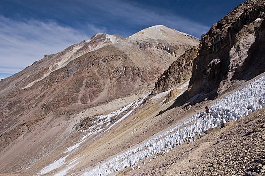
Chachani, looking eastward
-
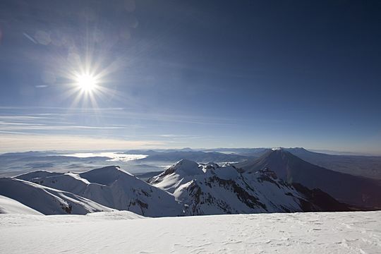
Summit area
-
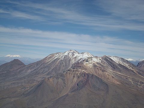
Chachani viewed from El Misti
_(5619838885).jpg)

.jpg)
How Chachani Formed
The Earth's plates are always moving. The Nazca Plate is sliding under the South America Plate. This process is called subduction. It causes volcanoes and earthquakes in the region. In the Andes, there are three main volcanic belts. Chachani is in the Central Volcanic Zone.
Volcanic activity in the Chachani area began a very long time ago. The oldest volcanic rocks are from the Cretaceous and Paleocene periods. Chachani itself is made of volcanic rocks that are millions of years old. These rocks sit on top of even older rocks.
The younger El Misti volcano is southeast of Chachani. Other volcanoes in the region include Ampato and Pichu Pichu. Chachani, Misti, and Pichu Pichu are lined up along cracks in the Earth's crust. They have been active in recent geological times.
Chachani has erupted different types of lava. These include andesite and dacite. These lavas are rich in potassium. The rocks also contain various minerals like augite, biotite, and hornblende. The type of lava erupted by Chachani has changed over its long history.
Climate and Plants
The region around Chachani has a very dry climate. This is because of the cold Humboldt Current in the Pacific Ocean. Arequipa gets less than 100 millimeters (4 inches) of rain each year. The temperature at Chachani can change a lot between day and night. It can vary by 20 degrees Celsius (36 degrees Fahrenheit).
Between 3,500 and 3,900 meters (11,500 and 12,800 feet) elevation, you can find some plants. These include cacti, herbs, Peruvian feather grass, and yareta. You can also see lichens and mosses. Above 4,500 meters (14,760 feet), there is very little to no plant life. The dry soil is not good for farming. Part of the volcano is in the Salinas y Aguada Blanca National Reserve.
Chachani's Eruption History
The oldest volcanic rocks from Chachani are called "sillars." These are light-colored ash and rock flows. They include the La Joya Ignimbrite, which is 4.8 million years old. The Arequipa Airport Ignimbrite is 1.65 million years old. These were likely the biggest eruptions from Chachani. These fast-moving, hot streams of rock covered a wide area around Arequipa.
Later, during the Quaternary period, the main Chachani volcano grew. Older parts of the volcano formed first, like Chingana, Estribo, and Nocarane. These are between 1 million and 500,000 years old. Later, other parts like El Rodado, La Horqueta, and the main Chachani formed. This happened around 130,000 to 131,000 years ago. The Airport Domes to the south formed between 290,000 and 400,000 years ago.
The youngest known lava flows are about 56,500 years old. There are no records of Chachani erupting in human history. The exact date of its last activity is not clear.
However, there are signs that Chachani is still active. There are solfataras (vents releasing volcanic gases) near the summit. There are also hot springs at Socosani and Yura. The volcano also has frequent small earthquakes on its southwestern side. These might be linked to heat from underground or shifting rocks. Chachani is currently considered a dormant volcano. Sometimes, mudflows can come down its slopes, causing damage in lower areas.
Volcano Hazards
.jpg)
The city of Arequipa has about one million people. Important buildings and services like the airport, hydropower plants, and water reservoirs are close to Chachani. People have built homes all around its base. The western parts of Arequipa are less than 25 kilometers (15.5 miles) from the volcano. If Chachani were to erupt again, these areas could be in danger from pyroclastic flows.
Melting ice and snow on the summit could also create dangerous mudflows. Lava flows and falling tephra (ash and rock) are other dangers. Because of these risks, Chachani is considered a high-risk volcano. In 2018, the Geophysical Institute of Peru set up a monitoring station on Chachani. As of 2021, scientists are preparing maps to show the danger zones. They are watching Chachani with special tools like seismometers (to detect earthquakes) and tiltmeters (to measure ground movement). Besides eruptions, there is also concern about the volcano possibly polluting nearby water sources.
Chachani's Cultural Importance
Chachani is seen as a protector mountain spirit for the people of Cayma. People in Arequipa sometimes call Chachani the "father" of El Misti volcano. They believed it could influence whether newborn babies would be daughters.
The Inca people worshipped Chachani and the mountains around it. They built a special mountain sanctuary on its summit. Sadly, this site was later destroyed by sulfur mining and people looking for treasures. Because of this, no traces of the original archeological sites, like walls, can be found today. However, evidence of Inca human sacrifice ceremonies, known as capacocha, was found during expeditions. The first known finding of such a sacrifice was on Chachani in 1896.
Mining on Chachani
During the time of Spanish rule, Chachani was mined for sulfur. It was also a source of the white "sillar" rocks. These rocks were used to build the famous buildings in colonial Arequipa. This is why Arequipa is also known as the "white city."
See also
 In Spanish: Chachani para niños
