Sabancaya facts for kids
Quick facts for kids Sabancaya |
|
|---|---|
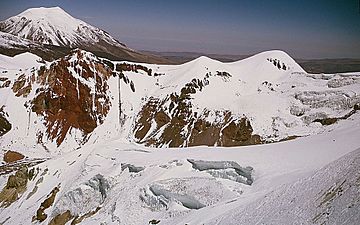
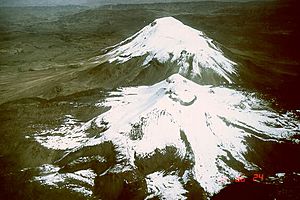
Aerial view of Sabancaya, the summit in the left background is Ampato
|
|
| Highest point | |
| Prominence | ~500 m (1,640 ft) |
| Geography | |
| Location | Southern Peru |
| Parent range | Andes |
| Geology | |
| Mountain type | Stratovolcano |
| Volcanic arc/belt | Central Volcanic Zone |
| Last eruption | September 2022 (ongoing) |
Sabancaya is an active volcano in the southern Andes mountains of Peru. It stands about 5,976-metre-high (19,606 ft) and is located roughly 70 kilometres (43 mi) northwest of the city of Arequipa. Sabancaya is a type of volcano called a stratovolcano, which means it's cone-shaped and built up by many layers of hardened lava, ash, and rocks.
It is part of the Central Volcanic Zone of the Andes, one of the main areas where volcanoes are found in these mountains. Many volcanoes in this zone, like Sabancaya and Ubinas, have been active in recent times. Sabancaya is connected to two other volcanoes, Hualca Hualca to the north and Ampato to the south. It has erupted a type of lava called andesite and dacite. The volcano also has a small ice cap on top, which means there's a risk of dangerous mudslides called lahars during eruptions.
Long ago, Sabancaya produced many long lava flows. More recently, its eruptions have been more explosive. People have reported eruptions since the 1700s. The volcano became active again in 1986, with a big eruption in 1990. Since then, it has been continuously active, releasing ash and gas.
Contents
What Does the Name Sabancaya Mean?
The name "Sabancaya" comes from the Quechua language. It means tongue of fire or spitting volcano. This name likely refers to how active the volcano has been. Records show the name has been used since 1595, suggesting that people have seen the volcano erupting for a very long time.
Where is Sabancaya Located?
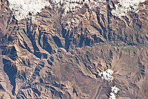
Sabancaya is about 70 km (43 mi) northwest of Arequipa, a major city in Peru. The Rio Colca valley is just north of the Sabancaya-Hualca Hualca-Ampato volcano group. The main ways people make a living in this area are farming, raising animals, mining, and tourism.
How Volcanoes Form in the Andes
The Andes mountains have many volcanoes because of how the Earth's plates move. The Nazca Plate is slowly sliding underneath the South American Plate in a deep ocean trench called the Peru-Chile Trench. This process, called subduction, causes rocks to melt deep underground, forming magma. This magma then rises to the surface, creating volcanoes.
This volcanic activity happens in different sections along the Andes. Sabancaya is in the Central Volcanic Zone, which stretches through southern Peru. Many volcanoes in this zone are not well-known because they are in remote, high-altitude areas.
Sabancaya is one of several volcanoes along the southwestern coast of Peru, about 100 kilometres (62 mi) from the ocean. Other volcanoes in this area that have been active recently include El Misti, Ubinas, and Huaynaputina. Some of these volcanoes, like Ampato and Coropuna, are very tall, over 6,000 metres (20,000 ft).
These volcanoes often form where cracks in the Earth's crust, called faults, cross each other. These faults can help magma rise to the surface. The ground around Sabancaya still moves, causing small earthquakes. This movement can be linked to magma moving underground.
Sabancaya's Shape and Neighbors
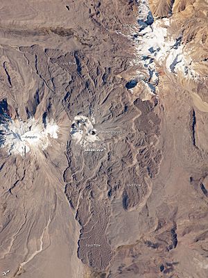
Sabancaya is 5,960 metres (19,554 ft) tall and rises 1,500 metres (4,920 ft) above the land around it. It is part of a group of volcanoes with Hualca Hualca to the north and Ampato to the south. These volcanoes stand tall above the Colca Canyon in the north. Ampato and Hualca Hualca are older and more worn down than Sabancaya. Sabancaya is the youngest volcano in this group.
Sabancaya actually has two main parts, called Sabancaya I North and Sabancaya II South. The main summit crater is between these two parts. Even with an ice cap, you can see old lava flows near the top. These lava flows cover a large area, about 68 square kilometres (26 sq mi), and some stretch up to 8 km (5.0 mi) away from the volcano. The older lava flows are farther away from the center. These flows are thick, sometimes 60–170 metres (200–560 ft) deep.
Like its neighbors, Sabancaya has an ice cap. In 1988, this ice cap covered an area of 3.4 square kilometres (1.3 sq mi). However, between 1986 and 2016, the volcano lost more than three-quarters of its ice. The remaining ice has broken into smaller pieces. Evidence from past ice ages shows that much larger glaciers once covered the area.
Scientists have found a possible underground magma chamber about 10 kilometres (6.2 mi) northeast of Sabancaya. This area has shown signs of ground swelling, which means magma might be moving there. Sometimes, the magma chamber for Sabancaya might even be under the neighboring Hualca Hualca volcano.
What is Sabancaya Made Of?
The rocks that make up Sabancaya are mostly andesite and dacite. These are types of volcanic rocks that are rich in potassium. They are similar to rocks found in other volcanoes in southern Peru. The rocks are not very bubbly and contain small crystals of minerals like amphibole, biotite, hornblende, plagioclase, and pyroxene.
The magma that forms these rocks is very hot, between 920–990 °C (1,688–1,814 °F). Scientists believe that the magma interacts with the Earth's crust deep underground before rising. In shallower magma chambers, the magma mixes and changes, forming the different types of rocks seen at Sabancaya.
Sabancaya also releases a lot of volcanic gases, like sulfur dioxide (SO2) and water (H2O). The amount of water released is very large for a volcano. Sabancaya and Ubinas are among the biggest emitters of CO2 and H2O in the Central Volcanic Zone.
Sabancaya's Eruption History
Initially, the Ampato volcano was the most active in the area. Then, activity shifted to Sabancaya, though both volcanoes erupted for a time. Today, most of Sabancaya's activity involves lava domes and lava flows. Some of these lava flows are thousands of years old. Explosive eruptions are less common.
There is evidence that the Inca people may have performed human sacrifices in response to Sabancaya's eruptions. They might have done this to try and calm the mountain spirits.
Records from Spanish explorers mention possible eruptions in 1752 and 1784. After the 1700s, the volcano was quiet for about 200 years, with only steam coming out. In late 1986, more steam and gas started to appear, signaling a new active period. Satellite images even showed black spots where the ice had melted. Animals in the area were also affected.
This period of activity reached its peak in May 1990 with a large eruption. This eruption sent ash up to 12 kilometres (7.5 mi) away from the top of the volcano. It also caused strong earthquakes and created eruption columns that reached heights of 7 km (4.3 mi). The eruption made the summit crater bigger and created new steam vents. This eruption caused between 4,000 and 1,500 people to move away from the region.
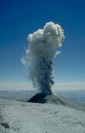
After the big 1990 eruption, Sabancaya's activity changed. It started having frequent, small explosive eruptions. These eruptions threw rocks up to 1 kilometre (0.62 mi) from the crater. Ash from these eruptions caused glaciers on Ampato to melt in 1995, which famously uncovered the Mummy Juanita. Over time, these explosive eruptions became less frequent.
In 2013 and 2014, the volcano showed more signs of activity, with increased steam and gas. An eruption happened in August 2014. The volcano also released more sulfur dioxide. Ash was released many times in 2014 and 2015.
Activity increased again in 2016, with new steam vents and more sulfur dioxide. Ash eruptions began on November 6, 2016, with an eruption column 3 km (1.9 mi) high a few days later. This new activity was also linked to ground swelling at Hualca Hualca, showing that the two volcanoes might share an underground magma system. Since then, Sabancaya has been continuously active with many daily explosions. These explosions create volcanic ash clouds that can rise up to 3.5 km (2.2 mi). A constant gas plume hangs over the volcano, and ash emissions have led to alerts for local people. Mudflows (lahars) have also occurred sometimes, but without causing damage. A new lava dome started growing inside the crater in 2017. In 2020, a second lava dome formed but was later destroyed. Ash and seismic activity continued through 2021 and 2022.
What are the Dangers from Sabancaya?
Sabancaya rises above the valleys of the Colca River and Siguas River, where about 35,000 people live. The volcano is especially dangerous for the Colca River valley, which is 18 kilometres (11 mi) north of the volcano. This valley is a big tourism spot in Peru, with about 190,000 visitors each year. Many towns, like Chivay and Maca, are in this valley. About 30,000 people live within 30 kilometres (19 mi) of the volcano.
Roads and a major power line that brings electricity to southern Peru are on the sides of Sabancaya. These could be damaged in an eruption. If a very large eruption happened, at least 60,000 to 70,000 people could be in danger. Rocks falling and hot, fast-moving flows of gas and ash (called pyroclastic flows) would affect areas close to the volcano.
The volcano's ice cap is another danger. If it melts during an eruption, it could create dangerous mudflows called lahars. These mudflows could threaten the Majes River and Sihuasi River areas, where there is a big farming project. Other dangers from eruptions include tephra (ash and rock fragments) falling, which can affect people's health. Lava flows are usually slow and not a big threat to people.
Scientists in Peru started watching volcanoes after the 1986 eruption. The Southern Volcano Observatory was created to monitor Sabancaya. The monitoring system around the volcano was improved after its 2013 eruption. The Peruvian Volcanological Observatory uses special tools like seismometers (to detect earthquakes) and surveillance cameras to watch Sabancaya. They also use satellite data and collect ash. They have created a map showing the hazard areas.
Besides direct eruption dangers, Sabancaya also adds sulfur dioxide to the air in the Colca valley. This can harm plants and cause breathing problems for animals and people. Ash clouds from Sabancaya often make air travel difficult in the region. Sabancaya is one of the volcanoes that most often causes warnings for air traffic due to volcanic ash.
See also
 In Spanish: Sabancaya para niños
- List of volcanoes in Peru
- Lake Mucurca
 | William Lucy |
 | Charles Hayes |
 | Cleveland Robinson |


