
Lima facts for kids
Quick facts for kids
Lima
Ciudad de Los Reyes
|
|||||||||||||||||||
|---|---|---|---|---|---|---|---|---|---|---|---|---|---|---|---|---|---|---|---|
|
San Isidro skyline
Archbishop's Palace and Metropolitan Cathedral
Fountain of Plaza Mayor
Park of the Reserve
San Francisco el Grande Basilica
Miraflores skyline
|
|||||||||||||||||||
|
|||||||||||||||||||
| Nickname(s):
Ciudad de los Reyes (City of the Kings)
La Tres Veces Coronada Villa (The Three Times Crowned Ville) La Perla del Pacífico (The Pearl of the Pacific) |
|||||||||||||||||||
| Motto(s): | |||||||||||||||||||

Lima
Location in Peru
|
|||||||||||||||||||
| Country | |||||||||||||||||||
| Province | Lima | ||||||||||||||||||
| Established | 18 January 1535 | ||||||||||||||||||
| Founded by | Francisco Pizarro | ||||||||||||||||||
| Area | |||||||||||||||||||
| • City | 2,672.3 km2 (1,031.8 sq mi) | ||||||||||||||||||
| • Urban | 800 km2 (300 sq mi) | ||||||||||||||||||
| • Metro | 2,819.3 km2 (1,088.5 sq mi) | ||||||||||||||||||
| Elevation | 0–1,550 m (0–5,090 ft) | ||||||||||||||||||
| Population
(2023)
|
|||||||||||||||||||
| • Rank | 2nd in South America 1st in Peru |
||||||||||||||||||
| • Urban | 9,751,717 | ||||||||||||||||||
| • Urban density | 12,200/km2 (31,600/sq mi) | ||||||||||||||||||
| • Metro | 11,283,787 | ||||||||||||||||||
| • Metro density | 4,002.3/km2 (10,366/sq mi) | ||||||||||||||||||
| Demonyms | Limeño/a | ||||||||||||||||||
| GDP (PPP, constant 2015 values) | |||||||||||||||||||
| • Year | 2023 | ||||||||||||||||||
| • Total | $210.4 billion | ||||||||||||||||||
| Time zone | UTC−05:00 (Peru Time) | ||||||||||||||||||
| • Summer (DST) | (Not Observed) | ||||||||||||||||||
| UBIGEO |
15000
|
||||||||||||||||||
| Area code | 1 | ||||||||||||||||||
|
|||||||||||||||||||

.jpg)
.jpg)
.jpg)

.jpg)


Lima is the capital and largest city of Peru. It was founded in 1535 by Francisco Pizarro and was originally called the Ciudad de los Reyes (City of Kings). Lima is located in the valleys of the Chillón, Rímac, and Lurín rivers, right on the coast of Peru, overlooking the Pacific Ocean.
This city is very important for Peru. It is the country's main center for politics, culture, money, and business. Lima is also a "beta" tier city, which means it's a globally important city. The city is mostly in the Lima Province. A smaller part is in the Constitutional Province of Callao, where you'll find the main seaport and the Jorge Chávez Airport.
In 2023, Lima had about 10 million people, making it the most populated city in Peru. It's also the second most populated city in the Americas, after São Paulo. When you include the nearby city of Callao, the Lima Metropolitan Area has over 11 million people. This makes it one of the thirty largest urban areas in the world.
Lima was chosen to host the 2019 Pan American Games, which was the biggest sports event Peru had ever hosted. The city has also hosted important international meetings and events.
Contents
What's in a Name?
The area where Lima is now was once called Itchyma by its first people. Before the Incas arrived, there was a famous oracle in the Rímac Valley. Visitors knew this oracle as Limaq, which means "talker" or "speaker" in the local Quechua language. Even after the Spanish destroyed the oracle and built a church, the name Limaq stuck.
Modern experts believe that "Lima" comes from the Spanish way of saying Limaq. The city was officially founded in 1535 as the "City of Kings" (Ciudad de los Reyes). This name was chosen because the city's founding was decided on January 6, which is the Christian holiday of Epiphany. However, people quickly started calling it "Lima" instead.
The river that flows through Lima is called the Rímac. Some people think this name means "Talking River" in Inca language. But the original people of the valley were not Incas. The name "Rímac" came later, when people tried to make it sound more like the Inca language spoken in Cuzco.
City Symbols
The Flag of Lima
The Flag of Lima is also known as the "Banner of the City of the Kings of Peru." It's a gold-colored silk flag with the city's coat of arms embroidered in the center.
The Coat of Arms

The coat of arms of Lima was given to the city by the Spanish Crown on December 7, 1537. It has a blue background with three gold crowns arranged in a triangle. Above them is a gold star that touches all three crowns. Around the edge, there are gold letters that say: Hoc signum vere regum est, which means "This is the true sign of the kings."
Outside the shield, you can see the letters "I" and "K." These stand for Queen Joanna and her son Charles V, who granted the coat of arms. A star is placed above these letters, and two crowned eagles hold the shield.
The Anthem of Lima
Lima has its own anthem! It was first played on January 18, 2008. The lyrics were written by Luis Enrique Tord, the music by Euding Maeshiro, and Ricardo Núñez arranged it.
Lima's Story
Ancient Times

Even before the Spanish arrived in 1535, the Lima area was home to ancient cultures. These groups lived in the valleys of the Rímac, Chillón, and Lurín rivers. The Maranga and Ichma cultures were very important here. They built special places like the sanctuaries of Lati (now Puruchuco) and Pachacámac. Pachacámac was a major pilgrimage site for many centuries, even during Inca times.
Later, the Wari Empire took over these lands. During this time, the ceremonial center of Cajamarquilla was built. After the Wari Empire declined, local cultures like the Chancay became strong again. In the 15th century, the area became part of the Inca Empire. Today, you can still find many ancient structures called huacas throughout Lima.
Some of the most famous huacas are Huallamarca, Pucllana, and Mateo Salado. These ancient sites are surrounded by modern buildings in busy parts of Lima, but they are still well-preserved. During Inca times, the Lima valley was very populated and organized into a province called Pachacamac. Historians believe that around 150,000 people lived here during the Inca period.
The local lord of the Lima valley, near the Rímac river, was named Taulichusco. Some important buildings in Lima today stand on the sites of ancient structures. For example, the Government Palace is where Taulichusco's palace once stood. The Cathedral of Lima is on the site of an old temple called Puma Inti.
Spanish Foundation
In 1532, the Spanish, led by Francisco Pizarro, captured the Inca ruler Atahualpa. After some battles, the Spanish conquered the Inca Empire. Pizarro decided to create a new capital city in the Rímac river valley. He thought this spot was perfect because it was close to a good port but far enough inland to be safe from pirate attacks. The land was also fertile, and the climate was pleasant.
So, on January 18, 1535, Lima was founded. It was named "City of the Kings" in honor of the Epiphany holiday. Pizarro himself helped design the city, including the main square (Plaza Mayor) and important buildings like the Viceroyalty Palace (now the Government Palace) and the Cathedral.
In August 1536, the city was attacked by Inca general Quizu Yupanqui. But the Spanish and their local allies managed to defend Lima. The help from the Huaylas army, led by Contarhuancho, was especially important.
Over the next few years, Lima became very important. It was named the capital of the Viceroyalty of Peru in 1543. This meant it was the center of Spanish rule in a large part of South America. The city quickly formed a strong connection with the nearby port of Callao.
Colonial Times


For about a hundred years, Lima grew wealthy as a major trading hub. It connected the viceroyalty with the Americas, Europe, and Asia. However, the city faced challenges. Strong earthquakes in 1586 and 1687 destroyed much of it. This led to a lot of rebuilding. New structures like aqueducts, bridges, and retaining walls were built to protect against floods. The cathedral was completed, and many hospitals, convents, and monasteries were constructed.
Another danger was pirates and corsairs in the Pacific Ocean. To protect the city, the Walls of Lima were built between 1684 and 1687.
The 1687 earthquake also marked a change for Lima. Trade slowed down because other cities like Buenos Aires started to compete. In the 18th century, new ideas about public health and city planning influenced Lima's development. Buildings like the Acho Bullring and the General Cemetery were constructed. The cemetery ended the practice of burying the dead in churches, which was seen as unhealthy.
-
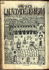
"The City of the Kings of Lima, royal high court, principal city of the kingdom of the Indies, residence of the viceroy[...]", painting of 1615 by the Inca painter Guamán Poma. Royal Library, Denmark.
-
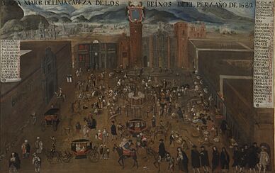
The unfinished cathedral of Lima in the Plaza Mayor, painting of 1680. Museo de América (Madrid).
-
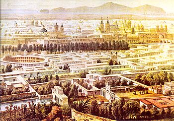
Lima as seem from the Rímac District, painting of 1850 by Batta Molinelli
-
Colonial Calle de los Judíos (Jewish quarter) (Lima) in 1866 by Manuel A. Fuentes and Firmin Didot, Brothers, Sons & Co. University of Chicago Library.
-
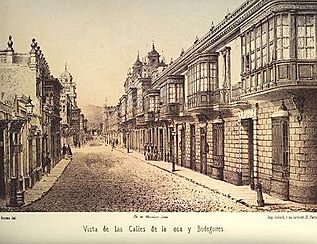
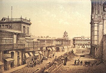
Colonial Calles de la Oca and de Bodegones (Lima) in 1866 by Manuel A. Fuentes and Firmin Didot, Brothers, Sons & Co. University of Chicago Library.
-
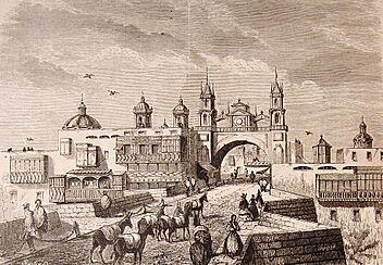
Puente de Piedra Bridge, the former Arco del Puente Gate and the Walls of Lima in 1878 by El Viajero Ilustrado. Old Fund of the University of Seville.


.jpg)

_1866.jpg)
_1866.jpg)
.jpg)
Independence and Republic

In 1820, General José de San Martín and his army arrived near Lima. The Spanish viceroy left the city in July 1821. The city council then invited San Martín to enter, and he declared Peru's independence. Lima became the capital of the new Republic of Peru. The war continued for two more years, and Lima suffered a lot during this time.
After the war, Lima's growth was slow due to economic problems. But in the 1850s, things changed. Money from guano (bird droppings used as fertilizer) exports helped the city expand quickly. New public buildings were constructed, and transportation improved. A railway line to Callao was finished in 1850, and an iron bridge over the Rímac River opened in 1870. In 1872, the old colonial city walls were taken down to allow for more urban growth.
During the War of the Pacific (1879–1883), the Chilean army occupied Lima. The city's museums and libraries were looted.
20th Century Growth

In the early 1900s, Lima began building new avenues to help the city grow. Major construction projects started in the 1930s, including the remodeling of the Government Palace. This building boom continued into the 1950s, with many new ministries, hospitals, and the National Stadium being built.
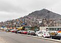
Around this time, many people from other parts of Peru moved to Lima. This caused the city's population to grow very fast and led to new communities being built. Areas like Lince, La Victoria, Breña, and Pueblo Libre became populated. In 1973, the community of Villa El Salvador was created, which is now a large district.
By 1980, Lima's population reached 4.8 million. New communities, often called pueblos jóvenes, spread out from the city center.
Lima's Location and Climate
Geography of Lima


Lima is built on mostly flat land in the Peruvian coastal desert. It sits in the valleys of the Chillón, Rímac, and Lurín rivers. The city gently slopes from the Pacific Ocean shores up to mountain slopes that can be as high as 1,550 meters (5,090 feet) above sea level. There are also some isolated hills within the city, like El Agustino and San Cristobal.
The Lima metropolitan area covers about 2,672 square kilometers (1,032 sq mi). The city itself takes up about 826 square kilometers (319 sq mi). The urban area stretches about 60 kilometers (37 mi) from north to south and 30 kilometers (19 mi) from west to east. The city center is about 15 kilometers (9 mi) inland, by the Rímac River. This river is very important because it provides drinking water and powers hydroelectric dams for the city.
Lima is known as the world's third-largest desert city, after Karachi, Pakistan, and Cairo, Egypt.
Lima's Climate

Lima has a mild climate, even though it's in a desert and near the tropics. The Pacific Ocean's cool waters keep temperatures from getting too hot or too cold. Temperatures rarely drop below 12°C (54°F) or rise above 30°C (86°F).
There are two main seasons:
- Summer (December to April): Sunny, hot, and humid. Daily temperatures are usually between 18°C (64°F) and 30°C (86°F). Sometimes there's morning fog or high clouds in the afternoon. Summer sunsets are very colorful, often called "sky of witches" by locals.
- Winter (June to October): The weather is very different. Skies are often gray, it's breezy, and humidity is high. Temperatures are cooler, usually between 14°C (57°F) and 19°C (66°F). Light drizzle, called garúa, often happens in the mornings from June to September.
Lima has very high humidity, especially in the mornings. This causes a lot of fog in early summer and a thick layer of low clouds during winter. Lima gets very little sunshine each year, which is unusual for its location. People often go to Andean valleys above 500 meters (1,640 feet) in winter to find sunshine.
Even with high humidity, it rarely rains much in Lima. This is because of the cool ocean waters and the cold Humboldt Current. The lack of heavy rain affects the city's water supply, which comes from wells and rivers from the Andes mountains.
The climate can change a lot during El Niño events. The ocean water gets much warmer, and air temperatures rise too.
| Climate data for Lima (Jorge Chávez International Airport) 1961–1990, extremes 1960–present | |||||||||||||
|---|---|---|---|---|---|---|---|---|---|---|---|---|---|
| Month | Jan | Feb | Mar | Apr | May | Jun | Jul | Aug | Sep | Oct | Nov | Dec | Year |
| Record high °C (°F) | 32.7 (90.9) |
32.5 (90.5) |
33.4 (92.1) |
31.6 (88.9) |
30.3 (86.5) |
30.0 (86.0) |
28.3 (82.9) |
29.0 (84.2) |
28.0 (82.4) |
29.6 (85.3) |
29.0 (84.2) |
30.4 (86.7) |
33.4 (92.1) |
| Mean daily maximum °C (°F) | 26.1 (79.0) |
26.8 (80.2) |
26.3 (79.3) |
24.5 (76.1) |
22.0 (71.6) |
20.1 (68.2) |
19.1 (66.4) |
18.8 (65.8) |
19.1 (66.4) |
20.3 (68.5) |
22.1 (71.8) |
24.4 (75.9) |
22.5 (72.5) |
| Daily mean °C (°F) | 22.1 (71.8) |
22.7 (72.9) |
22.2 (72.0) |
20.6 (69.1) |
18.8 (65.8) |
17.5 (63.5) |
16.7 (62.1) |
16.2 (61.2) |
16.4 (61.5) |
17.3 (63.1) |
18.7 (65.7) |
20.7 (69.3) |
19.2 (66.6) |
| Mean daily minimum °C (°F) | 19.4 (66.9) |
19.8 (67.6) |
19.5 (67.1) |
17.9 (64.2) |
16.4 (61.5) |
15.6 (60.1) |
15.2 (59.4) |
14.9 (58.8) |
14.9 (58.8) |
15.5 (59.9) |
16.6 (61.9) |
18.2 (64.8) |
17.2 (63.0) |
| Record low °C (°F) | 12.0 (53.6) |
15.0 (59.0) |
11.0 (51.8) |
10.0 (50.0) |
8.0 (46.4) |
10.0 (50.0) |
8.9 (48.0) |
10.0 (50.0) |
12.5 (54.5) |
11.0 (51.8) |
11.1 (52.0) |
13.9 (57.0) |
8.0 (46.4) |
| Average precipitation mm (inches) | 0.8 (0.03) |
0.4 (0.02) |
0.4 (0.02) |
0.1 (0.00) |
0.3 (0.01) |
0.7 (0.03) |
1.0 (0.04) |
1.5 (0.06) |
0.7 (0.03) |
0.2 (0.01) |
0.1 (0.00) |
0.2 (0.01) |
6.4 (0.25) |
| Average precipitation days (≥ 0.1 mm) | 0.7 | 0.7 | 0.7 | 0.3 | 1.1 | 2.3 | 3.0 | 4.1 | 3.1 | 1.2 | 0.4 | 0.5 | 18.2 |
| Average relative humidity (%) | 81.6 | 82.1 | 82.7 | 85.0 | 85.1 | 85.1 | 84.8 | 84.8 | 85.5 | 83.5 | 82.1 | 81.5 | 82.8 |
| Mean monthly sunshine hours | 179.1 | 169.0 | 139.2 | 184.0 | 116.4 | 50.6 | 28.6 | 32.3 | 37.3 | 65.3 | 89.0 | 139.2 | 1,230 |
| Source 1: Deutscher Wetterdienst, Meteo Climat (record highs and lows) | |||||||||||||
| Source 2: Complutense University of Madrid (sunshine and humidity) | |||||||||||||
| Climate data for Lima (Campo de Marte) 1991-2020 | |||||||||||||
|---|---|---|---|---|---|---|---|---|---|---|---|---|---|
| Month | Jan | Feb | Mar | Apr | May | Jun | Jul | Aug | Sep | Oct | Nov | Dec | Year |
| Mean daily maximum °C (°F) | 25.6 (78.1) |
27.1 (80.8) |
26.7 (80.1) |
24.6 (76.3) |
21.4 (70.5) |
18.9 (66.0) |
18.0 (64.4) |
17.5 (63.5) |
18.1 (64.6) |
19.4 (66.9) |
21.2 (70.2) |
23.1 (73.6) |
21.8 (71.3) |
| Daily mean °C (°F) | 23.0 (73.4) |
24.1 (75.4) |
23.7 (74.7) |
21.7 (71.1) |
19.2 (66.6) |
17.5 (63.5) |
16.7 (62.1) |
16.1 (61.0) |
16.4 (61.5) |
17.4 (63.3) |
18.9 (66.0) |
20.8 (69.4) |
20.9 (69.6) |
| Mean daily minimum °C (°F) | 20.4 (68.7) |
21.1 (70.0) |
20.6 (69.1) |
18.8 (65.8) |
17.0 (62.6) |
16.0 (60.8) |
15.4 (59.7) |
14.6 (58.3) |
14.7 (58.5) |
15.4 (59.7) |
16.7 (62.1) |
18.4 (65.1) |
17.4 (63.4) |
| Average precipitation mm (inches) | 0.6 (0.02) |
0.5 (0.02) |
0.4 (0.02) |
0.1 (0.00) |
0.4 (0.02) |
1.3 (0.05) |
2.1 (0.08) |
1.9 (0.07) |
1.2 (0.05) |
0.5 (0.02) |
0.5 (0.02) |
0.3 (0.01) |
9.8 (0.39) |
| Source: National Service of Meteorology and Hydrology of Peru (SENAMHI) | |||||||||||||
Who Lives in Lima?

Lima is a very diverse city with a mix of different cultures and people. It has about 9.7 million people in its metropolitan area.
The largest group are Mestizos, who have mixed Amerindian and European (mostly Spanish and Italian) backgrounds. The second largest group are European Peruvians, many of whom have Spanish, Italian, or German roots.
There are also Amerindians (mostly Aymara and Quechua people) and Afro-Peruvians, whose ancestors came from Africa. Lima also has communities of Jewish people, Middle Easterners, and a large Asian community, mainly of Chinese and Japanese descent. Lima has the biggest Chinese community in Latin America.
In the early 1900s, many immigrants came to Lima. They formed social clubs and built their own schools, like the American-Peruvian school and the French Alliance. Chinese and Japanese immigrants also settled in Lima, especially in the Barrios Altos neighborhood. Lima's Chinatown is called Barrio chino or Calle Capon. You can find many Chifa restaurants there, which serve Peruvian-Chinese food.
Lima is considered a "young" city, with many people under 30 years old. Many people from other parts of Peru move to Lima. In 2013, about 3.4 million people in Lima had moved from other regions.
About 12.8% of Lima's population lives in poverty, meaning they struggle to afford basic food and other necessities. This number has been going down. Some areas, like Lima Sur and Lima Este, have higher rates of poverty.
_cropped.jpg)
Lima's Economy

Lima is Peru's main industrial and financial center. It's one of the most important financial cities in Latin America. Over two-thirds of Peru's industrial products and most of its service industries come from Lima.
The city has about 7,000 factories that make things like textiles, clothing, and food. They also process chemicals, fish, leather, and oil. The main financial area is in San Isidro. Lima also has the largest export industry in South America.
The Callao seaport is a major port for fishing and trade in South America. It handles millions of tons of cargo each year. Main exports include oil, steel, silver, zinc, cotton, sugar, and coffee.
In 2007, Peru's economy grew by 9%, which was the fastest growth in South America. The Lima Stock Exchange also grew very quickly, becoming one of the most profitable in the world.
Lima hosts many banks and insurance companies. It also hosted important international meetings like the Asia-Pacific Economic Cooperation Summit.
Tourism in Lima

Lima is the main entry point to Peru, so it has a big tourism industry. People visit its historic center, ancient sites, museums, and enjoy its nightlife and festivals. In 2019, Lima was the top travel spot in South America, with 2.63 million international visitors in 2018.

The Historic Centre of Lima is a World Heritage Site recognized by UNESCO. It's important because of the city's role during the Spanish colonial period. You can see many old buildings there, like the Basilica and Convent of San Francisco, the Plaza Mayor, and the Lima Metropolitan Cathedral. Many churches in the city center date back to the 16th and 17th centuries.

The Basilica and Convent of San Francisco is famous for its catacombs, which were an old cemetery. The Sanctuary and Monastery of Las Nazarenas is a pilgrimage site for the Señor de los Milagros (Lord of Miracles). Its October festivities are the most important religious event in Lima.
You can still see parts of the old Colonial Walls of Lima, which were built to protect the city from pirates. There's a park called Parque de la Muralla where you can see some remains of the wall.
Lima is the only capital city in South America right on the sea. It has many tourist piers, especially in the Miraflores and Barranco districts. These areas also have lots of entertainment.

Popular places to visit include the Larcomar shopping mall in Miraflores, built on cliffs overlooking the ocean. Lima has two main zoos: the Parque de las Leyendas in San Miguel and the Parque Zoológico Huachipa in Lurigancho-Chosica.
During summer, people visit the beaches north and south of the city, like Santa Rosa, Ancón, Punta Hermosa, and San Bartolo. These areas have restaurants, clubs, and hotels.
The districts of Cieneguilla, Pachacámac, and Chosica are popular with locals. Chosica is higher up, so it gets sunshine in winter when Lima is often foggy.
Culture and Life in Lima
Lima's culture is a mix of European, Andean, African, and Asian influences. This is because of its history of colonization and immigration. The Historic Centre of Lima is a UNESCO World Heritage Site.
Lima is known as the Gastronomical Capital of the Americas. Its food mixes Spanish, Andean, and Asian cooking styles.
Lima's beaches are very popular in summer. The city also has a lively theater scene, with many types of performances. Some famous theaters include the Municipal Theater and the Segura Theater.
Architecture in Lima

Lima's buildings show a mix of styles from different periods. You can see colonial buildings like the Basilica and Convent of San Francisco and the Lima Metropolitan Cathedral. These buildings were influenced by Spanish styles like Neoclassicism and Baroque.

The historic center has over 1,600 balconies from colonial and early republican times. After Peru's independence, new styles like Neoclassical and Art Nouveau became popular, often influenced by French architecture.
In the 1940s, Lima faced problems with housing and transportation due to its growing population. Architects and planners worked to improve the city using modern ideas. Many government buildings and cultural places were built during this time. In the 1950s and 1960s, some buildings were constructed in the Brutalist style, like the Museo de la Nación. More recently, glass skyscrapers have appeared, especially in the financial district.
Language in Lima
The Spanish spoken in Lima is called Peruvian Coast Spanish. It doesn't have strong accents like in some other Spanish-speaking regions. It's heavily influenced by the Spanish spoken in Castile, Spain, because many Spanish nobles in Lima came from there. Lima's Spanish is also clear and has been influenced by immigrants from Italy, Africa, China, and Japan. It also includes some English words and words from Andean languages.
Museums to Explore

Lima has the most museums in Peru. Some of the most famous ones are:
- The Museo Nacional de Arqueología, Antropología e Historia del Perú (National Museum of Archaeology, Anthropology, and History of Peru).
- The Museum of Art.
- The Museo Pedro de Osma.
- The Museum of Natural History.
- The Museum of the Nation.
- The Larco Museum.
These museums cover topics like art, ancient cultures, natural history, science, and religion. The Museum of Italian Art displays European art.
-
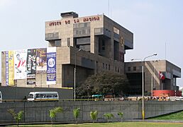
The Museo de la Nación houses thousands of artifacts spanning the entire span of human occupation in Peru.
-
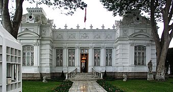
The Museo Pedro de Osma houses artistic objects dating from the 16th to 18th centuries, including paintings, sculptures, altarpieces, silverware, Huamanga stone carvings, furniture and other objects from regions with an ancient Andean artistic tradition.
-
Larco Museum is a privately owned museum of pre-Columbian art that is housed in an 18th-century vice-royal building built over a 7th-century pre-Columbian pyramid.
-
National Museum of Archaeology, Anthropology and History of Peru is the largest and oldest museum in Peru.


Delicious Food

Lima is known as the Gastronomical Capital of the Americas. Because many different people have moved to Lima over time, its chefs have mixed Spanish, African, European, Chinese, and Japanese cooking styles. Lima's food includes Creole food, Chifa (Peruvian-Chinese), Cebicherias, and Pollerias.
Lima is home to Central Restaurante, which was named the Best restaurant in the world in 2023!
In the 21st century, Lima's restaurants became famous around the world. In 2007, the Peruvian Society for Gastronomy (APEGA) was created to promote Peruvian food. One of their projects was to start Mistura, the largest food festival in Latin America. It happens every September and brings together restaurants, food producers, and chefs.
Several Lima restaurants have been recognized among The World's 50 Best Restaurants. In 2023, Central was named the best in the world.

Ceviche is Peru's national dish. It's made from raw fish marinated in lime juice with salt, garlic, onions, and hot peppers. You can find different types of ceviche, like black-oyster ceviche or trout ceviche.
Religion in Lima

When the Spanish arrived in Peru, they brought the Catholic religion. Before that, the local people had their own beliefs. Over time, the Catholic faith became very important in Lima. Saints like Rose of Lima and Martín de Porres lived here.
Lima is the seat of the Archdiocese of Lima, which is one of the oldest in the Americas. The city also has mosques, synagogues, a temple for the Church of Jesus Christ of Latter-day Saints, and Buddhist temples.
Most people in Lima are Catholic (about 82.8%). The procession of the Señor de Los Milagros (Lord of Miracles) is a very important Catholic event in Lima. It happens every October, and a special image from colonial times is carried through the streets.
Sports in Lima


Lima has many sports venues for football, golf, volleyball, and basketball. A popular local sport is fronton, which is similar to squash. There are seven international-class golf courses. Equestrianism (horse riding) is also popular.
The most popular sport in Lima is football. The city has several professional football teams. The historic Plaza de toros de Acho in the Rímac District is the oldest bullring in the Americas. It hosts bullfights from October to December, and also concerts and other events.
Lima has hosted major sports events, including the 2004 Copa América and the 2019 Pan American Games. It will also host the 2027 Pan American Games.
| Club | Sport | League | Venue |
|---|---|---|---|
| Peruvian Institute of Sport | Various | Various | Estadio Nacional (Lima)
Villa Deportiva Nacional |
| Club Universitario de Deportes | Football | Peruvian Primera División | Estadio Monumental "U" |
| Alianza Lima | Football | Peruvian Primera División | Estadio Alejandro Villanueva |
| Sporting Cristal | Football | Peruvian Primera División | Estadio Alberto Gallardo |
| Deportivo Municipal | Football | Peruvian Segunda División | Estadio Iván Elías Moreno |
| CD Universidad San Martín | Football | Peruvian Segunda División | Estadio Iván Elías Moreno |
| Regatas Lima | Various | Various | Regatas Headquarters Chorrillos |
| Real Club Lima | Basketball, Volleyball | Various | San Isidro |
How Lima is Organized

Lima is made up of 31 busy districts. Each district has its own local mayor, and there's also a Mayor of Lima who oversees all of them.
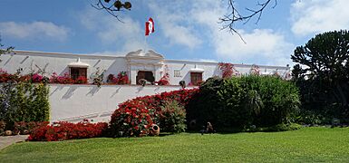
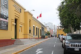
The Historic Centre of Lima is in the Cercado de Lima district. This area has many old colonial buildings, the Presidential Palace, and Lima's Chinatown.
The San Isidro District is Lima's financial center. It's where many important businesses are located. It also has beautiful parks, like Parque El Olivar, which has olive trees brought from Spain centuries ago.
Miraflores is another upscale district with luxury hotels, shops, and restaurants. It has many parks and green spaces. Larcomar, a shopping and entertainment center, is built on cliffs overlooking the Pacific Ocean.
Other wealthy districts include La Molina, San Borja, and Santiago de Surco. Middle-class districts include Jesús María, Lince, and Magdalena del Mar.
The most populated districts are in Northern and Southern Lima. These areas are home to many people who moved from the Andean regions. Shopping malls like Megaplaza are in these areas.
Barranco, next to Miraflores, is known as the city's bohemian district. Many writers and artists have lived there. It has restaurants, music venues, and charming old houses.
Learning in Lima

Lima has the most universities and schools in South America. The National University of San Marcos, founded in 1551, is the oldest continuously operating university in the Americas.
Other important public universities include the Universidad Nacional de Ingeniería (for engineering) and the Universidad Nacional Federico Villarreal. The Pontifical Catholic University of Peru is the oldest private university, founded in 1917.
Lima has over 8,000 elementary and high schools, both public and private, teaching more than 1.5 million students. More students in Lima attend high school and preschool compared to the national average.
Students in Peru take a test called "Evaluacion Censal de Estudiantes" (ECE) in second and fourth grade. This test checks reading and math skills. Lima's students generally perform better than the national average on these tests.
About 23% of men and 20% of women in Lima have completed university education. The average person in Lima goes to school for about 11.1 years.
Getting Around Lima
Air Travel

Lima's main airport is Jorge Chávez International Airport (LIM), located in Callao. It's the largest airport in Peru and a major hub for flights in Latin America. It's the home base for most Peruvian airlines. The airport is currently being expanded with a new terminal and runway, aiming to handle 40 million passengers.
Roads and Highways
Lima is a key stop on the Pan-American Highway. Three major highways start in Lima:
- The Northern Panamerican Highway: Goes north to Ecuador, connecting many coastal cities.
- The Central Highway (Carretera Central): Connects eastern Lima with cities in central Peru.
- The Southern Panamerican Highway: Goes south to Chile, connecting southern coastal areas.
Lima has a main bus terminal that connects to cities across Peru and other countries.
Sea Travel
.jpg)
The port of Callao is Lima's main port and one of the largest in Latin America. It handles almost all of Lima's sea transport. A new, larger port is being built north of Lima in Chancay, which is expected to be the biggest in South America.
Train Travel

Lima is connected to the central Andean region by the Ferrocarril Central Andino railway. This line goes through several departments, connecting cities like Huancayo and La Oroya. Lima's main train station is the Desamparados station.
Public Transportation

Lima's roads mostly use large divided avenues instead of freeways. The city has a network of nine freeways. Most people in Lima use public transportation (about 75.6%).
The urban transport system includes over 300 bus routes. Taxis are common and usually unmetered, so you agree on the price before your ride.
The Integrated Transport System (SIT) is a new bus system designed to make public transport better. It aims to reduce the number of routes and replace older buses.
Metropolitan Transport System

The El Metropolitano is a modern bus system with special lanes. It helps reduce travel times and air pollution. It runs on natural gas. The first phase of this system opened in 2010.
Lima Metro

The Lima Metro is planned to have six lines. As of 2024, two lines are running, and a third is being built. Line 1 has 26 stations and runs for almost 35 kilometers (22 mi). It started operating in 2012. Line 2 is also expanding, and parts of Line 4 will connect to the airport.
Traffic and Biking

Lima has a lot of traffic, especially during busy hours. The city has over 1.3 million vehicles.
To encourage biking, the government offers incentives for districts to build bike routes. In 2012, there were 71 kilometers (44 mi) of bike lanes. The San Borja district was the first to start a bike-sharing program.
Challenges in Lima
The "Wall of Shame"
In the 1980s, many people moved to Lima from rural areas to escape conflict. These new arrivals, often very poor, built simple homes. In response, some wealthier neighborhoods built tall walls, sometimes with barbed wire, to separate themselves. These walls are now a source of tension. Many people from the poorer areas cross these walls daily to work in the richer neighborhoods, often as gardeners or domestic workers.
Environment Concerns

Air Pollution
Lima suffers from air pollution. Tiny particles from car exhaust and factories float in the air. These fine particles can harm people's lungs if inhaled. Lima has even built billboards that act as air purifiers.

Water Quality
The water supply in Lima is monitored for minerals like lead. While the levels are generally within safe limits, the city faces challenges with water access.
Waste Management
Each person in Lima produces about 0.7 kg (1.5 lbs) of solid waste per day. However, district municipalities only collect about 67% of this waste. The rest often ends up in unofficial landfills, rivers, or the ocean.
Access to Basic Services
Most homes in Lima (93%) have access to water supply and sewage systems (92%). Almost all homes (99.6%) have electricity. However, some areas only have water for a few hours a day. About 1.5 million people in Lima do not have access to drinking water in their homes. They have to buy water from tankers, which isn't always safe. This water problem is worse in the poorer areas of the city. In wealthy districts, people use much more water per day than in poorer neighborhoods.
Safety in the City

How safe people feel varies a lot by district. For example, people in San Isidro feel very safe, while those in Rimac feel less safe.
Overall, about 40% of people in Lima over 15 years old have been victims of a crime. The most common crimes are thefts. The districts with the highest crime rates include Rimac and San Juan de Lurigancho. The safest districts are Lurin, San Borja, and Miraflores.

While the police force is controlled by the national government, each district in Lima also has a community policing group called Serenazgo. The number of Serenazgo officers and resources varies greatly by district. People in San Isidro and Miraflores are generally very satisfied with Serenazgo, while those in other districts are less so.
Notable People
Sister Cities
Lima is twinned with many cities around the world, meaning they have a special friendly relationship.
- Akhisar, Turkey
- Asunción, Paraguay
- Austin, United States
- Beijing, China
- Bogotá, Colombia
- Bordeaux, France
- Brasilia, Brazil
- Buenos Aires, Argentina
- Caracas, Venezuela
- Cleveland, United States
- Guadalajara, Mexico
- Karaçoban, Turkey
- Kyiv, Ukraine
- Madrid, Spain
- Mexico City, Mexico
- Miami, United States
- Montreal, Canada
- Pescara, Italy
- Santa Ana, Costa Rica
- São Paulo, Brazil
- Shanghai, China
- Stamford, United States
- Taipei, Taiwan
- Tegucigalpa, Honduras
Images for kids
-
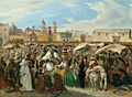
Market in the Plaza of the Inquisition (Lima) by Johann Moritz Rugendas, ca. 1843
-
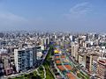
Lima in 2013
-
Pueblos jóvenes on the outskirts of Lima in 2015. Today, many of them are consolidated.
_Rugendas.jpg)


See also
 In Spanish: Lima para niños
