
Lima metropolitan area facts for kids
Quick facts for kids
Lima Metropolitan Area
|
|
|---|---|
 |
|
| Country | |
| Region | Lima |
| Province | Lima and Callao |
| Core city | Lima |
| Population
(estimated 2022)
|
|
| • Total | 11,804,609 |
| Time zone | UTC-5 (PET) |
The Lima Metropolitan Area (also known as Lima Metropolitana) is a huge urban area in Peru. It is formed by two main areas growing together: Lima and Callao. Lima is the capital city of Peru.
This metropolitan area is the largest in Peru. It is also one of the biggest in all of the Americas. In fact, it is among the thirty largest metropolitan areas in the entire world! The two cities started to grow into each other around the 1980s.
The Lima Metropolitan Area is divided into five main parts. These are Lima Norte (North Lima), Lima Sur (South Lima), Lima Este (East Lima), Central Lima, and Callao. In 2020, it was estimated that over 11 million people lived here.
History of Lima and Callao
Founding of the Cities
The city of Lima was founded by Spanish settlers. This happened on January 18, 1535. They called it "The City of the Kings." Just two years later, in 1537, the important port city of Callao was also founded.
Francisco Pizarro officially started Lima at its main square. This place is now known as the Plaza Mayor. Lima quickly became the most important city in all of South America.
Growing Together
The city of Callao was also very important. For hundreds of years, it was the only port in all of Spanish South America allowed to ship goods around the world. Lima and Callao were once separated by a desert. However, their connection was always vital.
They were finally linked by a railroad in the 1800s. The two cities kept growing bigger and bigger. Eventually, they grew so much that they joined together. This created the large metropolitan area we see today.
Lima Today
Modern Life in the Metropolis
Today, Lima is the most important big city in Peru. It is also a key city in the Andean region. The main financial area is San Isidro. Here, you will find many business centers, tall skyscrapers, and shops.
If you are looking for nightlife, Miraflores and Barranco are popular areas. Some parts of the city are very lively. You might hear music playing at night in these places.
Cultural Differences in Districts
Different areas of Lima have their own unique feel. This is because they were settled at different times. They also have different economic levels and people have moved there from all over Peru.
The downtown area is very historic. It is not like the modern downtowns in many other big cities. Instead, it has many old cathedrals and churches. These were built during the time of Spanish rule.
New Communities and Growth
In the late 1900s, Lima grew very fast. Many people moved there from other regions of Peru. These new residents often created new communities. They were called pueblos jovenes (young towns) and asentamientos humanos (human settlements).
These new towns are similar to the favelas in Brazil, but usually smaller. Many of them started without running water or electricity. The city found it hard to provide services for everyone. However, many of these communities have grown. Places like Comas and Villa El Salvador are now modern districts. People living there have found the better life they hoped for.
Geography of the Area
Size and Location
The Lima Metropolitan Area covers a large space of about 2,819 square kilometers (1,088 square miles). It stretches along the Pacific coast for almost 200 kilometers (124 miles). It starts in the north at Ancón and ends in the south at Pucusana.
Three rivers flow through this area: the Rímac, Chillón, and Lurín rivers. The metropolitan area includes 50 districts in total. Forty-three are in Lima Province and seven are in Constitutional Province of Callao.
Landscape and Divisions
Most of the area is located in a desert. The eastern part is found at the base of the Andes mountains. Lima is actually the world's second-largest desert city, after Cairo in Egypt.
The Lima metropolitan area is informally divided into five main sections:
- Northern Lima
- Southern Lima
- Eastern Lima
- Central Lima
- Callao
Getting Around Lima
Connecting Cities
Today, Lima and Callao have grown so close that you can barely tell where one ends and the other begins. Only signs mark their borders. Many streets and highways connect these two cities.
Public Transport Options
- Taxicabs
- Taxis in Lima come in different qualities and prices.
- You can usually stop a taxi on the street.
- You can also call private taxi companies to pick you up.
- New laws have helped improve taxis by requiring newer cars. This also helps reduce air pollution.
- Bus
- Many bus companies offer rides to other cities in Peru.
- The quality of buses varies a lot. You can find luxury express buses or older, crowded local buses.
- Mass-transit systems:
- El Metropolitano: This is a modern bus system that runs above ground. It connects many parts of the city. It goes from Chorrillos in the south to the border of Independencia and Comas in the north. This includes the downtown area, business districts, and residential areas.
-
- Lima Metro: In 2010, the government started building Line 1 of the Lima Metro again. This line is an elevated train system. It will be about 22.5 kilometers (14 miles) long. It connects the Atocongo Bridge to downtown Lima. The first part of Line 1 began operating in July 2011.

- Air transport
- Lima's main airport is Jorge Chávez International Airport.
- It is located in Callao, about 11 kilometers (7 miles) northwest of the city center.
- This airport is the main gateway for people flying into and out of Lima.
Where People Live: Population Distribution
Here's how the population is spread out across the different areas of the Lima metropolitan area:
- Lima Norte (North Lima): 26% of the total population. This includes districts like Ancón, Carabayllo, Comas, Independencia, Los Olivos, Puente Piedra, Rimac, San Martin de Porres, Santa Rosa.
- Lima Este (East Lima): 12% of the total population. This includes districts like Ate, Cieneguilla, Chaclacayo, El Agustino, La Molina, Lurigancho, San Juan de Lurigancho, San Luis, Santa Anita.
- Lima Sur (South Lima): 20% of the total population. This includes districts like Barranco, Chorrillos, Lurín, Pachacamac, Pucusana, Punta Hermosa, Punta Negra, San Bartolo, San Juan de Miraflores, Santa María del Mar, Villa el Salvador, Villa María del Triunfo, Chilca.
- Central Lima: 11% of the total population. This includes districts like Breña, La Victoria, Lima, Lince, Pueblo Libre, San Miguel.
- Residential Lima: 19% of the total population. This includes districts like Jesús María, Magdalena, Miraflores, San Borja, San Isidro, Santiago de Surco, Surquillo.
- Callao: 12% of the total population. This includes districts like Bellavista, Callao District, Carmen de la Legua Reynoso, La Perla, La Punta, Ventanilla District.
How Lima's Population Has Grown
The maps below show how the Lima/Callao metropolitan area has grown over many years. The first map shows the population in 1535, when Lima was founded. The last map shows the population in 2006.
| Population of the Lima metropolitan area (1940–2017) |
|---|
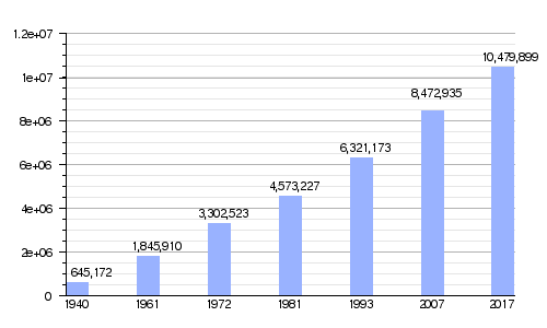 |
| Sources: Population 1940, 1961, 1972, 1981, 1993, 2007 2017 |
Lima as a Future Megacity
The Lima metropolitan area officially became a megacity in 2017. A megacity is a metropolitan area with more than ten million people. Lima was the first megacity in the Andean States. It was also the fourth in South America and the seventh in the Americas.
According to a group called the Globalization and World Cities Research Network, Lima is a "Beta +" city. This means it is a very important global city. It is just one step away from being in the top "Alpha" category.
See also
 In Spanish: Lima Metropolitana para niños
- List of metropolitan areas of Peru
- Lima
- Callao
- Peru
- Metropolitan area
- List of Latin American cities by population
