
Chungará Lake facts for kids
Quick facts for kids Chungará Lake |
|
|---|---|
| Chungara | |
.jpg)
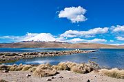
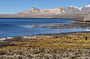
The volcano Parinacota rises over Chungará
|
|

Chungará Lake
Location in Chile
|
|
| Coordinates | 18°14′S 69°09′W / 18.233°S 69.150°W |
| Primary inflows | Chiefly Río Chungara |
| Primary outflows | Evaporation and seepage |
| Catchment area | 260 square kilometres (100 sq mi) |
| Max. length | 8.75 kilometres (5.44 mi) |
| Surface area | 21.5–22.5 square kilometres (8.3–8.7 sq mi) |
| Max. depth | 26–40 metres (85–131 ft) |
| Surface elevation | 4,517 metres (14,820 ft) |
Chungará Lake is a beautiful lake located in the far north of Chile. It sits very high up, at about 4,517 metres (14,820 ft) (that's over 14,800 feet!) in a high plain called the Altiplano. This amazing lake is part of the Lauca National Park.
The lake covers an area of about 21.5–22.5 square kilometres (8.3–8.7 sq mi) (around 8.3 to 8.7 square miles). Its deepest parts are about 26–40 metres (85–131 ft) (85 to 130 feet) deep. Water flows into Chungará Lake mainly from the Río Chungara and other small streams. Most of its water leaves by evaporation (turning into vapor and rising into the air). Some water also slowly seeps into the nearby Laguna Quta Qutani.
Chungará Lake was formed a long time ago, between 8,000 and 17,000 years ago. This happened when the Parinacota volcano partly collapsed. The huge amount of rock and dirt from the collapse blocked the Lauca River, creating the lake. Since then, the lake has slowly grown bigger.
Contents
What's in a Name?
The name Chungará comes from the Aymara language, spoken by native people in the Andes. It has a few possible meanings. One idea is that it comes from Chunka, which is a type of bush or moss. The ending ra means "covered by." So, it could mean "covered by moss."
Another meaning comes from Chunkha, which means "beard." With the ra ending, it could mean "bearded." This meaning is linked to an old story. The myth tells of a bearded man who came to the area and destroyed a community with fire.
Where is Chungará Lake?
Chungará Lake is in the very northern part of Chile. It is also quite close to the border with Bolivia. As mentioned, it sits at a high elevation of 4,517 metres (14,820 ft) in the Chilean Altiplano. This makes it one of the highest lakes in the world! It's also the second-largest high-altitude lake in the Altiplano, after Lake Titicaca.
The lake is part of the Lauca National Park. This park is a special protected area recognized both in Chile and around the world. There's a park refuge near the lake's western side. You can also find a small boat area (marina) and a pumping station on the lake's northwest side. Chile Route 11 (a road) runs along the southern and western edges of Chungará Lake.
The lake is about 8.75 kilometres (5.44 mi) (5.4 miles) wide. It has an uneven shape, with two large bays in the northeast and south. A narrower bay is in its northwest corner. The deepest part of the lake, about 26 metres (85 ft)-40 metres (130 ft) (85-130 feet) deep, is in the northwest. The northern and western shores are steep. The southern and eastern shores are much flatter. The eastern shore has a large fan-shaped deposit of sediment. The southern shore has sediments from the Río Chungara. About 4 kilometres (2.5 mi) (2.5 miles) northwest of Chungará Lake are the Lagunas Cotacotani.
The volcanoes Parinacota (6,342 metres (20,807 ft) or 20,807 feet) and Ajoya (5,293 metres (17,365 ft) or 17,365 feet) are north and west of the lake. The northern shore of the lake was formed by hardened lava flows from Parinacota. Another volcano, Quisiquisini (5,516 metres (18,097 ft) or 18,097 feet), is on the eastern shore. Farther south is the 6,063 metres (19,892 ft) (19,892 feet) high Guallatiri volcano.

How Water Moves In and Out
The water temperature in Chungará Lake changes throughout the year. It's warmest in March, around 13.5 °C (56.3 °F) (56.3°F). It's coldest in January, around 3.5 °C (38.3 °F) (38.3°F). The water at the bottom of the lake stays between 6.4–6.2 °C (43.5–43.2 °F) (43.5-43.2°F). The lake's water level changes by about 0.5 metres (1 ft 8 in) (1.6 feet) between seasons. Larger changes of 3–2 metres (9.8–6.6 ft) (10-6.5 feet) have also been seen.
Today, the lake's water levels are the highest they have ever been. The lake has generally gotten deeper over time. There have been some periods when the water level was lower. But for the last 5,000 years, the lake levels have been high.
Chungará Lake is part of a large area called a watershed, which covers 260 square kilometres (100 sq mi) (100 square miles). This area is surrounded by snow-covered volcanoes. The biggest river flowing into the lake is the Río Chungara. It brings about 4/5 of the water to the lake. This river starts at Guallatiri volcano. Other smaller streams like Chachapay, Mal Paso, Ajata, and Sopocalane also feed the lake. Some of these streams form small river deltas where they enter the lake. Springs also add water from the western and northern shores.
Chungará Lake has no visible river flowing out of it. Most of its water Template:Evaporates into the air. Some water also slowly seeps into the ground. This underground water eventually reaches the Cotacotani Lakes. Over time, less water has seeped out because silt (fine dirt) has built up in the ground. The Cotacotani Lakes then drain into the Lauca River.
The total amount of water in Chungará Lake is about 0.426 cubic kilometres (0.102 cu mi) (0.1 cubic miles). The lake's water is well mixed and very clear. Sunlight can reach most of the lake floor. The water is a little bit alkaline (the opposite of acidic) and salty. Strong currents move the water around on the surface.
How the Lake Was Formed
Chungará Lake was formed by volcanic activity. A huge part of the Parinacota volcano collapsed. This collapse blocked an old river called the Rio Lauca. This created Chungará Lake between 8,000 and 17,000 years ago. The collapse involved about 6 cubic kilometres (1.4 cu mi) (1.4 cubic miles) of rock and debris. It covered about 140 square kilometres (54 sq mi) (54 square miles) with this material. Before the collapse, the lake area was just river sediments from the Rio Lauca. When the river was blocked, water built up and formed the lake.
Volcanoes have been active in this area for a very long time. Volcanoes like Parinacota, Ajoya, and Quisiquisini grew on older rock formations. Only Parinacota has been active more recently, leaving ash (called tephra) in the lake.
Weather Around the Lake
The average temperature at Chungará Lake is about 4.2 °C (39.6 °F) (39.6°F). During the day, temperatures can range from 20–12 °C (68–54 °F) (68-53.6°F). At night, they can drop to 3 – −10 °C (37–14 °F) (37.4-14°F). The climate around the lake is dry. The amount of rain each year is about 330 millimetres per year (0.41 in/Ms) (13 inches). This is much less than the amount of water that evaporates.
Most of the rain happens in the summer. This is when moisture comes from the Amazon and the Atlantic Ocean. This rainy season is sometimes called the "Bolivian Winter." The amount of rain can change depending on a weather pattern called "ENSO" (El Niño-Southern Oscillation). The area also gets a lot of sunlight.
People and the Lake
Aymara people live in the area around Chungará Lake. They raise animals like alpacas, cattle, llamas, and sheep. They live on farms and in shelters for herders.
-
The marina of Chungará Lake
-
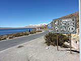
Road and roadsign on Chungará Lake
-
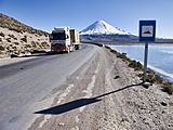
Road on Chungará Lake
.jpg)

.jpg)
Looking After the Lake
In the 1970s, there was a plan to pump water from Chungará Lake to the Azapa Valley. This was to help with irrigation (watering crops). But this project stopped quickly. The lake's water levels dropped, and the plants and animals in the lake were harmed. A canal was built to move water to the Laguna Cotacotani, which feeds into the Azapa system.
Many environmental groups were against this project. In 1985, Chile's highest court made an important decision. They said that the government had to consider international agreements about protecting nature. They stopped the use of Chungará Lake's waters for irrigation. This meant the region had to find other ways to get water for its growing needs.
Another problem around Chungará Lake is rubbish. A lot of waste is thrown away by drivers on the road between Chile and Bolivia. The Chilean government has organized clean-up efforts to remove some of this waste.
Plants and Animals
Chungará Lake is home to many different kinds of plants and animals. Around the lake, you can find wetlands called bofedales. Other plants in the area include small Polylepis trees, shrubs, and tall tussock grasses.
The plants along the shoreline attract many birds. You might see Andean gulls, Chilean flamingos, crested ducks, giant coots, and Puna plovers.
-
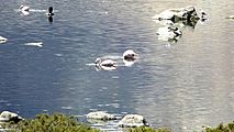
Birdlife, including Chilean flamingo, at Chungará Lake
-
Shoreline vegetation and landscape

.jpg)
Because the water is so clear, many aquatic plants grow in Chungará Lake. They are especially noticeable on the southern shores. Here you can find plants like Myriophyllum elatinoides and Potamogeton filifolius. The shores are also home to amphibians like Rhinella, Pleurodema, and Telmatobius. You can also find molluscs and small worms called turbellaria.
The tiny plants floating in the lake (called phytoplankton) are mostly diatoms in winter. In summer, they are mostly green algae. Other types of algae include large Cladophora and Nostoc, and smaller ones like Botryococcus braunii. Tiny animals floating in the water (called zooplankton) include copepods and cladocera. You can also find groups of microbes (very tiny living things) on the lake's shores.
Fish in the Lake
Chungará Lake has two special types of fish that are found nowhere else. These are the pupfish Orestias chungarensis and the catfish Trichomycterus chungaraensis.
The Orestias chungarensis fish in Chungará Lake are related to other Orestias species. These relatives are found in other water bodies in the Lauca National Park and nearby salt flats. This shows that these water areas were once connected by an ancient lake. The Orestias fish in Chungará Lake live at very high elevations, over 4.5 kilometres (2.8 mi) (14,760 feet). This makes them among the highest-living fish in the world! Sadly, these fish are considered threatened species (meaning they are at risk of disappearing).
The rainbow trout also lives in the lake. However, it is considered an invasive species here. This means it's not native to the lake and can cause harm. Rainbow trout eat the threatened Orestias fish. Because of this, the Chilean government has considered plans to remove the rainbow trout from the lake.
See also
 In Spanish: Lago Chungará para niños
- K'isi K'isini
