Lauca River facts for kids
Quick facts for kids Lauca River |
|
|---|---|
 |
|
| Countries | |
| Departments (BO) | |
| Regions (CL) | |
| Physical characteristics | |
| Main source | Parinacota wetlands Parinacota Province 4,350 m (14,270 ft) |
| River mouth | Coipasa Lake Sabaya Province |
| Length | 225 km (140 mi) |
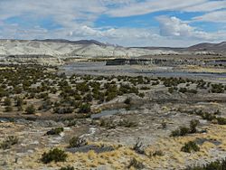
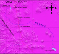
The Lauca River is a special river that flows through two countries: Chile and Bolivia. It starts high up in the mountains, in a flat area called the Altiplano in Chile's Arica and Parinacota Region. From there, it travels across the huge Andes mountain range and eventually ends up in Coipasa Lake in Bolivia.
Contents
The Lauca River's Journey
Where the River Starts
The top part of the Lauca River flows through Lauca National Park in Chile. This area is in the Parinacota Province. The river gets its water from a group of lakes called Quta Qutani. The water flows from these lakes into the Lauca through a smaller river called the Desaguadero River.
In this region, there are special marshy areas known as the Parinacota wetlands. Many small streams join together here. The Desaguadero River is the most important one. The amount of water flowing in it changes, but on average, it's about 260 liters per second.
River's Path Through Mountains
From where it begins in the Parinacota wetlands, the Lauca River first flows towards the west. However, a part of the Andes mountains, called the Cordillera Central, blocks its way. The river can't go through these mountains, so it has to turn and flow south instead.
Near the Wallatiri volcano, the Lauca River changes direction again. This time, it turns eastward and crosses from Chile into Bolivia. This happens at a place called Macaya, where the river is about 3,892 meters (12,769 feet) above sea level. At this point, about 2.6 cubic meters (92 cubic feet) of water flow through it every second. In Chile, the river drains an area of about 2,350 square kilometers (907 square miles).
Flowing into Bolivia
Once the Lauca River enters the Bolivian Altiplano, it collects more water. Other rivers, like the Sajama and Coipasa rivers, join it. This makes the Lauca River much bigger, with up to 8 cubic meters (282 cubic feet) of water flowing per second.
After collecting these waters, the river turns south. Finally, it empties into Coipasa Lake. This lake is very close to a large salt flat called the Salar de Coipasa.
A River's Importance and History
Using the River's Water
In the 1930s, the Chilean government started using some of the Lauca River's water. They wanted to use it for irrigation in the Azapa Valley. Irrigation means bringing water to dry land to help crops grow.
A Disagreement Over Water
This use of the river's water led to a disagreement with the Bolivian government. Bolivia said that Chile was changing the flow of an international river, which means a river that belongs to more than one country. Chile replied that they were not changing the main river's path. They said they were only using water from the Parinacota wetlands, which they believed did not affect the total amount of water flowing into Bolivia.
This disagreement started in 1939 and caused some tension between the two countries. The issue continued to be a diplomatic topic until the 1960s.
See also
 In Spanish: Río Lauca para niños
 | Toni Morrison |
 | Barack Obama |
 | Martin Luther King Jr. |
 | Ralph Bunche |


