
Guallatiri facts for kids
Quick facts for kids Guallatiri |
|
|---|---|

Fumarole activity in the crater of Guallatiri
|
|
| Highest point | |
| Elevation | 6,071 m (19,918 ft) |
| Naming | |
| Native name | Error {{native name}}: an IETF language tag as parameter {{{1}}} is required (help) |
| Geography | |

Guallatiri
Location in Chile
|
|
| Location | Putre, Parinacota Province, Arica y Parinacota, Chile |
| Geology | |
| Age of rock | Pleistocene-Holocene |
| Mountain type | Volcano |
| Volcanic field | Nevados de Quimsachata |
| Last eruption | 1960 |
Guallatiri is a tall volcano in Chile, standing at about 6,071 meters (19,918 feet) high. It is located in the northern part of Chile, southwest of a group of volcanoes called Nevados de Quimsachata. Guallatiri is a type of volcano known as a stratovolcano, which means it's built up of many layers of hardened lava, ash, and rock. You can often see steam and gases, called fumaroles, coming out near its top.
This volcano has been active many times in history, with its last known eruption in 1960. Even today, it still shows signs of activity with ongoing steam and small earthquakes. Because of this, minerals like sulfur are often found on its slopes. The top of Guallatiri is covered by an ice cap, which is a large area of ice. This ice cap has been getting smaller over the last century. Guallatiri is part of the Lauca National Park and is watched closely by a Chilean government agency called SERNAGEOMIN to keep people safe.
Contents
What's in a Name?
The name Wallatiri comes from the Aymara language. It means "plenty of Andean goose", because these birds are often seen in the area. The volcano is also sometimes called Punata, Huallatiri, or Huallatire. The first person to climb Guallatiri was a German-Bolivian geologist named Friedrich Ahlfeld in 1926. Climbing the volcano is considered fairly easy, but the gases coming from the top can be dangerous.
Where is Guallatiri?
Guallatiri is located in the Putre area of the Arica and Parinacota Region in Chile. It's south of Lake Chungara and about 4 kilometers (2.5 miles) west of Cerro Capurata. Cerro Capurata is part of a chain of volcanoes called the Nevados de Quimsachata, which also includes Humurata and Acotango. Guallatiri is sometimes thought of as part of this group. The volcano is also part of the larger Western Cordillera, which forms the western edge of the high Altiplano plateau.
The small town of Guallatiri is about 9.5 kilometers (5.9 miles) southwest of the volcano. It has a cemetery, a church from the 1600s, and a shelter run by the National Forest Corporation. Other small towns nearby include Ancuta, Carbonire, and Churiguaya. These towns are very small, with less than 25 people each. The main city of Putre is about 55 kilometers (34 miles) north, and the city of Arica on the Pacific Ocean is 130 kilometers (81 miles) further west. People in the area make a living from farming, raising animals, tourism, and climbing the volcano. The border between Bolivia and Chile is also very close to Guallatiri.
The Volcano's Shape
Guallatiri is a composite volcano or stratovolcano. It has a cone shape with a lava dome or a complex of lava at its top. A lava dome is a mound of thick, sticky lava that piles up around a volcano's vent. The volcano rises about 1.7 kilometers (1.1 miles) above the land around it and covers an area of about 85 square kilometers (33 square miles).
The volcano is made up of lava domes, lava flows, tephra (rock fragments), and volcanic ash. Thick lava flows spread out in all directions from the volcano, especially on its northern and western sides, reaching up to 8 kilometers (5.0 miles) long. These lava flows can be very thick, up to 230 meters (750 feet). There are also deposits of block-and-ash flows on the southern and southwestern sides. Tephra deposits are mostly found on the eastern and southern parts of Guallatiri.
On the southern side of the volcano, there are two lava domes called Domo Tinto and Domo Sur. Domo Tinto is about 100 meters (330 feet) wide and 100 meters (330 feet) high, while Domo Sur is 120 meters (390 feet) thick and 750 meters (2,460 feet) wide.
Guallatiri also has both cold and hot springs. This means that underground water mixes with the hot rocks from the volcano. One hot spring at Chiriguaya, on the northwestern base of Guallatiri, has bubbling pools with temperatures of 48 degrees Celsius (118 degrees Fahrenheit). Several streams flow down from the mountain, eventually reaching Lake Chungara and the Rio Lauca.
Ice on the Volcano
Above 5,500 to 5,800 meters (18,000 to 19,000 feet) high, Guallatiri is covered with ice. As of 2017, a small ice cap on the volcano covered an area of about 0.796 square kilometers (0.307 square miles). This ice cap has been shrinking quickly, breaking into several smaller pieces of ice. The heat from the volcano's fumaroles might be making the ice melt even faster.
Long ago, much larger areas of Guallatiri were covered by glaciers. These ancient glaciers left behind deposits of rock and debris called moraines. Unlike most places in the world where glaciers were largest around 21,000 to 19,000 years ago, the glaciers on Guallatiri reached their biggest size between 13,500 and 8,900 years ago. This was because the climate in this region was more affected by how much moisture was available than by how cold it was.
How the Volcano Formed
Off the western coast of South America, a large piece of the Earth's crust called the Nazca Plate is slowly sliding underneath the South America Plate. This process, called subduction, happens at a rate of about 7 to 9 centimeters (2.8 to 3.5 inches) per year. This movement is what causes the volcanoes in the Central Volcanic Zone (CVZ), where Guallatiri is located. The CVZ is a 1,500-kilometer (930-mile) long chain of volcanoes that stretches across southern Peru, northern Chile, western Bolivia, and northwestern Argentina. It has about 58 volcanoes that could be active, with 33 of them in Chile.
Guallatiri sits on top of older volcanic and sedimentary rocks. The rocks that make up Guallatiri itself are mostly dacite, but also include andesite and rhyolite. These rocks contain various minerals like amphibole, apatite, biotite, and plagioclase. Sometimes, pieces of darker, more basic rocks are found within Guallatiri's rocks, suggesting that different types of molten rock mixed together deep inside the volcano.
The steam and gases coming from Guallatiri's fumaroles have deposited many minerals, such as sulfur, gypsum, and quartz. Less common minerals like galena and pyrite are also found. The sulfur deposits can be yellow, orange, or red. These deposits sometimes contain other elements like arsenic, iodine, and mercury. In 1942, it was estimated that the volcano had about 800,000 tons of sulfur ore. The volcano might also be a source of arsenic pollution in the area.
Plants, Animals, and Climate

Guallatiri is located inside the Lauca National Park. The wet areas, called bofedales, around Guallatiri are very important for the region. Many plants grow here, including Arenaria rivularis and Oxychloe andina.
Many animals live around the volcano. Birds include the Andean flamingo, Andean gull, and condor. Mammals like the alpaca, llama, and vicuña are also found here. There are even woodlands formed by a tree called Polylepis tarapacana on Guallatiri. These are the highest woodlands in the world! The very top parts of the mountain are mostly rocks with only a few small plants.
The region around Guallatiri has a tundra climate, which means it's cold and dry. Most of the rain falls during the summer months. This moisture mainly comes from the Atlantic Ocean and the Amazon rainforest. Scientists have even studied the tree rings of Polylepis tarapacana trees on Guallatiri to learn about past climates.
Volcano's Past Eruptions

Guallatiri started being active about 710,000 years ago, or possibly between 262,000 and 130,000 years ago. The volcano has been growing ever since, through the Pleistocene and Holocene periods. The older volcanoes nearby, Humurata and Acotango, are very worn down, while Capurata is better preserved.
Scientists believe that large eruptions, similar to the big Lascar eruption in 1993, might have happened at Guallatiri in the past. The biggest eruption in recent times was about 2,600 years ago. This was a Plinian eruption, which means it was a very powerful explosion that sent a tall column of ash and gas high into the sky. This eruption left thick layers of ash and pumice (lightweight volcanic rock) southwest of the volcano. Non-explosive eruptions also happened, like the one that formed the Domo Tinto lava dome about 5,000 years ago.
Deposits from pyroclastic flows, which are fast-moving currents of hot gas and volcanic debris, have been found up to 10 kilometers (6.2 miles) away from Guallatiri. Lahars, which are mudflows made of volcanic material mixed with water, have also been found on the southern sides of the volcano. Lahars can form when volcanic material mixes with melting ice or heavy rainfall.
Recent Activity
Guallatiri is the second most active volcano in northern Chile, after Lascar. It has had many small explosive eruptions since the 1800s, which produced thin layers of ash. However, its eruption history is not very well known. Some recorded eruptions with a Volcanic Explosivity Index of 2 (a moderate eruption) happened in 1825, 1913, July 1959, and December 1960. Other less certain eruptions were reported in 1908, 1862, 1864, 1870, 1902, 1904, and 1987.
In December 1985, more steam than usual was seen coming from the volcano. In May 2015, SERNAGEOMIN raised the volcano alert level because of increased earthquake activity and a 200-meter (660-foot) high plume (cloud of gas and ash) appeared over the volcano. The alert level was lowered again in July when the activity decreased.
Small earthquakes and occasional groups of earthquakes, called seismic swarms, are recorded at Guallatiri. For example, one swarm was caused by a large earthquake in Peru in 2001. Satellite images have not shown any signs that the volcano's shape is changing.
Fumaroles and Gases
Guallatiri has many fumaroles and solfataras, which are vents that release steam and gases. There are two main areas where these vents are found: one on the western side, just below the summit, and another on the south-southwestern side. The vents of individual fumaroles sometimes form small cones up to 3 meters (9.8 feet) high. There are also small explosion craters near the summit. Hot, liquid sulfur has even flowed out of some vents, forming flows up to 15 meters (49 feet) long. Other minerals deposited by the fumaroles include sulfates and sulfides.
The temperatures of the gases coming out of the fumaroles range from 83.2 to 265 degrees Celsius (181.8 to 509.0 degrees Fahrenheit). These gases are mostly carbon dioxide and water vapour, but also contain other substances like hydrogen chloride, hydrogen sulfide, and sulfur dioxide. These gases seem to come from a hot water system deep inside the volcano, where water mixes with the magma. The steam clouds from the summit fumaroles are so large that they can be seen from more than 125 kilometers (78 miles) away and even from satellites. These clouds can make local people think the volcano is more active than it is.
In 1996, people noticed that the fumaroles were puffing, and in November 1987, emissions were seen every half-hour, creating yellow-white plumes up to 1 kilometer (0.62 miles) high. Loud, jet-like noises can be heard from the fumaroles. In 1966, mountaineers even reported seeing fire coming from the vents!
Dangers and Monitoring
Future eruptions of Guallatiri could involve the release of lava domes or lava flows. These might be preceded by explosive activity that could affect the nearby towns of Ancuta and Guallatiri. Large explosive eruptions could spread volcanic ash over hundreds of kilometers, depending on the wind direction. Lahars would mainly affect the western and southwestern parts of the volcano, as that's where most of the snow is. Pyroclastic flows could also affect areas within 12 kilometers (7.5 miles) of Guallatiri, including the towns of Ancuta and Guallatiri. Ash clouds from Guallatiri could even impact airports in the wider region, as far away as Paraguay.
Guallatiri is considered the second most dangerous volcano in northern Chile and the 30th most dangerous in the entire country. In 2013, the Southern Andean Volcano Observatory started monitoring the volcano. They use video cameras, measure earthquake activity, and check for changes in the volcano's shape. Maps showing the volcano's hazards have also been created to help keep people safe.
Mythology and Importance
In the stories of the Chipaya people, cold winds called soqo blow from the Pacific Ocean to the Altiplano and towards Guallatiri. The volcano is sometimes linked with hell in their traditions. They believed that the waters of the Lauca River came directly from hell through Guallatiri.
However, Guallatiri was also seen as an apu, which is a protective mountain spirit. Local people still worship the mountain today. The church in the town of Guallatiri is even built to point towards the volcano. Unlike some other mountains in the region, there are no known ancient sites on the very top of Guallatiri. This might be because of the constant ice cover or the ongoing volcanic activity.
See also
 In Spanish: Volcán Guallatiri para niños
- List of volcanoes in Bolivia
- List of volcanoes in Chile
- Kuntur Ikiña
Images for kids
-
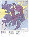
Geological map of Guallatiri
