
Lake Titicaca facts for kids
Quick facts for kids Lake Titicaca |
|
|---|---|

View of the lake from the lake's Isla del Sol
|
|
| Coordinates | 15°45′S 69°25′W / 15.750°S 69.417°W |
| Type | Mountain lake |
| Primary inflows | 27 rivers |
| Primary outflows | Desaguadero River Evaporation |
| Catchment area | 58,000 km2 (22,400 sq mi) |
| Basin countries | Bolivia Peru |
| Max. length | 190 km (118 mi) |
| Max. width | 80 km (50 mi) |
| Surface area | 8,372 km2 (3,232 sq mi) |
| Average depth | 107 m (351 ft) |
| Max. depth | 281 m (922 ft) |
| Water volume | 893 km3 (214 cu mi) |
| Residence time | 1343 years |
| Shore length1 | 1,125 km (699 mi) |
| Surface elevation | 3,812 m (12,507 ft) |
| Frozen | never |
| Islands | 42+ (see article) |
| Sections/sub-basins | Wiñaymarka |
| Settlements | Copacabana, Bolivia Puno, Peru |
| Designated: | 26 August 1998 |
| 1 Shore length is not a well-defined measure. | |
Lake Titicaca is a very large and deep lake high up in the Andes mountains. Part of the lake is in Bolivia, and the other part is in Peru. It is the biggest lake in all of South America.
Lake Titicaca is located 3,812 m (12,507 ft) above sea level. It is often called the "highest navigable lake" in the world. This means it is the highest lake where large boats can travel for trade. There are many other lakes that are higher, but they are not used by big boats. The lake has more than 40 islands. Many of these islands are home to people.
Contents
Amazing Animals and Plants
Lake Titicaca is home to over 530 different kinds of water animals. Some animals that live only in or near the lake are in danger of disappearing. These include the huge Titicaca water frog and the Titicaca grebe. The Titicaca grebe is a special bird that cannot fly.
Since the year 2000, the water level of Lake Titicaca has been getting lower. This is because there are shorter rainy seasons. Also, the glaciers that feed the lake are melting. The Global Nature Fund (GNF) says that pollution and new animals introduced by humans are threatening the natural life in the lake.

Islands of Lake Titicaca
Lake Titicaca has many islands. Some of them are famous for their unique cultures and history.
The Uros Floating Islands

The "Floating Islands" are special islands made by the Uros people. They build these islands using many layers of cut totora reeds. These are thick reeds that grow in Lake Titicaca. The Uros keep building up the islands by adding more reeds.
A long time ago, the Uru people came from the Amazon river area. They moved to Lake Titicaca. The people already living there did not let them have their own land. So, the Uros built these reed islands. They could move the islands into deeper water or to different parts of the lake to stay safe.
The islands have a golden color. Many are about 15 by 15 m (50 by 50 ft) in size. The biggest ones are about half the size of a football field. Each island has a few houses. The people living on an island are usually all related to each other. Some islands even have watchtowers and other buildings, all made from reeds.
Today, about 1,200 Uros live on 60 islands. Most of these islands are near Puno, a large port town in Peru. The islands have become a popular place for tourists to visit. This helps the Uros earn money. They take visitors to the islands by motorboat and sell handmade crafts.
Amantani Island

Amantani is another small island on Lake Titicaca. The people who live here speak the Quechua language. Around 4,000 people live in 10 villages on this nearly round island. It is about 15 km2 (6 sq mi) big.
Amantani has two mountain peaks. They are called Pachatata (Father Earth) and Pachamama (Mother Earth). Both peaks have very old ruins at the top. The hillsides are used to grow wheat, potatoes, and other vegetables. Most of the small fields are worked by hand. Long stone fences divide the fields. Cattle and sheep also eat grass on the hillsides.
Taquile Island

Taquile is a hilly island about 45 km (28 mi) east of Puno. About 2,200 people live here. The island is long and narrow. It was used as a prison during the time of the Spanish Colony and up until the 1900s. In 1970, the island became the property of the Taquile people. They have lived on the island ever since. There are ruins from before the Inca time on the highest part of the island.
Taquile is very famous for its weaving and knitting. Their special textile art was honored by UNESCO. It was called a "Masterpiece of the Oral and Intangible Heritage of Humanity."
Isla del Sol (Island of the Sun)
Isla del Sol means "island of the sun" in Spanish. It is one of the biggest islands in the lake. It is a rocky and hilly island. There are no cars or paved roads on the island. About 800 families live here.
There are over 180 ancient ruins on the island. Most of these ruins are from the Inca period, around the 15th century AD. Some of the ruins on the island include the Sacred Rock, a maze-like building called Chicana, Kasa Pata, and Pilco Kaima. The island is also mentioned in old Inca stories and myths.
Isla de la Luna (Island of the Moon)

Isla de la Luna means "island of the moon" in Spanish. It is located east of the larger Isla del Sol. Legends say that this is where the god Viracocha told the moon to rise.
Archaeological digs show that the Tiwanaku people built a large temple on the Island of the Moon. This was between 650 and 1000 AD. The buildings you see on the island today were built by the Inca people on top of the older Tiwanaku structures.
Suriki Island
Suriki Island is in the Bolivian part of Lake Titicaca. Suriki is the last place where people still make traditional reed boats.
Images for kids
-
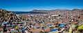
A view of Lake Titicaca taken from the city of Puno
-
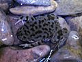
Two types of Telmatobius frogs live in the lake. The smaller marbled water frog (pictured, at Isla del Sol) and the larger Titicaca water frog.
-
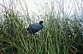
An Andean coot among totora reeds
-
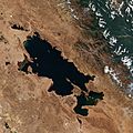
View from the Sentinel-2 satellite in 2020
-
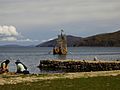
A raft made of totora reeds on Lake Titicaca near the Isla del Sol (Bolivia)
-
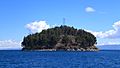
Chelleca island on the Bolivian side
-
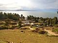
Amantani Island – Peru: In the background is the Capachica Peninsula
-
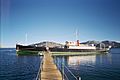
The SS Yavari ship in Puno, 2002

.jpg)


.JPG)

See also
 In Spanish: Titicaca para niños
