
Isla del Sol facts for kids

Isla del Sol means Island of the Sun. It is a special island located in the southern part of Lake Titicaca. This lake is very high up in the Andes Mountains. The island belongs to Bolivia, specifically to the La Paz Department.
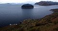
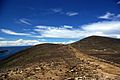
The island is rocky and hilly, with many eucalyptus trees. You won't find any cars or paved roads here! About 800 families live on the island. They mostly earn a living by farming, fishing, and welcoming tourists. The biggest villages are Yumani and Challapampa.
Isla del Sol has more than 80 ancient ruins. Most of these ruins are from the Inca period, around the 1400s AD. However, archaeologists have found signs that people lived on the island much, much earlier, possibly as far back as 3000 BC! Many hills on the island have special farm terraces. These terraces helped ancient people grow crops on the steep, rocky land. Some famous ruins include Titi Qala, a maze-like building called Chinkana, Q'asa Pata, and Pillkukayna. The Incas believed their sun god was born on this island.
Contents
What's in a Name?

The Aymara name for the island is Titi'kaka. No one is completely sure what this word originally meant. Some experts think it comes from titi (which means Andean mountain cat, or lead-colored) and qala (which means rock).
An old dictionary from 1612, written by Ludovico Bertonio, lists the phrase Tahksi kala as "foundation stone." This might hint at the Inca story that the Sun and Moon were born in the lake.
Island History

A writer named Bernabé Cobo wrote down two different stories about how the Inca people began. Both stories happened on the northern part of Isla del Sol. The first Inca ruler, Manco Cápac, was said to have appeared from a large rock called Titi Qala. Manco Cápac was believed to be the son of Inti, the sun god.
In one story, people were scared because the sky was dark for many days. Then, they saw the Sun come out from the rock and believed it was the Sun's home. In another story, people thought the rock was special because the Sun hid under it during a huge flood. Isla del Sol was the first land to appear after the floodwaters went down, and the Sun came out from Titi Qala to light up the sky again.
A temple was built at this rock. Later, the 10th Inca ruler, Tupac Inca Yupanqui, made it even bigger. He also built a place for special women (mamaconas) and an inn (tambo) for visitors.
Archaeological Discoveries

Archaeologists have found many interesting things on Isla del Sol. At a site called Ch'uxu Qullu, they found very old remains from around 2200 BC. They found eight pieces of obsidian, a type of volcanic glass. These pieces came from a place called Chivay, far away in the Colca Canyon. This shows that people on the island traded with others over long distances, even thousands of years ago!
Obsidian from Chivay has also been found at another nearby site in Peru called Jisk'a Iru Muqu. This suggests that the cultures in these two places were connected a long time ago.
Lake Levels Over Time
Studies of the lake bottom show that Lake Titicaca is very deep around Isla del Sol. About 3100 BC, the lake level was much lower than it is today. But by 2000 BC, it was almost at its current level. This means that even in 2200 BC, the island was separated from the mainland by water. The discoveries at Ch'uxuqullu tell us that people living by the lake back then had good boats to travel to the island.
Who Lived Here?
People have lived on Isla del Sol continuously from at least 2200 BC until today. There were important settlements during different periods:
- Early Formative (1800-1100 BC)
- Middle Formative (1100-500 BC)
- Upper Formative (500 BC - AD 500)
The oldest pottery found on the island dates back to between 1426 and 1316 BC.
A very important Tiwanaku settlement was also on the island. The site of Chucaripupata was a major Tiwanaku religious place, located above the Titi Qala rock that the Incas later made famous. All these ancient sites are on the western side of the island.

Chucaripupata is very close to Titi Qala. Just above them is another rock called Murokata. It's possible that Murokata was the "sacred rock" for the Tiwanaku culture.
Archaeological findings show that neither Murokata nor Titi Qala were used much between 1000 AD and 1450 AD. But when the Incas took over the southern Lake Titicaca region, the Titi Qala area became one of the most important pilgrimage sites in the Inca empire. It was as important as the famous oracle at Pachacamac near Lima.
From 1989 to 1992, archaeologists explored underwater near Isla del Sol. They found artifacts from both the Inca and Tiwanaku cultures. These items are now shown in a museum in Challapampa. Today, tourism brings most of the money to the island, but people still farm and fish to support themselves.
Climate
| Climate data for Isla de Sol (located in Yumani), elevation: 3,976 metres (13,045 ft), 1981–2010 normals, extremes 1978–present | |||||||||||||
|---|---|---|---|---|---|---|---|---|---|---|---|---|---|
| Month | Jan | Feb | Mar | Apr | May | Jun | Jul | Aug | Sep | Oct | Nov | Dec | Year |
| Record high °C (°F) | 21.0 (69.8) |
21.0 (69.8) |
20.0 (68.0) |
21.0 (69.8) |
20.0 (68.0) |
19.8 (67.6) |
19.2 (66.6) |
20.4 (68.7) |
20.9 (69.6) |
23.0 (73.4) |
24.6 (76.3) |
21.0 (69.8) |
23.5 (74.3) |
| Mean daily maximum °C (°F) | 14.4 (57.9) |
14.4 (57.9) |
14.6 (58.3) |
14.4 (57.9) |
14.3 (57.7) |
13.7 (56.7) |
13.4 (56.1) |
13.9 (57.0) |
14.5 (58.1) |
15.0 (59.0) |
15.2 (59.4) |
15.1 (59.2) |
14.3 (57.7) |
| Daily mean °C (°F) | 9.4 (48.9) |
9.5 (49.1) |
9.5 (49.1) |
9.4 (48.9) |
9.0 (48.2) |
8.2 (46.8) |
7.9 (46.2) |
8.4 (47.1) |
9.0 (48.2) |
9.6 (49.3) |
9.7 (49.5) |
9.8 (49.6) |
9.1 (48.4) |
| Mean daily minimum °C (°F) | 4.4 (39.9) |
4.5 (40.1) |
4.5 (40.1) |
4.4 (39.9) |
3.6 (38.5) |
2.7 (36.9) |
2.5 (36.5) |
3.0 (37.4) |
3.5 (38.3) |
4.1 (39.4) |
4.4 (39.9) |
4.5 (40.1) |
3.9 (39.0) |
| Record low °C (°F) | −4.0 (24.8) |
−2.0 (28.4) |
−2.3 (27.9) |
−3.0 (26.6) |
−4.0 (24.8) |
−3.0 (26.6) |
−4.5 (23.9) |
−6.0 (21.2) |
−2.0 (28.4) |
−2.0 (28.4) |
−2.4 (27.7) |
−2.0 (28.4) |
−4.5 (23.9) |
| Average precipitation mm (inches) | 164.1 (6.46) |
117.4 (4.62) |
97.1 (3.82) |
44.5 (1.75) |
11.5 (0.45) |
11.2 (0.44) |
5.5 (0.22) |
24.0 (0.94) |
28.4 (1.12) |
38.2 (1.50) |
51.7 (2.04) |
96.6 (3.80) |
641.2 (25.24) |
| Average precipitation days | 15.9 | 13.6 | 11.5 | 6.4 | 2.7 | 2.9 | 1.6 | 3.8 | 4.9 | 6.7 | 7.6 | 12.2 | 87.1 |
| Average snowy days | 0.0 | 0.0 | 0.0 | 0.0 | 0.0 | 0.0 | 0.04 | 0.08 | 0.0 | 0.0 | 0.0 | 0.0 | 0.15 |
| Mean monthly sunshine hours | 167.5 | 154.7 | 170.0 | 190.6 | 238.8 | 190.2 | 219.7 | 266.4 | 219.1 | 229.5 | 236.8 | 190.8 | 2,474.1 |
| Mean daily sunshine hours | 6.9 | 6.3 | 6.9 | 7.5 | 8.4 | 7.0 | 8.6 | 9.0 | 8.5 | 8.0 | 9.0 | 6.8 | 7.7 |
| Source: Servicio Nacional de Meteorología e Hidrología de Bolivia | |||||||||||||
Images for kids
-
The ruins of Pillkukayna, at the southern end of the island.
-
Walking path down the centre of the island.
-
Adobe bricks drying in the sun.


See also
 In Spanish: Isla del Sol para niños
