Jisk'a Iru Muqu facts for kids

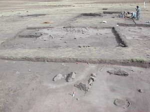
Excavations at the site of Jisk'a Iru Muqu in 2002
|
|
| Alternative name | Jiskairumoko |
|---|---|
| Location | Puno Region, Peru |
| Region | Ilave Valley, Lake Titicaca Basin |
| Coordinates | 16°12′40″S 69°45′50″W / 16.21111°S 69.76389°W |
| Altitude | 3,890 m (12,762 ft) |
| Type | open-air village site |
| Area | 0.4 ha (0.99 acres) |
| History | |
| Founded | Approximately 3,400 BC |
| Abandoned | Approximately 1,600 BC |
| Periods | Late Archaic to Early Formative |
| Cultures | South-Central Highland |
Jisk'a Iru Muqu (pronounced "His-ka Ee-roo Moo-koo") is an amazing ancient place in Peru. Its name comes from the Aymara people's language. It means "small iru grass knot." This site is about 54 kilometers (34 miles) south-east of Puno, a city in Peru.
This ancient village sits high up in the mountains. It is about 4,115 meters (13,500 feet) above sea level! It is located in the Aymara community of Jachacachi. The site is also very close to the Ilave River, which flows into Lake Titicaca. People lived at Jisk'a Iru Muqu for a very long time. They were there from the late Archaic period until the early Formative period.
Contents
Discovering Jisk'a Iru Muqu
Archaeologists are like history detectives. They study old things to learn about people who lived long ago. Jisk'a Iru Muqu is an important place for them.
First Discoveries
An archaeologist named Mark Aldenderfer first officially recorded the site in 1994. He was doing a "pedestrian survey." This means he walked around the Ilave River area, looking for signs of ancient life.
Starting the Dig
The first real digging, called an "excavation," happened in 1995. Jisk'a Iru Muqu was the very first open-air Archaic site found and dug up in the Lake Titicaca Basin. This made it a very special discovery!
More Digging and New Tools
From 1999 to 2004, more excavations took place. A team from the University of California, Santa Barbara led by Mark Aldenderfer worked there. Other team members included Nathan Craig and Nicholas Tripcevich. They dug during the winter months in Peru.
The team used special computer tools called GIS methods. These tools helped them record everything they found. They could map out the exposed surfaces of the site very carefully. This helped them understand how the ancient village was laid out.
Changes to the Site
Sadly, in 2005, a tractor plowed over the site. This can damage ancient remains. Archaeologists work hard to protect these important places.
See also
 In Spanish: Jiskairumoko para niños
 | Kyle Baker |
 | Joseph Yoakum |
 | Laura Wheeler Waring |
 | Henry Ossawa Tanner |


