
Andes facts for kids
Quick facts for kids Andes Mountains |
|
|---|---|
| Spanish: Cordillera de los Andes | |

An aerial view of the Andes between Santiago in Chile and Mendoza, Argentina with a large ice field on the southern slope of San José volcano (left), Marmolejo (right), and Tupungato (far right)
|
|
| Highest point | |
| Peak | Aconcagua (Mendoza, Argentina) |
| Elevation | 6,961 m (22,838 ft) |
| Dimensions | |
| Length | 8,900 km (5,500 mi) |
| Width | 330 km (210 mi) |
| Geography | |

Map of South America showing the Andes running along the entire western part (roughly parallel to the Pacific coast) of the continent
|
|
| Country | |
| Range coordinates | 32°S 70°W / 32°S 70°W |
.jpg)

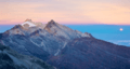
The Andes Mountains (also called the Andes or Andean Mountain Range) are the longest mountain range on land in the world. They stretch along the entire western side of South America. This amazing mountain chain is about 8,900 kilometers (5,500 miles) long. It is usually between 200 and 700 kilometers (120-430 miles) wide. The Andes reach an average height of about 4,000 meters (13,000 feet). These mountains pass through seven countries: Argentina, Chile, Bolivia, Peru, Ecuador, Colombia, and Venezuela.
The Andes are made up of many smaller mountain ranges. These are separated by lower areas. You can find several high, flat areas called plateaus here. Important cities like Bogotá and La Paz are built on some of these plateaus. The Altiplano Plateau is the second highest in the world, after the Tibetan Plateau. The Andes are also divided into three main climate zones: the Tropical Andes, the Dry Andes, and the Wet Andes.
Outside of Asia, the Andes are the highest mountains. The tallest peak is Aconcagua in Argentina, reaching about 6,961 meters (22,838 feet) high. Did you know that the top of Chimborazo in Ecuador is the farthest point from the Earth's center? This is because the Earth bulges out a bit at the equator. The Andes also have the world's highest volcanoes. One example is Ojos del Salado, which is 6,893 meters (22,615 feet) tall. It sits on the border between Chile and Argentina.
The Andes are part of an even bigger system called the American Cordillera. This is a long chain of mountains that forms the western "backbone" of both North and South America, and even Antarctica.
Contents
What's in a Name?
The name Andes might come from the Quechua word anti, which means "east." This is like Antisuyu, the "east region" of the Inca Empire. Some people think it comes from the older Aymara language word anta, meaning "copper."
The word cordillera comes from the Spanish word cordel, meaning "rope." It describes a long, continuous chain of mountains, like the Andes.
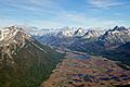
Where are the Andes Located?
%E2%80%93Valle_Carbajal_01.jpg)
The Andes Mountains can be divided into three main parts:
- The Southern Andes are in Argentina and Chile. They are south of the Llullaillaco volcano.
- The Central Andes are found in Bolivia and Peru.
- The Northern Andes are in Colombia, Ecuador, and Venezuela. This part of the Andes splits into three branches.
Sometimes, the Sierra Nevada de Santa Marta mountains in Colombia are also considered part of the Northern Andes.
How the Andes Mountains Formed
The Andes are part of the Pacific Ring of Fire. This is an area around the Pacific Ocean where many volcanoes and earthquakes happen. The Andes formed because huge pieces of the Earth's crust, called tectonic plates, crashed into each other. Over millions of years, the Nazca Plate and the Antarctic Plate slid underneath the South American Plate. This process, called subduction, pushed the land upwards. It created the towering mountains we see today.
The rise of the Andes also affected the weather. It created a "rain shadow" on the western side, leading to very dry areas like the Atacama Desert. This dryness actually helped the mountains grow even taller. The Andes are bordered by large flat areas to the east, like the Amazon Basin. To the west, they meet the Pacific Ocean. These mountains also hold a lot of iron ore.
Earthquakes and Volcanoes
The movement of these giant plates still causes many earthquakes and volcanic eruptions. This happens along the entire western coast of South America. Some of the strongest earthquakes ever recorded have happened here. For example, the 1960 Valdivia earthquake was the most powerful one measured.
The number and strength of earthquakes change along the mountain range. This depends on how the plates rub against each other. Some areas have many small earthquakes. Other areas might have fewer, but much stronger, earthquakes.


The Andes have many active volcanoes. These are grouped into four main areas. The volcanoes are a direct result of the Earth's plates pushing together. This creates hot melted rock, called magma, that rises to the surface. Each volcano can be different in how it erupts and what it produces.
Valuable Resources in the Andes
The Andes Mountains are rich in valuable natural resources. They have huge deposits of ores and salt. Countries like Chile and Peru are the world's top exporters of copper. This copper formed from hot liquids deep inside the Earth. The dry climate in some parts of the Andes helped preserve these deposits.
You can also find large salt flats, called "salars," in the Andes. The Salar de Atacama is the biggest source of lithium in the world. The Salar de Uyuni holds the largest reserves of this element. Historically, areas like Cerro Rico de Potosí in Bolivia were famous for their huge silver deposits. Today, Bolivia mainly produces tin.
Climate and the Mountains
The climate in the Andes is closely linked to the weather in South America. For example, the very dry Atacama Desert next to the mountains is a result of the Andes' formation. The mountains block moisture, creating a "rain shadow." This lack of rain also affected how the mountains grew over time. It helped them spread out more to the east.
A Look at Andean History
Long ago, the Andes Mountains were home to hunter-gatherers. Over time, people learned to farm and built amazing civilizations. The most famous was the Inca Empire in the 15th century. The Incas were powerful and built impressive things like aqueducts and roads. Some of these structures are still standing today.
In the 16th century, Spanish explorers arrived. They faced challenges like diseases and internal conflicts within the Inca Empire. A small group of Spaniards, led by Francisco Pizarro, along with thousands of allies from nations the Incas had conquered, defeated the Incas in 1532. One famous Inca city the Spanish never found was Machu Picchu. It remained hidden high in the mountains. Today, the main languages spoken by Andean peoples are Quechua and Aymara language.
Later, in the 19th century, the Andes became a battleground. People fought a series of independence wars to break free from Spanish rule. Many former Spanish lands became independent Andean countries.
Weather and Water in the Andes


The weather in the Andes changes a lot. It depends on how far north or south you are, how high up you go, and how close you are to the ocean. As you go higher, the temperature, air pressure, and humidity all drop. The southern Andes are cool and rainy. The central part is very dry. The northern Andes are usually warm and rainy, with an average temperature of 18°C (64°F) in Colombia.
The weather can change quickly over short distances. You might find rainforests just a few kilometers from snow-covered peaks like Cotopaxi. The mountains greatly affect the temperatures of nearby areas. The line where snow stays all year round, called the snow line, also changes. It's very high in the tropical Andes (around 4,500-4,800 meters or 14,800-15,700 feet). It gets lower as you go further south, reaching only 300 meters (980 feet) in Tierra del Fuego.
.jpg)
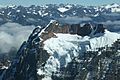
In the dry central Andes of Chile and Argentina, you'll see more rock glaciers than ice glaciers. This is because of the strong sunlight. Even in the highest mountains, which are nearly 7,000 meters (23,000 feet) tall, conditions can be semi-arid. This means they are quite dry.
Plants of the Andes

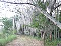
The Andes Mountains stretch across many different natural areas. This means they have a huge variety of plants. You can find everything from Caribbean-like areas in Venezuela to cold, wet places near Cape Horn. Sadly, many rainforests and dry forests that once covered the northern Andes have been cut down.
About 30,000 different kinds of vascular plants grow in the Andes. Roughly half of these plants are found nowhere else in the world! This makes the Andes a very special place for plant life. One important plant is the Cinchona pubescens tree. It's a source of quinine, which is used to treat malaria. Other important crops that first grew in the Andes include tobacco and potatoes.
High up in the Andes, you can find Polylepis forests. These trees grow at altitudes of up to 4,500 meters (14,800 feet) above sea level. It's not clear if these forests were always spread out in patches, or if people started clearing them long ago. Today, these trees are highly endangered. Some believe only 10% of the original forests remain.
Animals of the Andes

.jpg)
The Andes are home to an incredible variety of animals. They are the most important region in the world for amphibians, with almost 1,000 species. About two-thirds of these amphibians are found only here. The Andes also have nearly 600 species of mammals, over 1,700 species of birds, more than 600 species of reptiles, and almost 400 species of fish. Many of these animals are unique to the Andes.
You can see vicuñas and guanacos living on the Altiplano. Their relatives, the llama and alpaca, are raised by local people. They are used as pack animals and for their meat and wool. The chinchilla, a small rodent, lives in the high mountain areas. The Andean condor, the largest flying bird in the Western Hemisphere, soars over much of the Andes.
Lake Titicaca is home to several unique animals. These include the highly endangered Titicaca flightless grebe and the Titicaca water frog. Many different kinds of hummingbirds live in the Andes, especially in the humid "cloud forests" at lower altitudes. These forests are rich in plants and animals. You might spot the threatened mountain tapir, spectacled bear, and yellow-tailed woolly monkey there.
People and Life in the Andes
The Andes Mountains have shaped cultures for thousands of years. The Inca civilization grew very strong in the central Andes during the 15th century. They managed their empire carefully, building amazing aqueducts and roads. Some of these ancient structures are still used today.

After the Spanish arrived, the Incas faced difficult times. In 1532, a small Spanish army, with the help of many local allies, defeated the Incas. One of the few Inca sites the Spanish never found was Machu Picchu. It remained hidden high on a mountain peak. The main languages still spoken by Andean peoples are Quechua and Aymara language.
Major Cities in the Andes
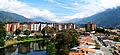
Today, some of the largest cities in the Andes include Bogotá (with over ten million people), Santiago, Medellín, Cali, and Quito. Lima is a large coastal city near the Andes and is the biggest city in all Andean countries.
La Paz, Bolivia's seat of government, is the highest capital city in the world. It sits at about 3,650 meters (11,980 feet) high. Parts of La Paz, like El Alto, go up to 4,200 meters (13,800 feet).
Other important cities in or near the Andes include Mendoza in Argentina, Cochabamba in Bolivia, Arequipa in Peru, Cuenca in Ecuador, and Mérida in Venezuela.
- Major cities in the Andes
-
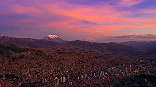
La Paz, Bolivia, the world's highest capital city.
-
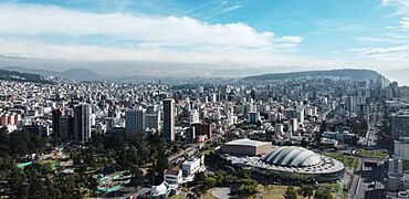
Quito, Ecuador
-
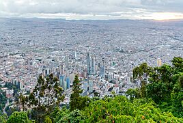
Bogotá, Colombia
-
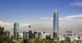
Santiago, Chile


.jpeg)
Getting Around the Mountains
Main cities and large towns are connected by paved roads. Smaller towns often have dirt roads, which might need a four-wheel-drive vehicle. Building highways and railroads across the Andes has always been very difficult and expensive because of the rough terrain. Many people travel by aircraft.
There is one railroad that connects Chile with Peru through the Andes. Other railroads connect Chile through southern Bolivia. Bolivia also has several highways that cross the Andes. Some of these were built during a war with Paraguay to move troops and supplies.
For many decades, Chile claimed land on the eastern side of the Andes. These claims were given up around 1870 during a conflict between Chile, Bolivia, and Peru. As a result, Bolivia lost its access to the Pacific Coast and has been landlocked ever since.
In some high mountain areas, villages are still quite remote. Travel by motorized vehicles is difficult. Here, relatives of the camel, like the llama and alpaca, are still important pack animals. Donkeys, mules, and horses are also very helpful.
Farming in the Andes

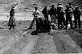
Ancient peoples in the Andes, like the Incas, used irrigation for over 6,000 years. Because of the steep mountain slopes, they built terraces to create flat areas for farming. This was especially important for the Inca Empire to feed its growing population.
The potato is a very important food crop in the Andes. Maize (corn) was also crucial and used to make chicha, a traditional drink. Today, tobacco, cotton, quinoa, and coffee are major crops grown for export. Coca is also grown for legal local use in a mildly stimulating herbal tea.

In areas without irrigation, most land is used for grazing animals. During the rainy summer, some grazing land is used to grow crops like potatoes, barley, and wheat. Irrigation helps farmers plant crops earlier, which provides food when it's scarce. It also allows them to grow crops like onions and carrots in the dry winter.
Mining for Riches

The Andes became famous for their rich minerals when the Spanish arrived in South America. While Andean peoples already made jewelry from gold, large-scale mining began with the Spanish. Potosí in Bolivia and Cerro de Pasco in Peru were major mines for the Spanish Empire. The names Río de la Plata and Argentina even come from the silver found in Potosí.
Today, mining in the Andes of Chile and Peru makes these countries the top producers of copper in the world. Peru also has the fourth-largest goldmine globally, called Yanacocha. The Bolivian Andes mainly produce tin, though silver mining was very important in the past. The Andes also have a huge supply of lithium. Argentina, Bolivia, and Chile hold the three largest reserves of lithium in the world.
Mining in the cold, high Andes can be challenging for workers and machinery. There are also concerns about how mining affects glaciers and the environment.
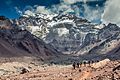
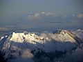
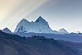
Tallest Peaks of the Andes
Here are some of the major peaks in the Andes Mountains. The highest of them all is Aconcagua in Argentina.
Argentina
.jpg)
- Aconcagua, 6,961 meters (22,838 feet)
- Cerro Bonete, 6,759 meters (22,175 feet)
- Galán, 5,912 meters (19,396 feet)
- Mercedario, 6,720 meters (22,047 feet)
- Pissis, 6,795 meters (22,293 feet)
On the Border of Argentina and Chile
.jpg)
- Cerro Bayo, 5,401 meters (17,720 feet)
- Cerro Fitz Roy, 3,375 meters (11,073 feet) or 3,405 meters (11,171 feet), Patagonia, also known as Cerro Chaltén
- Cerro Escorial, 5,447 meters (17,871 feet)
- Cordón del Azufre, 5,463 meters (17,923 feet)
- Falso Azufre, 5,890 meters (19,324 feet)
- Incahuasi, 6,620 meters (21,719 feet)
- Lastarria, 5,697 meters (18,691 feet)
- Llullaillaco, 6,739 meters (22,110 feet)
- Maipo, 5,264 meters (17,270 feet)
- Marmolejo, 6,110 meters (20,046 feet)
- Ojos del Salado, 6,893 meters (22,615 feet)
- Olca, 5,407 meters (17,740 feet)
- Sierra Nevada de Lagunas Bravas, 6,127 meters (20,000 feet)
- Socompa, 6,051 meters (19,852 feet)
- Nevado Tres Cruces, 6,749 meters (22,142 feet) (south summit)
- Tronador, 3,491 meters (11,453 feet)
- Tupungato, 6,570 meters (21,555 feet)
- Nacimiento, 6,492 meters (21,299 feet)
Bolivia


- Janq'u Uma, 6,427 meters (21,086 feet)
- Cabaraya, 5,860 meters (19,226 feet)
- Cerro Cañapa, 5,882 meters (19,298 feet)
- Cerro Lípez, 5,929 meters (19,452 feet)
- Cerro Nelly, 5,676 meters (18,622 feet)
- Chacaltaya, 5,422 meters (17,789 feet)
- Chachacomani, 6,074 meters (19,928 feet)
- Chaupi Orco, 6,044 meters (19,829 feet)
- Chearoco, 6,127 meters (20,000 feet)
- Huayna Potosí, 6,088 meters (19,974 feet)
- Illampu, 6,368 meters (20,892 feet)
- Illimani, 6,438 meters (21,122 feet)
- Kunturiri, 5,648 meters (18,530 feet)
- Layqa Qullu, 6,166 meters (20,230 feet)
- Laram Q'awa, 5,182 meters (17,001 feet)
- Macizo de Pacuni, 5,400 meters (17,700 feet)
- Mururata, 5,871 meters (19,262 feet)
- Nevado Anallajsi, 5,750 meters (18,860 feet)
- Nevado Charquini, 5,392 meters (17,690 feet)
- Nevado Sajama, 6,542 meters (21,463 feet)
- Patilla Pata, 5,300 meters (17,400 feet)
- Pico del Norte, 6,070 meters (19,910 feet)
- Tata Sabaya, 5,430 meters (17,810 feet)
- Tunari, 5,035 meters (16,519 feet)
- Uturuncu, 6,008 meters (19,711 feet)
- Wayna Potosí, 4,969 meters (16,302 feet)
On the Border of Bolivia and Chile

- Acotango, 6,052 meters (19,856 feet)
- Aucanquilcha, 6,176 meters (20,262 feet)
- Michincha, 5,305 meters (17,405 feet)
- Iru Phutunqu, 5,163 meters (16,939 feet)
- Licancabur, 5,920 meters (19,423 feet)
- Olca, 5,407 meters (17,740 feet)
- Parinacota, 6,348 meters (20,827 feet)
- Paruma, 5,420 meters (17,780 feet)
- Pomerape, 6,282 meters (20,610 feet)
Chile

- Monte San Valentin, 4,058 meters (13,314 feet)
- Cerro Paine Grande, 2,884 meters (9,462 feet)
- Cerro Macá, c.2,300 meters (7,500 feet)
- Monte Darwin, c.2,500 meters (8,200 feet)
- Volcan Hudson, c.1,900 meters (6,200 feet)
- Cerro Castillo Dynevor, c.1,100 meters (3,600 feet)
- Mount Tarn, c.825 meters (2,707 feet)
- Polleras, c.5,993 meters (19,662 feet)
- Acamarachi, c.6,046 meters (19,836 feet)
Colombia
.jpg)
- Nevado del Huila, 5,365 meters (17,602 feet)
- Nevado del Ruiz, 5,321 meters (17,457 feet)
- Nevado del Tolima, 5,205 meters (17,077 feet)
- Pico Pan de Azúcar, 5,200 meters (17,100 feet)
- Ritacuba Negro, 5,320 meters (17,450 feet)
- Nevado del Cumbal, 4,764 meters (15,630 feet)
- Cerro Negro de Mayasquer, 4,445 meters (14,583 feet)
- Ritacuba Blanco, 5,410 meters (17,750 feet)
- Nevado del Quindío, 5,215 meters (17,110 feet)
- Puracé, 4,655 meters (15,272 feet)
- Santa Isabel, 4,955 meters (16,257 feet)
- Doña Juana, 4,150 meters (13,620 feet)
- Galeras, 4,276 meters (14,029 feet)
- Azufral, 4,070 meters (13,350 feet)
Ecuador

- Antisana, 5,752 meters (18,871 feet)
- Cayambe, 5,790 meters (18,996 feet)
- Chiles, 4,723 meters (15,495 feet)
- Chimborazo, 6,268 meters (20,564 feet)
- Corazón, 4,790 meters (15,715 feet)
- Cotopaxi, 5,897 meters (19,347 feet)
- El Altar, 5,320 meters (17,454 feet)
- Illiniza, 5,248 meters (17,218 feet)
- Pichincha, 4,784 meters (15,696 feet)
- Quilotoa, 3,914 meters (12,841 feet)
- Reventador, 3,562 meters (11,686 feet)
- Sangay, 5,230 meters (17,160 feet)
- Tungurahua, 5,023 meters (16,480 feet)
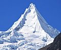
Peru


- Alpamayo, 5,947 meters (19,511 feet)
- Artesonraju, 6,025 meters (19,767 feet)
- Carnicero, 5,960 meters (19,550 feet)
- Chumpe, 6,106 meters (20,033 feet)
- Coropuna, 6,377 meters (20,922 feet)
- El Misti, 5,822 meters (19,098 feet)
- El Toro, 5,830 meters (19,130 feet)
- Huandoy, 6,395 meters (20,981 feet)
- Huascarán, 6,768 meters (22,205 feet)
- Jirishanca, 6,094 meters (19,993 feet)
- Pumasillo, 5,991 meters (19,656 feet)
- Rasac, 6,040 meters (19,820 feet)
- Rondoy, 5,870 meters (19,260 feet)
- Sarapo, 6,127 meters (20,000 feet)
- Salcantay, 6,271 meters (20,574 feet)
- Seria Norte, 5,860 meters (19,230 feet)
- Siula Grande, 6,344 meters (20,814 feet)
- Huaytapallana, 5,557 meters (18,232 feet)
- Yerupaja, 6,635 meters (21,768 feet)
- Yerupaja Chico, 6,089 meters (19,977 feet)
Venezuela

- Pico Bolívar, 4,978 meters (16,332 feet)
- Pico Humboldt, 4,940 meters (16,210 feet)
- Pico Bonpland, 4,880 meters (16,010 feet)
- Pico La Concha, 4,920 meters (16,140 feet)
- Pico Piedras Blancas, 4,740 meters (15,550 feet)
- Pico El Águila, 4,180 meters (13,710 feet)
- Pico El Toro 4,729 meters (15,515 feet)
- Pico El León 4,740 meters (15,550 feet)
- Pico Mucuñuque 4,609 meters (15,121 feet)
Images for kids
-
Aconcagua
-
Aerial view of Valle Carbajal in the Fuegian Andes
-
Rift valley near Quilotoa, Ecuador
-
Bolivian Andes
-
Laguna de Sonso tropical dry forest in Northern Andes
-
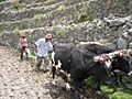
Peruvian farmers sowing maize and beans
-
Irrigating land in the Peruvian Andes
-
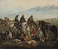
Chilean huasos, 19th century
-
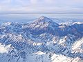
The Aconcagua, Argentina, the highest mountain in the Americas
-
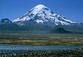
Sajama, Bolivia
-
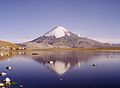
Parinacota, Bolivia/Chile
-
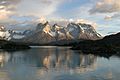
View of Cuernos del Paine in Torres del Paine National Park, Chile
-
Nevado del Huila, Colombia
-
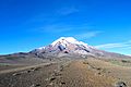
Chimborazo near Riobamba, Ecuador
-
Huandoy, Peru
-
Alpamayo, Peru
-
Mount Humboldt at sunset
-
View of Mérida, Venezuela


See also
 In Spanish: Cordillera de los Andes para niños
- List of mountains in the Andes
- Andesite line
- Apu (god)
- List of mountain ranges
- Sutter Buttes
