
Nevado del Ruiz facts for kids
Quick facts for kids Nevado del Ruiz |
|
|---|---|

Steam on the mountain in July 2007
|
|
| Highest point | |
| Elevation | 5,321 metres (17,457 ft) |
| Geography | |
| Location | Colombia |
| Parent range | Cordillera Central |
| Geology | |
| Mountain type | Stratovolcano |
| Volcanic arc/belt | Andean Volcanic Belt |
| Last eruption | 2007 |
| Climbing | |
| First ascent | 1936 by M. Rapp and party |
Nevado del Ruiz, also known as Mount Ruiz, is a large volcano in Colombia. It is about 80 miles (129 km) west of Bogotá. The volcano is close to the town of Armero. It is the highest active volcano in Colombia.
In 1985, a huge lahar (a dangerous mudflow) happened after an eruption. About 23,000 people died when the lahar covered Armero. This made it the deadliest lahar in history. People living near the volcano call it "the Sleeping Lion." This is because it was dormant (sleeping) for almost 150 years before the 1985 Armero lahar.
Contents
About the Volcano
Nevado del Ruiz is a wide, icy stratovolcano. It covers more than 200 kilometres (124 mi) of land. Over time, it has grown from layers of lava and ash. The top of the volcano has a wide crater called Arenas crater. It is 1 kilometer wide and 240 meters deep.
The volcano's sides have steep slopes from past landslides. When the ice on top melts during eruptions, it creates dangerous lahars. These mudflows have caused a lot of damage, including the very famous and deadly eruption in 1985.
Past Eruptions and Lahars
Nevado del Ruiz has erupted many times before. In 1595, a lahar flowed down two river valleys. It killed 636 people. Then, in 1845, another huge lahar flooded a river valley. This one killed over 1000 people. It traveled for 70 kilometers! Both of these lahars likely formed when snow and ice on the volcano's summit melted.
Signs Before the 1985 Eruption

Nevado del Ruiz showed many signs of activity in the three months before its 1985 eruption. Scientists studied gas from the volcano's vents. They found a mix of carbon dioxide and sulfur dioxide. This meant that magma was releasing gases.
A report on October 22, 1985, warned about a very high risk of lahars. It also suggested simple ways for local towns to prepare. During October, the amount of steam from the volcano increased. The gases were very hot, from 200 to 600 degrees Celsius.
Scientists later realized that certain types of earthquakes happened before the eruption. These are called "long-period earthquakes." They start strong and then slowly fade away. One volcanologist said these earthquakes meant "the volcano was screaming 'I'm about to explode'." But at the time, scientists were not sure what these signs meant.
The 1985 Eruption


On November 13, 1985, at 9:08 pm, Nevado del Ruiz erupted. It shot ash and rock more than 30 kilometers into the sky. The eruption was not huge in terms of magma, but it was very rich in sulfur dioxide gas.
The hot Pyroclastic flows (fast-moving clouds of gas and rock) melted the ice and snow on the summit. This created four thick lahars. These mudflows rushed down several river valleys. They started as water, sand, and gravel. As they moved, they picked up clay and other debris. The lahars were up to 50 meters thick and traveled over 100 kilometers.
The lahars destroyed many homes and towns. The town of Armero was completely buried by mud and debris. About 21,000 people died in Armero, which was three-fourths of its population. The eruption also affected 13 other villages. In total, about 23,000 people died, 5,000 were injured, and over 5,000 homes were destroyed.
This was the second deadliest volcanic disaster in the 20th century. It was also the deadliest lahar ever recorded. The disaster became well-known partly because of a photo of a young girl named Omayra Sánchez. She was trapped for three days before she died. After this event, the USGS Volcano Crisis Assistance Team was created in 1986.
The volcano erupted again in 1988 and 1991.
After the Disaster

The eruption cost Colombia about 7.7 billion dollars. This was about 20% of the country's total economic output for that year. Many people died because there was not enough preparation. Armero had been built right on top of old mudflow paths. Authorities had a map showing the danger, but it was not followed. People were told to stay inside to avoid ash, not realizing that mudflows would bury them.
After the eruption, scientists started watching Nevado del Ruiz very closely. In April 2008, another volcano, Nevado del Huila, erupted. Thousands of people had to leave their homes. Scientists worried it could be another "Nevado del Ruiz."
Survivors of the 1985 disaster moved to other towns. The government helped them find new homes. Armero was not rebuilt. The government declared the site "holy ground" so that no one would suffer there again.
Today, a new system can detect lahars. This gives people more time to get to safety. The system uses Acoustic Flow Monitors (AFM). These devices are placed on the volcano. They listen for ground shaking that could mean a lahar is coming. They warn officials if there is a lot of shaking. These devices were also tested on Mount Rainier in the United States.
Volcano's Location and Features
The glaciers on Nevado del Ruiz formed over hundreds of years. But because of global warming, these glaciers are now melting. Since the 1985 eruption, scientists are worried the glaciers might melt completely.
Nevado del Ruiz is part of the Pacific Ring of Fire. This is an area around the Pacific Ocean where the Earth's crust is unstable. It has many of the world's most active volcanoes. Nevado del Ruiz is the most northern volcano in the Andean Volcanic Belt in South America. This belt formed as one of Earth's plates (the Nazca plate) slides under another (the South American plate). This movement often causes explosive eruptions and pyroclastic flows. These flows can melt snow and ice, creating dangerous lahars.
The volcano is also part of a group of five icy stratovolcanoes called the Ruiz-Tolima volcanic massif.
Images for kids
-
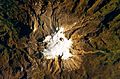
The volcano's summit and upper flanks are covered by several glaciers that appear as a white mass surrounding the Arenas crater.
-
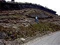
The top of the 11,000 year-old ash fall deposits interstratified with paleosols overlying a channelized debris flow and a sequence of wet surges
-
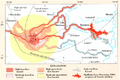
Hazard map for Nevado del Ruiz, with 1985 lahars shown in red
-
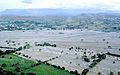
Armero was located in the center of this photograph, taken late November 1985.
-
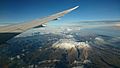
Photo of Nevado del Ruiz taken on approach to El Dorado International Airport, Bogotá. Nevado del Tolima is visible in the background on the left. Approximate altitude of photo: 7,180 m (23,550 ft).


See also
 In Spanish: Nevado del Ruiz para niños
