
Mount Rainier facts for kids
Quick facts for kids Mount Rainier |
|
|---|---|
| Tahoma | |

Mount Rainier's northwestern slope viewed aerially just before sunset on September 6, 2020
|
|
| Highest point | |
| Elevation | 14,411 ft (4,392 m) NAVD 88 |
| Prominence | 13,246 ft (4,037 m) |
| Isolation | 731 mi (1,176 km) |
| Parent peak | Mount Massive, United States of America |
| Listing |
|
| Naming | |
| Etymology | Peter Rainier |
| Geography | |

Mount Rainier
Location in Washington (state)
|
|
| Country | United States |
| State | Washington |
| Parent range | Cascade Range |
| Protected area | Mount Rainier National Park |
| Topo map | USGS Mount Rainier West |
| Geology | |
| Age of rock | 500,000 years |
| Mountain type | Stratovolcano |
| Volcanic arc | Cascade Volcanic Arc |
| Climbing | |
| First ascent | 1870 by Hazard Stevens and P. B. Van Trump |
| Easiest route | rock/ice climb via Disappointment Cleaver |
Mount Rainier (pronounced ray-NEER), also known as Tahoma, is a huge active stratovolcano in the Cascade Range in the Pacific Northwest of the United States. This amazing mountain is found in Mount Rainier National Park. It is about 59 miles (95 km) south of Seattle.
At 14,411 ft (4,392 m) tall, Mount Rainier is the highest mountain in Washington. It is also the most prominent mountain in the contiguous United States. This means it stands out more than any other mountain in the lower 48 states. It is also the tallest in the Cascade Volcanic Arc.
Mount Rainier is one of the most dangerous volcanoes in the world. This is because it could erupt soon and is close to a big city area. It is on the Decade Volcano list. This list includes volcanoes that could cause a lot of damage. Mount Rainier has a lot of glacier ice. If it erupts, this ice could melt and cause huge lahars. Lahars are like fast-moving mudflows. These lahars could threaten many river valleys around the mountain. The United States Geological Survey says that about 80,000 people live in areas at risk from Mount Rainier's lahars.
Between 1950 and 2018, over 439,000 people climbed Mount Rainier. Sadly, about 84 people died in climbing accidents there from 1947 to 2018.
Contents
What's in a Name?
Native American tribes first knew Mount Rainier by names like Talol, Tacoma, or Tahoma. One idea is that "Tahoma" means "mother of waters" in the Lushootseed language. This language was spoken by the Puyallup people. Another idea is that "Tacoma" means "larger than Mount Baker" in Lushootseed.
The name "Rainier" was given by George Vancouver. He named it in 1792 to honor his friend, Rear Admiral Peter Rainier. For a while, both "Rainier" and "Tacoma" were used. The city of Tacoma preferred "Mount Tacoma."
In 1890, the United States Board on Geographic Names decided the mountain would officially be called "Rainier." Later, Mount Rainier National Park was created in 1899. Even so, some people still wanted to change the name to "Tacoma." The debate over the name became stronger after Denali in Alaska got its original name back in 2015.
Where is Mount Rainier?

Mount Rainier is the tallest mountain in Washington state. It is also the highest in the entire Cascade Range. This peak is located east of Eatonville and southeast of Tacoma and Seattle. Mount Rainier is one of the most "prominent" peaks in the United States. This means it rises very high above the land around it. Its prominence is even greater than that of K2, the world's second-tallest mountain.
On clear days, Mount Rainier looks huge from the Seattle metropolitan area. People there often just call it "the Mountain." On very clear days, you can even see it from places far away, like Corvallis, Oregon and Victoria, British Columbia.
Mount Rainier has 26 large glaciers. It also has about 36 sq mi (93 km2) of permanent snow and ice. This makes it the most heavily glaciated peak in the lower 48 states. The top of the mountain has two volcanic craters. Each crater is more than 1,000 ft (300 m) wide. Heat from the volcano keeps parts of the crater rims free of snow and ice. This heat has created the world's largest volcanic glacier cave system. These caves have almost 2 mi (3.2 km) of passages.
A small crater lake is found in the west crater. It is about 130 by 30 ft (39.6 by 9.1 m) in size and 16 ft (5 m) deep. This is the highest lake in North America. It is hidden under more than 100 ft (30 m) of ice. You can only reach it through the caves.
Many rivers start from Mount Rainier's glaciers. These include the Carbon, Puyallup, Mowich, Nisqually, and Cowlitz Rivers. These rivers are important for the local areas.

Other Peaks Nearby

The wide top of Mount Rainier has three named peaks. The highest is called Columbia Crest. The second highest is Point Success, at 14,158 ft (4,315 m). The lowest of the three is Liberty Cap, at 14,112 ft (4,301 m).
On the eastern side of Mount Rainier is a peak called Little Tahoma Peak. It is 11,138 ft (3,395 m) tall. This peak is an old part of an earlier, even taller Mount Rainier. It is usually seen as a separate peak. If it were separate, Little Tahoma Peak would be the third highest mountain in Washington.
How Mount Rainier Was Formed

Mount Rainier is a stratovolcano. It is part of the Cascade Volcanic Arc. It is made of lava flows, debris flows, and ash from past eruptions. The oldest parts of the volcano are more than 840,000 years old. The main cone we see today is over 500,000 years old.
The volcano has been shaped by glaciers. It is mostly made of a rock called andesite. Scientists think Mount Rainier was once taller, maybe 16,000 ft (4,900 m). But about 5,000 years ago, a huge landslide and mudflow, called the Osceola Mudflow, happened. This event removed about 1,600 ft (500 m) from the top of the mountain. It brought the height down to around 14,100 ft (4,300 m).
Mount Rainier has had many large mudflows (lahars) because of its huge amount of glacial ice. These lahars have traveled more than 30 mi (48 km) all the way to Puget Sound. The Osceola Mudflow reached the areas of modern-day Tacoma and south Seattle. Another large mudflow, the Electron Mudflow, happened about 530 to 550 years ago.
After the big collapse 5,000 years ago, lava and ash eruptions built up the modern summit. This continued until about 1,000 years ago.
Is Mount Rainier Active Today?
The last recorded eruption of Mount Rainier was between 1820 and 1854. However, some people reported seeing eruptions in later years, like 1858, 1870, 1879, 1882, and 1894.
Even though it hasn't erupted recently, Mount Rainier is an active volcano. Monitors show it is "very much alive, but very soundly asleep." If it were to erupt, it could be dangerous for people living nearby. A big eruption could also send ash far away, affecting areas from Vancouver, Canada, to San Francisco.
Mount Rainier is part of the Pacific Ring of Fire. This area has many volcanoes, including Mount Shasta and Lassen Peak in California, and Mount St. Helens in Washington. Most of these volcanoes are quiet now, but they are still active. Scientists study past eruptions to understand what these mountains might do in the future. Only two volcanoes in this area have erupted since 1900: Lassen in 1915 and Mount St. Helens in 1980 and 2004.
Mount Rainier is a Decade Volcano. This means it is one of 16 volcanoes most likely to cause a lot of damage if it erupts. If Mount Rainier erupted as powerfully as Mount St. Helens did in 1980, the effects would be much worse. This is because Rainier has much more glacial ice, is a bigger volcano, and has many more people living around it.
Lahars from Rainier are the biggest risk. Many towns are built on old lahar deposits. The United States Geological Survey (USGS) says about 150,000 people live on these old deposits. The volcano is also slowly being weakened by hot water activity inside it. A repeat of the Osceola mudflow could destroy many towns like Enumclaw, Orting, and Puyallup. It could even reach parts of downtown Seattle and cause small tsunamis in Puget Sound. Rainier can also produce fast-moving hot gas and rock (pyroclastic flows) and lava.

To help keep people safe, there are lahar warning sirens and escape route signs in Pierce County. These help people know where to go if a lahar happens.
Earthquakes Around Mount Rainier
Usually, about five small earthquakes happen near the summit each month. Sometimes, there are swarms of five to ten shallow earthquakes over a few days. These usually happen about 13,000 feet (4 km) below the summit. Scientists think these earthquakes are caused by hot fluids moving inside the mountain. Hot springs and steam vents in Mount Rainier National Park are also created by these fluids. Earthquake swarms are common at volcanoes and usually do not mean an eruption is about to happen.
Glaciers on Mount Rainier


Glaciers are very important features on Mount Rainier. They shape the mountain and provide water for several rivers. These rivers are used for power and irrigation. There are 26 major glaciers and permanent snow patches. They cover about 36 square miles (93 km2) of the mountain's surface.
Glaciers move slowly down the mountain due to gravity. They slide over the rock and deform internally. The fastest parts of a glacier are usually near the surface and in the middle. In May 1970, the Nisqually Glacier was measured moving as fast as 29 inches (74 cm) per day. Glaciers usually move faster in summer because of more meltwater at their base.
The size of Mount Rainier's glaciers has changed a lot over time. During the last ice age, about 25,000 to 15,000 years ago, glaciers covered most of what is now Mount Rainier National Park.
Between the 14th century and 1850, many glaciers on Mount Rainier grew larger. This period is known as the Little Ice Age. During this time, the Nisqually Glacier moved far down its valley.
Since about 1920, most glaciers have been shrinking. Between the Little Ice Age and 1950, Mount Rainier's glaciers lost about a quarter of their length. From 1950 to the early 1980s, some glaciers grew again due to cooler temperatures and heavy snowfalls. But since the early 1980s, most glaciers have been getting thinner and shrinking again.
The glaciers on Mount Rainier can also cause mudflows. These are called glacial outburst floods. They happen when water trapped under a glacier suddenly breaks free. The South Tahoma Glacier caused 30 such floods in the 1980s and early 1990s, and again in 2015.
Mount Rainier's History


For thousands of years, different Native American tribes lived around Mount Rainier. They hunted and gathered food in the forests and meadows. These tribes include the Nisqually, Cowlitz, Yakama, Puyallup, and Muckleshoot. There is evidence that people used the mountain for over 8,500 years. They had camps and travel stops in the high meadows during the summer.
The first Europeans to see Mount Rainier were likely Spanish sailors in 1792. But the first documented sighting was by George Vancouver's crew on May 7, 1792. He named it Mount Rainier.
In 1870, Hazard Stevens and P. B. Van Trump made the first successful climb to the summit. They were welcomed as heroes. In 1890, Fay Fuller became the first woman to climb the mountain.
In 1883, James Longmire found a mineral spring. This led to him building a spa and hotel, which attracted many visitors. Later, the headquarters for the national park were set up at Longmire. Today, Longmire is the second most popular spot in the park.
John Muir, a famous naturalist, climbed Mount Rainier in 1888. He and many others believed the mountain needed protection. In 1893, the area became part of the Pacific Forest Reserve. This was to protect its trees and water.
Railroads and local businesses wanted a national park to bring in more tourists. So, on March 2, 1899, President William McKinley created Mount Rainier National Park. It became America's fifth national park. The park was made "for the benefit and enjoyment of the people." It was also to protect all its natural wonders.
In 1998, the United States Geological Survey started the Mount Rainier Volcano Lahar Warning System. This system helps warn people in the Puyallup River valley if a big mudflow is coming. It is now run by the Pierce County Department of Emergency Management. Tacoma is only 37 mi (60 km) west of Rainier. Towns like Puyallup and Orting are even closer.
Mount Rainier has appeared on four different United States postage stamps. The Washington state quarter, released in 2007, also features Mount Rainier and a salmon.
Climbing Mount Rainier

Climbing Mount Rainier is very challenging. It involves crossing some of the largest glaciers in the U.S. outside of Alaska. Most climbers need two to three days to reach the top. Only about half of those who try actually make it. Bad weather and not being physically ready are the main reasons for failure.
Each year, about 8,000 to 13,000 people try to climb the mountain. Most use routes from Camp Muir on the southeast side. Others climb the Emmons Glacier from Camp Schurman. Climbers need to know how to travel on glaciers, rescue themselves, and survive in the wilderness. Everyone climbing above Camp Muir or Camp Schurman must buy a climbing pass and register their climb. Solo climbers need special permission from the park.
Popular Climbing Routes

All climbing routes on Mount Rainier need some technical climbing skills. This means using special gear like crampons (spikes for boots), ice axes, harnesses, and ropes. The difficulty of routes can vary a lot.
The most common way to the summit is the Disappointment Cleaver Route. A "cleaver" is a rock ridge between two glaciers. It's called "Disappointment" because climbers might reach it and realize they can't make it to the top. This route is used by most climbers and guided groups. Another option is the Ingraham Glacier Direct Route, which is used when the Disappointment Cleaver is too difficult.
The Emmons Glacier Route is another choice. It is less technically challenging. Climbers on this route can use Camp Schurman, which has a solar toilet and a ranger hut.
The Liberty Ridge Route is much harder and more dangerous. It goes up the North Face and crosses the active Carbon Glacier. It is known as one of the "Fifty Classic Climbs of North America." Only about 2% of climbers use this route, but it accounts for about 25% of climbing deaths on the mountain.
Dangers and Accidents While Climbing
About two climbers die each year on Mount Rainier. These deaths are often due to falling rocks or ice, avalanches, falls, or becoming too cold (hypothermia). These incidents can happen because of high altitude, tiredness, not drinking enough water, or bad weather. From 1981 to 2010, 58 deaths were reported on Mount Rainier.
The first known climbing death was Edgar McClure in 1897. He fell during a night descent. The spot is now called McClure Rock.
In 1979, Willi Unsoeld, who had climbed Mount Everest, died in an avalanche on Mount Rainier. He had climbed Rainier over 200 times.
The worst climbing accident on Mount Rainier happened in 1981. Ten clients and a guide died in an avalanche/ice fall on the Ingraham Glacier. This was the largest number of climbing deaths in one event.
In 2014, six climbers (two guides and four clients) died after falling 3,300 feet (1,006 m) on the Liberty Ridge route. Searchers found their tents and gear spread across the Carbon Glacier. The exact cause of the accident is not known. The bodies of three clients were found later, but the guides and one client were never recovered.
Fun Things to Do Outdoors
Besides climbing, many people enjoy hiking, backcountry skiing, photography, and camping in the park. The Wonderland Trail is a 93-mile (150 km) path that goes all the way around the mountain. In winter, snowshoeing and cross-country skiing are popular.
Mount Rainier's Climate
The top of Mount Rainier has an alpine climate. This means it is very cold and windy, like a high mountain environment.
| Climate data for Mount Rainier (14,411 feet; 4,392 m) | |||||||||||||
|---|---|---|---|---|---|---|---|---|---|---|---|---|---|
| Month | Jan | Feb | Mar | Apr | May | Jun | Jul | Aug | Sep | Oct | Nov | Dec | Year |
| Mean daily maximum °F (°C) | 7 (−14) |
9 (−13) |
11 (−12) |
17 (−8) |
22 (−6) |
26 (−3) |
33 (1) |
32 (0) |
28 (−2) |
20 (−7) |
14 (−10) |
8 (−13) |
19 (−7) |
| Mean daily minimum °F (°C) | −3 (−19) |
−2 (−19) |
−2 (−19) |
2 (−17) |
6 (−14) |
10 (−12) |
15 (−9) |
14 (−10) |
12 (−11) |
7 (−14) |
2 (−17) |
−2 (−19) |
5 (−15) |
Plants and Animals of Mount Rainier
Mount Rainier National Park protects a special ecosystem. This provides a safe habitat for many plants and animals. Some species, like the Cascade red fox and Mount Rainier lousewort, are found only here. The mountain has many different types of life due to its varied climates at different heights. Scientists study the species in the forest, subalpine, and alpine zones. They have found over a thousand types of plants and fungi. The mountain is also home to 65 types of mammals, 5 reptiles, 182 birds, 14 amphibians, and 14 types of native fish.
Amazing Wildflowers
.jpg)
Mount Rainier is known as one of the best places to see wildflowers. In the subalpine areas, snow often stays until summer. This gives plants a very short time to grow. But it leads to beautiful bursts of flowers in places like Paradise.
The forests on the mountain range from young trees to very old ones, some over 1000 years old. Lower down, you'll find western red-cedar, Douglas fir, and western hemlock. Higher up, there are Pacific silver fir, western white pine, and Alaska yellow cedar. In the highest alpine areas, you'll see Alaskan yellow cedar, subalpine fir, and mountain hemlock.
Wildlife on the Mountain
.jpg)
Mount Rainier supports many different animals. Some species, like the Northern Spotted Owl, are protected by the state or federal government. Efforts are also being made to bring back animals that were once hunted out of the area, like the Pacific fisher.
Sixty-five types of mammals live on the mountain. These include cougars, mountain goats, marmots, and elk. Common reptiles and amphibians include garter snakes, frogs, and salamanders. Many types of birds live on the mountain. Some stay all year, while many are migratory. Salmon and trout live in the rivers fed by the glaciers. Even though lakes stopped being stocked with fish in 1972, 30 lakes still have fish populations that reproduce on their own.
Images for kids
-
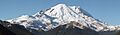
A panorama of the northeast face of Mount Rainier
See also
 In Spanish: Monte Rainier para niños
