
List of U.S. states and territories by elevation facts for kids


This article lists the heights of land in each of the 50 U.S. states, the District of Columbia, and the U.S. territories.
When we talk about how high a place is, we can describe it in a few ways:
- The highest spot in an area (its high point).
- The lowest spot in an area (its low point).
- The average height of all the land in an area.
- The middle height of all the land in an area.
- How much the height changes from the lowest to the highest point.
All the heights listed here are measured using a standard system called the North American Vertical Datum of 1988 (NAVD 88). The locations (coordinates) use the World Geodetic System of 1984 (WGS 84). The average heights for each state, Washington D.C., and Puerto Rico are very close to the real numbers, usually within about 100 feet. We don't have average height data for other U.S. territories.
Contents
Exploring High Points: What is Highpointing?
People who enjoy climbing to the highest point in every U.S. state and territory are called highpointers. It's a fun challenge to see how many high points you can reach!
How High is Each State?
This table shows the highest and lowest points for each of the 50 U.S. states, the District of Columbia, and the U.S. territories. It also includes their average height and how much the height changes from low to high.
| State, district, or territory | Highest point, rank & elevation | Lowest point, rank & elevation | Elevation: mean, range | High point coordinates | |||||||
|---|---|---|---|---|---|---|---|---|---|---|---|
| Cheaha Mountain | 38 | 2,405 ft 733 m |
Gulf of Mexico | 3 | sea level | 41 | 500 ft 150 m |
38 | 2,405 ft 733 m |
33°29′07″N 85°48′31″W / 33.4854°N 85.8086°W | |
| Denali | 1 | 20,310 ft 6190.5 m |
Gulf of Alaska, Bering Sea, and Arctic Ocean | 3 | sea level | 15 | 1,900 ft 580 m |
1 | 20,310 ft 6190.5 m |
63°04′08″N 151°00′23″W / 63.0690°N 151.0063°W | |
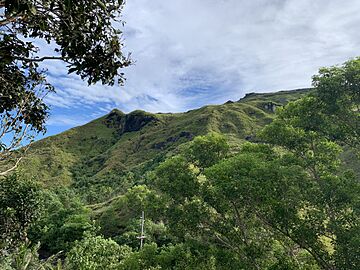
| Lata Mountain on Taʻū Island | 36 | 3,169 ft 966 m |
Pacific Ocean | 3 | sea level | NA | 35 | 3,169 ft 966 m |
14°13′59″S 169°27′15″W / 14.2331°S 169.4543°W | ||
| Humphreys Peak | 12 | 12,637 ft 3851.8 m |
Colorado River at Sonora border, San Luis, Arizona |
33 | 70 ft 21 m |
7 | 4,100 ft 1250 m |
6 | 12,567 ft 3830 m |
35°20′47″N 111°40′41″W / 35.3464°N 111.6780°W | |
| Mount Magazine | 37 | 2,753 ft 839 m |
Ouachita River at Louisiana border | 32 | 55 ft 17 m |
37 | 650 ft 200 m |
37 | 2,698 ft 822 m |
35°10′02″N 93°38′41″W / 35.1671°N 93.6447°W | |
| Mount Whitney | 2 | 14,505 ft 4421.0 m |
Badwater Basin in Death Valley | 1 | −282 ft −86 m |
11 | 2,900 ft 880 m |
2 | 14,787 ft 4507 m |
36°34′43″N 118°17′33″W / 36.5786°N 118.2924°W | |
| Mount Elbert | 3 | 14,440 ft 4401.2 m |
Arikaree River at Kansas border | 57 | 3,317 ft 1011 m |
1 | 6,800 ft 2070 m |
10 | 11,123 ft 3390 m |
39°07′04″N 106°26′43″W / 39.1178°N 106.4453°W | |
| Southern slope of Mount Frissell at Massachusetts border | 39 | 2,386 ft 727 m |
Long Island Sound | 3 | sea level | 41 | 500 ft 150 m |
39 | 2,386 ft 727 m |
42°02′59″N 73°28′58″W / 42.0496°N 73.4828°W | |
| Near the Ebright Azimuth | 54 | 449 ft 137 m |
Atlantic Ocean | 3 | sea level | 52 | 60 ft 20 m |
54 | 449 ft 137 m |
39°50′10″N 75°31′20″W / 39.8360°N 75.5222°W | |
| Point Reno | 55 | 414 ft 126 m |
Potomac River at eastern Maryland border | 31 | 1 ft 0.3 m |
49 | 150 ft 50 m |
55 | 413 ft 126 m |
38°57′06″N 77°04′34″W / 38.9517°N 77.0760°W | |
| Britton Hill | 56 | 345 ft 105 m |
Atlantic Ocean and Gulf of Mexico | 3 | sea level | 50 | 100 ft 30 m |
56 | 345 ft 105 m |
30°59′05″N 86°16′57″W / 30.9848°N 86.2824°W | |
| Brasstown Bald | 25 | 4,784 ft 1458 m |
Atlantic Ocean | 3 | sea level | 38 | 600 ft 180 m |
22 | 4,784 ft 1458 m |
34°52′28″N 83°48′40″W / 34.8744°N 83.8111°W | |
| Mount Lamlam | 48 | 1,332 ft 406 m |
Pacific Ocean | 3 | sea level | NA | 46 | 1,332 ft 406 m |
13°20′23″N 144°39′56″E / 13.3397°N 144.6655°E | ||
| Mauna Kea | 6 | 13,803 ft 4207.3 m |
Pacific Ocean | 3 | sea level | 10 | 3,030 ft 920 m |
4 | 13,803 ft 4207 m |
19°49′15″N 155°28′05″W / 19.8207°N 155.4680°W | |
| Borah Peak | 11 | 12,668 ft 3861.2 m |
Confluence of Snake and Clearwater rivers | 49 | 710 ft 216 m |
6 | 5,000 ft 1520 m |
7 | 11,958 ft 3645 m |
44°08′15″N 113°46′52″W / 44.1374°N 113.7811°W | |
| Charles Mound | 50 | 1,235 ft 376.4 m |
Confluence of Mississippi and Ohio rivers | 39 | 279 ft 85 m |
38 | 600 ft 180 m |
49 | 956 ft 291 m |
42°30′15″N 90°14′23″W / 42.5041°N 90.2398°W | |
| Hoosier Hill | 49 | 1,257 ft 383 m |
Confluence of Wabash and Ohio rivers | 41 | 320 ft 98 m |
34 | 795 ft 242 m |
50 | 937 ft 286 m |
40°00′04″N 84°50′55″W / 40.0012°N 84.8487°W | |
| Hawkeye Point | 45 | 1,671 ft 509 m |
Confluence of Mississippi and Des Moines rivers | 44 | 480 ft 146 m |
22 | 1,100 ft 340 m |
47 | 1,191 ft 363 m |
43°27′37″N 95°42′32″W / 43.4602°N 95.7089°W | |
| Mount Sunflower | 29 | 4,041 ft 1232 m |
Verdigris River at Oklahoma border | 48 | 679 ft 207 m |
14 | 2,000 ft 610 m |
32 | 3,362 ft 1025 m |
39°01′19″N 102°02′14″W / 39.0220°N 102.0371°W | |
| Black Mountain | 28 | 4,139 ft 1262 m |
Mississippi River at Kentucky Bend | 38 | 257 ft 78 m |
35 | 750 ft 230 m |
28 | 3,882 ft 1183 m |
36°54′51″N 82°53′38″W / 36.9142°N 82.8938°W | |
| Driskill Mountain | 53 | 535 ft 163 m |
New Orleans | 2 | −8 ft −2.4 m |
50 | 100 ft 30 m |
53 | 543 ft 166 m |
32°25′30″N 92°53′48″W / 32.4249°N 92.8967°W | |
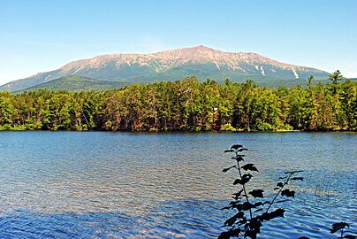
| Mount Katahdin | 22 | 5,270 ft 1606.4 m |
Atlantic Ocean | 3 | sea level | 38 | 600 ft 180 m |
21 | 5,270 ft 1606 m |
45°54′16″N 68°55′17″W / 45.9044°N 68.9214°W | |
| Hoye-Crest | 33 | 3,370 ft 1027 m |
Atlantic Ocean | 3 | sea level | 44 | 350 ft 110 m |
31 | 3,370 ft 1027 m |
39°14′15″N 79°29′08″W / 39.2374°N 79.4855°W | |
| Mount Greylock | 32 | 3,489 ft 1063 m |
Atlantic Ocean | 3 | sea level | 41 | 500 ft 150 m |
30 | 3,489 ft 1063 m |
42°38′14″N 73°09′57″W / 42.6373°N 73.1659°W | |
| Mount Arvon | 41 | 1,979 ft 603 m |
Lake Erie | 45 | 571 ft 174 m |
29 | 900 ft 270 m |
44 | 1,408 ft 429 m |
46°45′21″N 88°09′19″W / 46.7557°N 88.1553°W | |
| Eagle Mountain | 40 | 2,302 ft 702 m |
Lake Superior | 47 | 601 ft 183 m |
21 | 1,200 ft 370 m |
41 | 1,701 ft 518 m |
47°53′51″N 90°33′38″W / 47.8974°N 90.5606°W | |
| Woodall Mountain | 52 | 807 ft 246.0 m |
Gulf of Mexico | 3 | sea level | 46 | 300 ft 90 m |
52 | 807 ft 246 m |
34°47′16″N 88°14′30″W / 34.7877°N 88.2416°W | |
| Taum Sauk Mountain | 44 | 1,772 ft 540 m |
Saint Francis River at southern Arkansas border | 36 | 230 ft 70 m |
33 | 800 ft 240 m |
43 | 1,542 ft 470 m |
37°34′17″N 90°43′45″W / 37.5713°N 90.7291°W | |
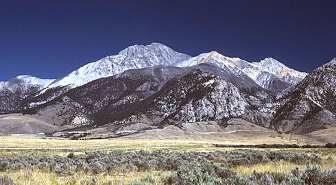
| Granite Peak | 10 | 12,807 ft 3903.5 m |
Kootenai River at Idaho border | 53 | 1,800 ft 549 m |
8 | 3,400 ft 1040 m |
11 | 11,007 ft 3355 m |
45°09′49″N 109°48′27″W / 45.1635°N 109.8076°W | |
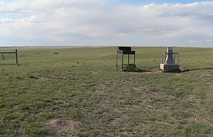
| Panorama Point | 20 | 5,432 ft 1656 m |
Missouri River at Kansas border | 51 | 840 ft 256 m |
12 | 2,600 ft 790 m |
25 | 4,592 ft 1400 m |
41°00′28″N 104°01′53″W / 41.0077°N 104.0314°W | |
| Boundary Peak | 9 | 13,147 ft 4007 m |
Colorado River at California border | 43 | 479 ft 146 m |
5 | 5,500 ft 1680 m |
5 | 12,668 ft 3861 m |
37°50′46″N 118°21′05″W / 37.8461°N 118.3514°W | |
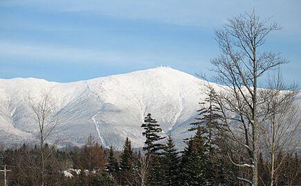
| Mount Washington | 18 | 6,285.8 ft 1915.92 m |
Atlantic Ocean (Gulf of Maine) | 3 | sea level | 25 | 1,000 ft 300 m |
17 | 6,286 ft 1916 m |
44°16′14″N 71°18′12″W / 44.2705°N 71.3034°W | |
| High Point | 43 | 1,802 ft 549 m |
Atlantic Ocean | 3 | sea level | 47 | 250 ft 80 m |
40 | 1,802 ft 549 m |
41°19′15″N 74°39′42″W / 41.3209°N 74.6616°W | |
| Wheeler Peak | 8 | 13,167 ft 4013.3 m |
Red Bluff Reservoir on Texas border | 55 | 2,842 ft 866 m |
4 | 5,700 ft 1740 m |
13 | 10,325 ft 3147 m |
36°33′24″N 105°25′01″W / 36.5568°N 105.4169°W | |
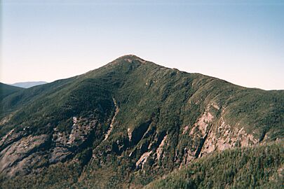
| Mount Marcy | 21 | 5,343 ft 1628.57 m |
Atlantic Ocean | 3 | sea level | 25 | 1,000 ft 300 m |
20 | 5,343 ft 1629 m |
44°06′46″N 73°55′26″W / 44.1129°N 73.9238°W | |
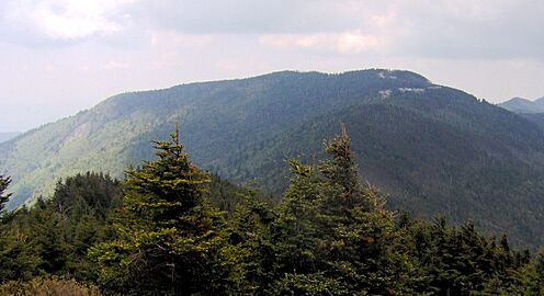
| Mount Mitchell | 16 | 6,684 ft 2037 m |
Atlantic Ocean | 3 | sea level | 36 | 700 ft 210 m |
15 | 6,684 ft 2037 m |
35°45′54″N 82°15′54″W / 35.7649°N 82.2651°W | |
| White Butte | 31 | 3,506 ft 1069 m |
Red River of the North at Manitoba border | 50 | 750 ft 229 m |
15 | 1,900 ft 580 m |
36 | 2,756 ft 840 m |
46°23′13″N 103°18′10″W / 46.3870°N 103.3027°W | |
| Mount Agrihan on the island of Agrihan | 35 | 3,204 ft 977 m |
Pacific Ocean | 3 | sea level | NA | 34 | 3,204 ft 977 m |
18°46′05″N 145°40′24″E / 18.7681°N 145.6732°E | ||
| Campbell Hill | 47 | 1,548 ft 472 m |
Ohio River at Indiana border | 42 | 455 ft 139 m |
32 | 850 ft 260 m |
48 | 1,093 ft 333 m |
40°22′13″N 83°43′12″W / 40.3703°N 83.7201°W | |
| Black Mesa | 23 | 4,975 ft 1516 m |
Little River at Arkansas border | 40 | 289 ft 88 m |
20 | 1,300 ft 400 m |
23 | 4,686 ft 1428 m |
36°55′54″N 102°59′52″W / 36.9318°N 102.9979°W | |
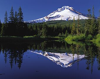
| Mount Hood | 13 | 11,249 ft 3428.8 m |
Pacific Ocean | 3 | sea level | 9 | 3,300 ft 1010 m |
9 | 11,249 ft 3429 m |
45°22′25″N 121°41′46″W / 45.3735°N 121.6960°W | |
| Mount Davis | 34 | 3,213 ft 979 m |
Delaware River at Delaware border | 3 | sea level | 22 | 1,100 ft 340 m |
33 | 3,213 ft 979 m |
39°47′10″N 79°10′36″W / 39.7860°N 79.1768°W | |
| Cerro de Punta | 27 | 4,390 ft 1338 m |
Atlantic Ocean (Caribbean sea) | 3 | sea level | 31 | 856 ft 261 m |
26 | 4,390 ft 1338 m |
18°10′20″N 66°35′30″W / 18.1722°N 66.5917°W | |
| Jerimoth Hill | 51 | 811 ft 247 m |
Atlantic Ocean | 3 | sea level | 48 | 200 ft 60 m |
51 | 811 ft 247 m |
41°50′57″N 71°46′44″W / 41.8493°N 71.7789°W | |
| Sassafras Mountain | 30 | 3,554 ft 1083 m |
Atlantic Ocean | 3 | sea level | 44 | 350 ft 110 m |
29 | 3,554 ft 1083 m |
35°03′54″N 82°46′38″W / 35.0651°N 82.7773°W | |
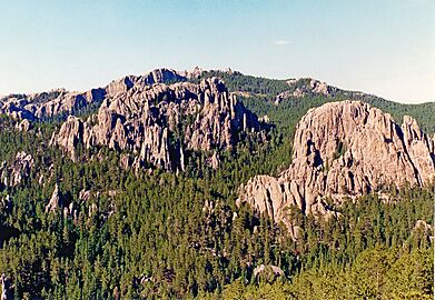
| Black Elk Peak | 15 | 7,244 ft 2208 m |
Big Stone Lake on Minnesota border | 52 | 966 ft 294 m |
13 | 2,200 ft 670 m |
18 | 6,278 ft 1914 m |
43°51′58″N 103°31′52″W / 43.8660°N 103.5312°W | |
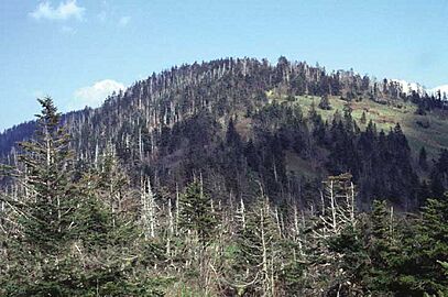
| Clingmans Dome | 17 | 6,643 ft 2025 m |
Mississippi River at Mississippi border | 35 | 178 ft 54 m |
29 | 900 ft 270 m |
16 | 6,465 ft 1971 m |
35°33′46″N 83°29′55″W / 35.5629°N 83.4986°W | |
| Guadalupe Peak | 14 | 8,751 ft 2667.4 m |
Gulf of Mexico | 3 | sea level | 17 | 1,700 ft 520 m |
14 | 8,751 ft 2667 m |
31°53′29″N 104°51′39″W / 31.8915°N 104.8607°W | |
| Kings Peak | 7 | 13,534 ft 4125 m |
Beaver Dam Wash at Arizona border | 54 | 2,000 ft 610 m |
3 | 6,100 ft 1860 m |
8 | 11,534 ft 3516 m |
40°46′35″N 110°22′22″W / 40.7763°N 110.3729°W | |
| Mount Mansfield | 26 | 4,395.3 ft 1339.69 m |
Lake Champlain | 34 | 95 ft 29 m |
25 | 1,000 ft 300 m |
27 | 4,300 ft 1311 m |
44°32′38″N 72°48′52″W / 44.5438°N 72.8144°W | |
| Crown Mountain on the island of Saint Thomas | 46 | 1,556 ft 474 m |
Atlantic Ocean (Caribbean Sea) | 3 | sea level | NA | 42 | 1,556 ft 474 m |
18°21′26″N 64°58′24″W / 18.3571°N 64.9732°W | ||
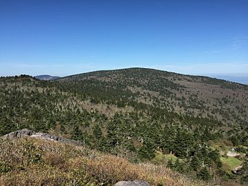
| Mount Rogers | 19 | 5,711 ft 1740.6 m |
Atlantic Ocean | 3 | sea level | 28 | 950 ft 290 m |
19 | 5,711 ft 1741 m |
36°39′36″N 81°32′42″W / 36.6601°N 81.5449°W | |
| Mount Rainier | 4 | 14,417 ft 4394 m |
Pacific Ocean | 3 | sea level | 17 | 1,700 ft 520 m |
3 | 14,417 ft 4394 m |
46°51′10″N 121°45′37″W / 46.8529°N 121.7604°W | |
| Spruce Knob | 24 | 4,862 ft 1482 m |
Potomac River at Virginia border | 37 | 240 ft 73 m |
19 | 1,500 ft 460 m |
24 | 4,622 ft 1409 m |
38°41′59″N 79°31′59″W / 38.6998°N 79.5330°W | |
| Timms Hill | 42 | 1,951 ft 595 m |
Lake Michigan | 46 | 579 ft 176 m |
24 | 1,050 ft 320 m |
45 | 1,372 ft 418 m |
45°27′03″N 90°11′43″W / 45.4508°N 90.1954°W | |
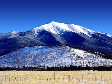
| Gannett Peak | 5 | 13,809 ft 4209.1 m |
Belle Fourche River at South Dakota border | 56 | 3,101 ft 945 m |
2 | 6,700 ft 2040 m |
12 | 10,709 ft 3264 m |
43°11′04″N 109°39′15″W / 43.1844°N 109.6543°W | |
| Navassa Island high point | 57 | 280 ft 85 m |
Navassa Island in the Caribbean Sea and other islands in the Pacific Ocean | 3 | sea level | NA | 57 | 280 ft 85 m |
18°23′48″N 75°00′45″W / 18.3968°N 75.0125°W | ||
Small Islands: Highest Points
Here are the highest points on some of the smaller U.S. islands that are far away from the main land:
- Baker Island high point – 26 feet
- Howland Island high point – 10 feet
- Jarvis Island high point – 23 feet
- Johnston Atoll, Sand Island high point – 33 feet
- Kingman Reef high point – less than 7 feet
- Midway Atoll, Sand Island high point – 50 feet – This is the highest point among the U.S. minor outlying islands in the Pacific Ocean.
- Navassa Island high point – 280 feet – This is the highest point of all the U.S. minor outlying islands.
- Palmyra Atoll high point – 10 feet
- Wake Island high point – 26 feet
Images for kids
-
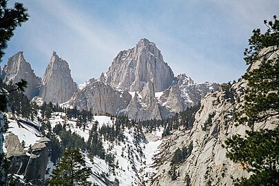
2. Mount Whitney in California
-
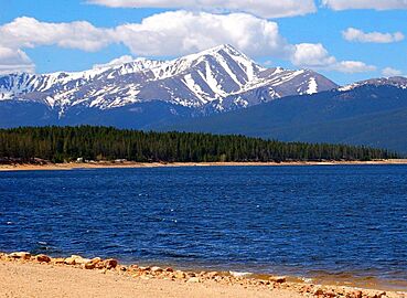
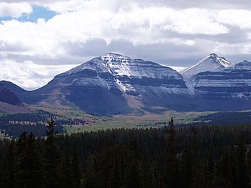
3. Mount Elbert in Colorado
-
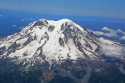
4. Mount Rainier in Washington
-
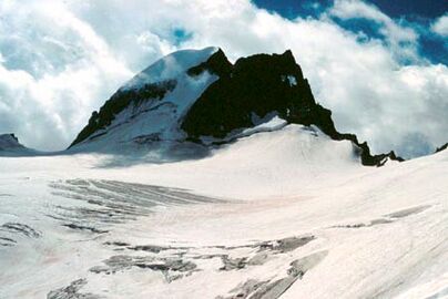
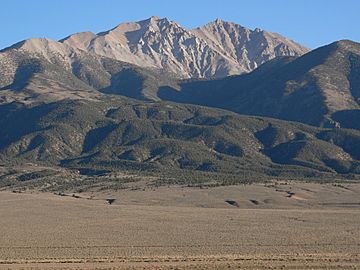
5. Gannett Peak in Wyoming
-
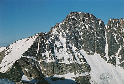
7. Kings Peak in Utah
-
8. Wheeler Peak in New Mexico
-
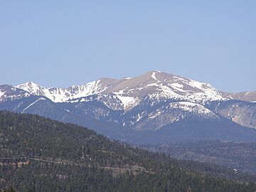
9. Boundary Peak in Nevada
-
10. Granite Peak in Montana
-
11. Borah Peak in Idaho.
-
12. Humphreys Peak in Arizona
-
13. Mount Hood in Oregon
-

14. Guadalupe Peak in Texas
-
15. Black Elk Peak in South Dakota
-
16. Mount Mitchell in North Carolina
-
17. Clingmans Dome in Tennessee
-
18. Mount Washington in New Hampshire
-
19. Mount Rogers in Virginia
-
20. Panorama Point in Nebraska
-
21. Mount Marcy in New York
-
22. Mount Katahdin in Maine
-
23. Mount Lamlam in Guam
-
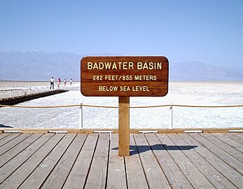
The Badwater Basin in Death Valley is the lowest point in all of North America.


See also
 In Spanish: Anexo:Estados de los Estados Unidos por altitud para niños
- Highpointing
- List of elevation extremes by country
- List of elevation extremes by region
- Lists of highest points
- List of highest counties in the United States
- List of highest United States cities by state
