Mount Mitchell facts for kids
Quick facts for kids Mount Mitchell |
|
|---|---|

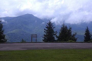
Mount Mitchell, viewed from the Blue Ridge Parkway in North Carolina
|
|
| Highest point | |
| Elevation | 6,684 ft (2,037 m) |
| Prominence | 6,089 ft (1,856 m) |
| Isolation | 1,189 miles (1,914 km) |
| Listing |
|
| Geography | |
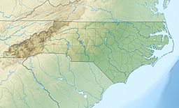
| Location | Yancey County, North Carolina, U.S. |
| Parent range | Appalachian Mountains |
| Topo map | USGS Mount Mitchell |
| Climbing | |
| Easiest route | Hike |
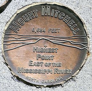
Mount Mitchell is a very special mountain in North Carolina. It's the tallest peak in the entire Appalachian Mountains. It's also the highest point in mainland North America east of the Mississippi River!
The Cherokee people, who lived here for a long time, called the mountain Attakulla. Today, it's named after Elisha Mitchell, a professor who studied the area. Mount Mitchell stands 6,684 feet (2,037 m) above sea level. It's protected as Mount Mitchell State Park and surrounded by the Pisgah National Forest.
Contents
Exploring Mount Mitchell
Mount Mitchell is the highest mountain in the United States east of the Mississippi River. It's also the tallest in all of eastern North America, south of the very cold Canadian Arctic. The closest mountains that are taller are far away in South Dakota and Colorado.
You can reach the top of Mount Mitchell by driving along a road called North Carolina Highway 128. This road connects to the beautiful Blue Ridge Parkway. From the parking lot, a short, paved trail leads you through a forest to the very summit. There's a tall stone observation deck at the top. It was built in 2009 and offers amazing views!
The History of Mount Mitchell
Mount Mitchell was once considered the highest mountain in the United States. This was before the country grew bigger with the Louisiana Purchase in 1803. After that, other taller mountains in the west became part of the U.S.
Early European settlers called this mountain Black Dome because of its round shape. Later, it was named after Elisha Mitchell. He was a professor at the University of North Carolina. In 1835, he explored the Black Mountain area. He figured out that these mountains were taller than Mount Washington in New Hampshire. At that time, Mount Washington was thought to be the highest peak in the eastern U.S. Sadly, Professor Mitchell died in 1857 near Mitchell Falls while checking his measurements.
The Mountain's Environment
The top of Mount Mitchell is covered in a special kind of forest. It's called a Southern Appalachian spruce-fir forest. This forest has two main types of evergreen trees: the red spruce and the Fraser fir.
However, many of the older Fraser fir trees have been harmed. A tiny insect called the Balsam woolly adelgid caused a lot of damage in the late 1900s. Also, the high elevation means the trees are exposed to a lot of air pollution. This pollution includes acid precipitation, which is like acid rain, snow, and fog. These acids can hurt the red spruce trees. They release natural metals from the soil and wash away important minerals. Scientists are still studying how much this pollution affects the mountain's ecosystem.
Even with these challenges, the mountain is still green and beautiful in the summer. You might see some dead fir trees, but many young fir and spruce trees are growing. Wildflowers bloom all summer long. Birds enjoy eating the cones from the trees, as well as wild blueberry and blackberry bushes.
Just about a mile north of Mount Mitchell is Mount Craig. It's the second-highest point in eastern North America, standing at 6,647 feet (2,026 m).
Mount Mitchell's Climate
| Weather chart for Mount Mitchell | |||||||||||||||||||||||||||||||||||||||||||||||
|---|---|---|---|---|---|---|---|---|---|---|---|---|---|---|---|---|---|---|---|---|---|---|---|---|---|---|---|---|---|---|---|---|---|---|---|---|---|---|---|---|---|---|---|---|---|---|---|
| J | F | M | A | M | J | J | A | S | O | N | D | ||||||||||||||||||||||||||||||||||||
|
6.5
33
17
|
5.9
35
18
|
7.1
41
24
|
5.7
49
31
|
5.3
57
41
|
5.7
63
49
|
5.8
66
52
|
7.2
65
52
|
7.5
60
46
|
5.1
53
37
|
6.7
45
28
|
6.2
36
21
|
||||||||||||||||||||||||||||||||||||
| temperatures in °F precipitation totals in inches source: NOAA |
|||||||||||||||||||||||||||||||||||||||||||||||
|
Metric conversion
|
|||||||||||||||||||||||||||||||||||||||||||||||
The weather at the top of Mount Mitchell is quite different from the areas around it. It has mild summers and long, pretty cold winters. It's more like the climate in southeastern Canada than in the southern U.S. The average temperature in January is about 25.1 °F (−3.8 °C), and in July, it's around 59.6 °F (15.3 °C).
The coldest temperature ever recorded in North Carolina happened here. On January 21, 1985, it dropped to a freezing −34 °F (−36.7 °C)! Mount Mitchell is also the coldest place in the state on average, with a yearly average temperature of 42.9 °F (6.1 °C).
Heavy snow often falls from December to March. For example, in the Great Blizzard of 1993, 50 inches (1.27 m) of snow fell. In the January 2016 blizzard, there was 33 inches (0.84 m). The mountain gets a lot of rain and snow all year, averaging over 81 inches (2,057 mm) annually. It's also often very windy at the summit, with gusts recorded up to 178 mph (286 km/h).
In 2018, Mount Mitchell set a new state record for rainfall. It received 139.94 inches (3,554.5 mm) of precipitation. This was also the highest total rainfall recorded in a calendar year anywhere east of the Cascade Range in the Contiguous United States.
| Climate data for Mount Mitchell, North Carolina (1991–2020 normals, extremes 1980–present) | |||||||||||||
|---|---|---|---|---|---|---|---|---|---|---|---|---|---|
| Month | Jan | Feb | Mar | Apr | May | Jun | Jul | Aug | Sep | Oct | Nov | Dec | Year |
| Record high °F (°C) | 61 (16) |
62 (17) |
73 (23) |
73 (23) |
78 (26) |
79 (26) |
80 (27) |
81 (27) |
77 (25) |
73 (23) |
67 (19) |
64 (18) |
81 (27) |
| Mean maximum °F (°C) | 51.0 (10.6) |
52.3 (11.3) |
58.6 (14.8) |
66.6 (19.2) |
69.6 (20.9) |
72.7 (22.6) |
74.0 (23.3) |
73.3 (22.9) |
70.8 (21.6) |
66.5 (19.2) |
59.0 (15.0) |
53.5 (11.9) |
75.2 (24.0) |
| Mean daily maximum °F (°C) | 33.5 (0.8) |
35.5 (1.9) |
41.0 (5.0) |
50.2 (10.1) |
57.8 (14.3) |
63.8 (17.7) |
66.8 (19.3) |
66.0 (18.9) |
61.4 (16.3) |
53.6 (12.0) |
44.8 (7.1) |
37.7 (3.2) |
51.0 (10.6) |
| Daily mean °F (°C) | 25.1 (−3.8) |
27.0 (−2.8) |
32.3 (0.2) |
41.1 (5.1) |
49.5 (9.7) |
56.3 (13.5) |
59.6 (15.3) |
58.6 (14.8) |
53.8 (12.1) |
45.2 (7.3) |
36.2 (2.3) |
29.6 (−1.3) |
42.9 (6.1) |
| Mean daily minimum °F (°C) | 16.7 (−8.5) |
18.5 (−7.5) |
23.6 (−4.7) |
32.0 (0.0) |
41.3 (5.2) |
48.7 (9.3) |
52.3 (11.3) |
51.2 (10.7) |
46.2 (7.9) |
36.9 (2.7) |
27.6 (−2.4) |
21.4 (−5.9) |
34.7 (1.5) |
| Mean minimum °F (°C) | −6.5 (−21.4) |
−0.7 (−18.2) |
3.9 (−15.6) |
14.7 (−9.6) |
26.2 (−3.2) |
38.9 (3.8) |
45.4 (7.4) |
45.5 (7.5) |
35.2 (1.8) |
19.8 (−6.8) |
9.2 (−12.7) |
1.6 (−16.9) |
−9.5 (−23.1) |
| Record low °F (°C) | −34 (−37) |
−23 (−31) |
−15 (−26) |
1 (−17) |
13 (−11) |
27 (−3) |
36 (2) |
32 (0) |
23 (−5) |
5 (−15) |
−19 (−28) |
−22 (−30) |
−34 (−37) |
| Average precipitation inches (mm) | 7.47 (190) |
5.62 (143) |
7.22 (183) |
6.52 (166) |
6.08 (154) |
5.46 (139) |
6.92 (176) |
7.69 (195) |
8.76 (223) |
6.29 (160) |
6.17 (157) |
6.89 (175) |
81.09 (2,060) |
| Average snowfall inches (cm) | 19.2 (49) |
18.6 (47) |
18.5 (47) |
7.1 (18) |
1.4 (3.6) |
0.0 (0.0) |
0.0 (0.0) |
0.0 (0.0) |
0.0 (0.0) |
0.7 (1.8) |
3.9 (9.9) |
19.7 (50) |
89.1 (226) |
| Average precipitation days (≥ 0.01 in) | 14.1 | 12.4 | 14.1 | 12.6 | 14.2 | 16.1 | 17.8 | 16.1 | 12.7 | 10.3 | 10.4 | 13.1 | 163.9 |
| Average snowy days (≥ 0.1 in) | 6.4 | 6.5 | 4.9 | 2.5 | 0.3 | 0.0 | 0.0 | 0.0 | 0.0 | 0.4 | 2.0 | 5.2 | 28.2 |
| Source: NOAA | |||||||||||||
More to See
- Assault on Mount Mitchell, a challenging bike ride
- List of mountains in North Carolina
- Mountains-to-Sea Trail
See also
 In Spanish: Monte Mitchell para niños
 | Ernest Everett Just |
 | Mary Jackson |
 | Emmett Chappelle |
 | Marie Maynard Daly |


