
Blue Ridge Parkway facts for kids
Quick facts for kids
[[File:|x70px|alt= marker]] |
|
|---|---|
|
Blue Ridge Parkway route map
|
|
| Route information | |
| Length | 469 mi (755 km) |
| Existed | June 30, 1936–present |
| Tourist routes |
|
| Restrictions | No commercial vehicles |
| Major junctions | |
| North end | |
|
|
| South end | |
| Location | |
| States: | Virginia, North Carolina |
| Highway system | |
|
IUCN Category V (Protected Landscape/Seascape)
|
|

Ice Rock Milepost 242
|
|
| Location | North Carolina & Virginia, USA |
| Nearest city | Asheville, NC & Roanoke, VA |
| Area | 93,390 acres (377.9 km2) |
| Established | June 30, 1936 |
| Visitors | 16,757,635 (in 2023) |
| Governing body | National Park Service |
| Website | Blue Ridge Parkway |
The Blue Ridge Parkway is a super long and beautiful road in the United States. It's known for its amazing views of mountains and forests. This special road is like a park that stretches for 469 miles (755 km). It goes through 29 counties in Virginia and North Carolina.
The parkway connects two big national parks: Shenandoah National Park and Great Smoky Mountains National Park. It mostly follows the top of the Blue Ridge Mountains, which are part of the larger Appalachian Mountains. The southern end of the parkway is near Cherokee, North Carolina. From there, it travels north to Shenandoah National Park in Virginia.
The road continues through Shenandoah National Park as Skyline Drive. This is another scenic road, but it's managed by a different part of the National Park Service. The Blue Ridge Parkway is one of the most visited places in the National Park System.
The land along the parkway is owned and cared for by the National Park Service. You don't have to pay to drive on the parkway. However, big trucks and commercial vehicles usually aren't allowed without special permission.
During winter, the parkway isn't always kept clear of snow and ice. Parts of it that go over high mountains or through tunnels often close from late fall to early spring. The weather in the mountains can change very quickly! The speed limit on the parkway is usually 45 miles per hour (72 km/h) or less.
Besides the road itself, there are cool places to visit. There's a folk art center and a visitor center near Asheville, North Carolina. You can also find many parking areas for hiking trails and several campgrounds for overnight stays. The Blue Ridge Music Center is another fun stop, and Mount Mitchell, the tallest mountain in eastern North America, is also nearby.
Contents
Exploring the Parkway: What You'll See

The Blue Ridge Parkway stretches from Rockfish Gap in Virginia to Oconaluftee in the Great Smoky Mountains National Park in North Carolina. For most of its length, it's a two-lane road without a divider.
The parkway is designed so you can enjoy nature without many stops. It has special exits to connect with local roads and highways. It crosses over many streams and roads using 168 bridges and six big bridges called viaducts. Along the way, you'll find lots of pull-offs and scenic overlooks where you can stop and enjoy the view.
The road avoids big towns and cities, so you can really feel like you're in nature. It's meant to be an attraction itself, not just a way to get somewhere fast. Mile markers help you know where you are, starting at zero in Virginia and going up to 469 in North Carolina.
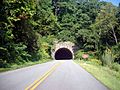
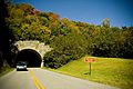
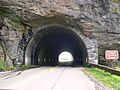
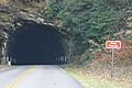
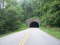
Major towns near the parkway include Waynesboro, Roanoke, and Galax in Virginia. In North Carolina, you'll find Boone and Asheville. The parkway even goes through the famous Biltmore Estate property near Asheville. There are 26 tunnels carved through the mountains, which are pretty cool to drive through!
Cold Weather on the Parkway
Many parts of the parkway are very high up in the mountains. This means it can be colder, wetter, and windier than in the areas around it. The highest point on the parkway is 6,053 feet (1,845 meters) above sea level at Richland Balsam in North Carolina.
Sometimes, parts of the parkway close temporarily for repairs. This often happens because of damage from the cold winter weather. The parkway tries not to use too many chemicals to melt ice, so some areas might stay closed for a while. If a section is closed, you'll need to find a different route.
Cool Spots in Virginia

- Mile 0 - Rockfish Gap: This is where the Blue Ridge Parkway begins in the north. It connects right to Skyline Drive, which goes through Shenandoah National Park.
- Mile 5 to 9.3 - Humpback Rock: Here, you can walk a trail through old Appalachian farm buildings. A hike from the parking area leads to "The Rocks," which look like a camel's hump!
- Mile 10.7 - Ravens Roost: This spot offers amazing views of Torry Mountain and the Shenandoah Valley. It's even a popular place for rock climbing and hang gliding.
- Mile 63.8 - James River and Kanawha Canal: You can walk across a footbridge here to see old canal locks and learn about their history.
- Mile 84 to 87 - Peaks of Otter: These three mountain peaks have been famous for their views since the time of Thomas Jefferson.
- Mile 176.1 - Mabry Mill: This old mill was run by E.B. Mabry from 1910 to 1935. You can see his gristmill, sawmill, and blacksmith shop. Sometimes, people show how old-time skills were done.
Cool Spots in North Carolina

The Blue Ridge Parkway crosses into North Carolina at mile 216.9.
- Mile 217.5 - Cumberland Knob: This is a small recreation area on the parkway, offering nice views.
- Mile 218.6 - Fox Hunters Paradise: Take a short walk here to imagine hunters listening to their dogs in the valley below.
- Mile 238.5 - Brinegar Cabin: This old cabin was built around 1880 and is still standing today.
- Mile 238.5 to 244.7 - Doughton Park: This park has many hiking trails, a lodge, a restaurant, and a campground.
- Mile 292 to 295 - Moses H. Cone Memorial Park: You can go hiking, fishing, or even horseback riding here. The old house, Flat Top Manor, is now a craft center.
- Mile 295.1 to 298 - Julian Price Memorial Park: This park has hiking trails, a campground, and Price Lake. It's the only lake on the parkway where you can go paddling!
- Mile 304.4 - Linn Cove Viaduct: This is a very famous part of the parkway. It's a special bridge that curves around Grandfather Mountain. There's a visitor center nearby where you can learn about it.
- Mile 316.3 - Linville Falls Recreation Area: Here, you can find trails that lead to amazing views of Linville Falls and the Linville Gorge.
- Mile 355.4 - Mount Mitchell State Park: Take a side road to reach Mount Mitchell, which is the highest point east of the Mississippi River!
- Mile 363.4 to 369.6 - Craggy Gardens: In mid-to-late June, these mountains are covered in beautiful purple rhododendron flowers.
- Mile 382 - The Folk Art Center: This center shows and sells traditional and modern crafts from the Appalachian region. You can see exhibits and watch people demonstrate crafts.
- Mile 431 - Richland Balsam: This is the highest point on the entire parkway, at 6,053 feet (1,845 meters) high! There's a trail that goes through a special spruce-fir forest here.
- Mile 469 - Southern End: The parkway ends here, connecting with U.S. 441 near Cherokee, North Carolina, in Great Smoky Mountains National Park.
Parkway History: Building a Scenic Road

The idea for the Blue Ridge Parkway started during President Franklin D. Roosevelt's time. It was first called the Appalachian Scenic Highway. The goal was to connect Shenandoah National Park and Great Smoky Mountains National Park.
Construction began on September 11, 1935, in North Carolina. Work in Virginia started a few months later. On June 30, 1936, Congress officially named it the Blue Ridge Parkway. It was put under the care of the National Park Service.
Many people worked on building the parkway, especially during the New Deal programs. These programs helped create jobs during a tough economic time. Groups like the Civilian Conservation Corps (CCC) helped clean up roadsides, plant trees, and improve the land. During World War II, conscientious objectors took over some of this work.
Building the parkway created jobs, but it also meant that some people had to move from their homes. New rules were made for landowners, like needing permission to build. Farmers couldn't use the parkway for commercial travel.
The Eastern Band of Cherokee Indians were also affected because the parkway went through their lands. They worked hard to get fair terms from the U.S. government for their land.
Most of the parkway was finished by 1966. But one tricky part, the 7.7-mile (12.4 km) section with the Linn Cove Viaduct around Grandfather Mountain, wasn't finished until 1987. The whole project took over 52 years to complete!
In 2004, Hurricane Frances and Hurricane Ivan caused a lot of damage, closing many parts of the parkway for a long time. More recently, in September 2024, Hurricane Helene caused widespread damage, leading to the closure of the entire parkway. Sections began to reopen in October 2024, but some parts remained closed through April 2025 for repairs.
Nature on the Parkway: Plants and Animals
The Blue Ridge Parkway is a fantastic place to see nature change throughout the year. In spring, you'll see lots of flowering shrubs and wildflowers like rhododendrons and dogwoods. These flowers bloom first in the valleys and then move up the mountains as the weather gets warmer.
Smaller flowers like daisies and asters bloom all summer long. In the fall, usually in September and October, the leaves on the trees turn brilliant colors. It's a spectacular sight! Sometimes, in spring and fall, you can look down from the parkway and see all three seasons at once: cold and windy at the top, with green and warm valleys below.
Common trees at lower elevations include oak, hickory, and tulip tree. Higher up, you'll find buckeye and ash, and at the very highest points, fir and spruce trees. Trees on ridges and peaks can look twisted and bent because of the strong winds and ice in winter.
Tunnels Along the Way
 |
|
| Bluff Mountain Tunnel | |
| Overview | |
|---|---|
| Location | Blue Ridge Parkway |
| Route | Blue Ridge Parkway |
| Operation | |
| Work begun | 1930s |
| Technical | |
| Construction | stone and concrete |
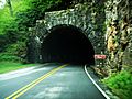
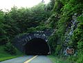
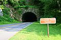
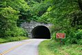
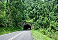
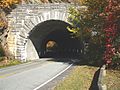
There are 26 tunnels on the Blue Ridge Parkway. Only one, the Bluff Mountain Tunnel, is in Virginia. The other twenty-five are in North Carolina, where the mountains are more rugged.
These tunnels were built to avoid cutting huge scars into the mountainsides. They help the road blend in with the natural landscape. Most of the tunnel digging was done by hand in the 1930s by the Civilian Conservation Corps. This created jobs during a time when many people needed work. They used drills and dynamite to blast through the rock.
Sometimes, concrete was added to the tunnels to prevent cave-ins and to make them brighter inside. This also helped stop moisture from getting in, which could cause ice problems in winter.
The longest tunnel on the parkway is the Pine Mountain Tunnel, which is 1,434 feet (437 meters) long. The tunnels often have cool stone entrances that were added later to make them look even better.
Gallery
-
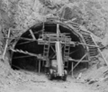
Tunnel construction in the 1930s
-
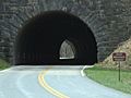
Bluff Mountain Tunnel
-
Craggy Flats Tunnel
-
Devil's Courthouse Tunnel
-
Young Pisgah Ridge Tunnel
-
Fryingpan Tunnel
-
Craggy Pinnacle Tunnel
-
Twin Tunnels
-
Grassy Knob Tunnel
-
Bunche's Bald Tunnel
-
Rattlesnake Mountain Tunnel
-
Little Switzerland Tunnel
-
Rough Ridge Tunnel


See also
- Natchez Trace Parkway
- Cherohala Skyway
- Foothills Parkway
