
Rockfish Gap facts for kids
Quick facts for kids Rockfish Gap |
|
|---|---|

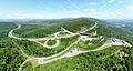
Aerial view of Rockfish Gap showing the junction of I-64, US-250 and Blue Ridge Parkway.
|
|
| Elevation | 1,903 ft (580 m) |
| Traversed by | |
| Location | Border of Augusta and Nelson counties, Virginia, United States |
| Range | Blue Ridge Mountains |
| Coordinates | 38°01′57″N 78°51′29″W / 38.0324°N 78.8580°W |
| Topo map | Waynesboro East |

Location in Virginia
|
|
Rockfish Gap is a special low spot, called a wind gap, in the Blue Ridge Mountains of Virginia. It sits between the cities of Charlottesville and Waynesboro. People often call this area "Afton Mountain" because the gap cuts through it.
This important gap connects the Shenandoah Valley to the Piedmont region of Virginia. It's where major roads like Interstate 64 and U.S. Route 250 cross the mountains. An old railroad line, once part of the Chesapeake and Ohio Railway, also goes through here. Rockfish Gap is about 1,900 feet (579 meters) high. It's one of the lowest mountain crossings in this part of the Blue Ridge. Water on one side flows towards the James River, while water on the other side flows into the Shenandoah River system.
Two famous scenic roads meet near Rockfish Gap. The Skyline Drive goes north through Shenandoah National Park. The Blue Ridge Parkway goes south towards North Carolina. Both roads follow the tops of the mountains. The long-distance Appalachian Trail also passes right through Rockfish Gap, making it a busy spot for hikers.
Contents
What is Rockfish Gap Made Of?
Rockfish Gap is built on ancient rocks called greenstones. These rocks are part of the Catoctin Formation. They can be found all over the Blue Ridge Mountains. These greenstones were once hot lava flows about 550 to 565 million years ago. Over time, they changed into the rock we see today.
Rockfish Gap is located where the rock has cracks and breaks. These broken areas wear away more easily than solid rock. This is likely why the gap formed in this exact spot, making it a natural pathway through the mountains.
A Look Back: History of Rockfish Gap
In the 1700s, Native Americans used trails through Rockfish Gap. These trails helped early Virginia settlers move westward. By the 1740s, a main road called the Three Notch'd Road connected Richmond to the Shenandoah Valley. This road likely followed an old Monacan tribe trail. It was well-planned, with inns about every 10 miles. By 1782, horse-drawn carriages could cross the Blue Ridge at Rockfish Gap.
In 1818, some very important people met at a tavern in Rockfish Gap. These included President James Monroe, former presidents Thomas Jefferson and James Madison, and Chief Justice John Marshall. They decided that Charlottesville would be the home of the new University of Virginia. This shows how important Rockfish Gap was as a meeting place.
In 1854, a German artist named Edward Beyer painted a picture of Rockfish Gap and the Mountain House tavern.
Railroads and Roads Through the Gap
In the 1850s, a man named Claudius Crozet oversaw the building of a railroad tunnel under Rockfish Gap. This was for the Blue Ridge Railroad. During the American Civil War, Confederate General Stonewall Jackson used this tunnel to move his soldiers. Later, a new tunnel was built for the Chesapeake and Ohio Railway. Today, CSX Transportation owns the railroad line.
The old tunnel is still there! In November 2020, it was opened to the public as a trail for walking and biking.

In the early 1900s, U.S. Route 250 was built across the gap. Then, in the 1970s, parts of the new Interstate 64 were finished, also crossing Afton Mountain at Rockfish Gap.
Driving Safely in Foggy Conditions
Rockfish Gap can sometimes have very thick fog, especially on Interstate 64. This fog can make driving difficult. To help drivers, the Virginia Department of Transportation (VDOT) put in a special lighting system. This system has lights in the road that turn on automatically when fog sensors detect low visibility. This helps drivers see the lanes better and stay safe.
Images for kids
-
Aerial view of Rockfish Gap showing the junction of I-64, US-250 and Blue Ridge Parkway.
-
Location of Rockfish Gap within Virginia
-
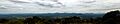
Rockfish Gap viewpoint

