Waynesboro, Virginia facts for kids
Quick facts for kids
Waynesboro, Virginia
|
|
|---|---|

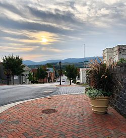
Downtown Waynesboro showing Main Street looking East
|
|

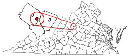
Location of Waynesboro, Virginia
|
|
| Country | United States |
| State | Virginia |
| Area | |
| • Total | 15.11 sq mi (39.14 km2) |
| • Land | 14.97 sq mi (38.77 km2) |
| • Water | 0.14 sq mi (0.36 km2) |
| Elevation | 1,286 ft (392 m) |
| Population
(2020)
|
|
| • Total | 22,196 |
| • Density | 1,469.0/sq mi (567.09/km2) |
| Time zone | UTC−5 (Eastern (EST)) |
| • Summer (DST) | UTC−4 (EDT) |
| ZIP code |
22980
|
| Area code(s) | 540 |
| FIPS code | 51-83680 |
| GNIS feature ID | 1500288 |
| Website | Official Website: http://www.waynesboro.va.us/ |
Waynesboro (pronounced "WAYNZ-buh-roh") is a city in Virginia, USA. It's called an independent city because it's not part of any county. Waynesboro is located in the beautiful Shenandoah Valley. The city is surrounded by Augusta County. In 2020, about 22,196 people lived there.
Contents
History of Waynesboro
Waynesboro is in what used to be the British Colony of Virginia. Even after the American Revolution, the areas west of the Appalachian Mountains were considered the frontier. Traveling over these mountains was very hard.
How Waynesboro Got Its Name
In the mid-1700s, the Waynesboro area was known as Teasville. After U.S. Army General Anthony Wayne won an important battle in 1794, the area started to be called Waynesborough. Many settlers came from Pennsylvania, and General Wayne was very popular there. This is likely why the town was named after him.
Early Days and Growth
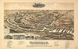
The downtown area was first mapped out and sold in 1798. On January 8, 1801, Virginia officially recognized Waynesborough as a town. It became an incorporated town by 1834.
Some old buildings from this time still stand. The Plumb House is now a museum. The Coiner-Quesenbury House, built in 1806, was likely the first brick house in town. It's still on Main Street.
The town grew slowly at first. In 1810, about 250 people lived there. By 1860, the population was 457. Waynesboro was a popular stop because it was on Three Notch'd Road. This road connected Staunton in the west with Charlottesville and Richmond in the east.
Waynesboro During the Civil War
On March 2, 1865, Waynesboro was the site of the last battle for Confederate General Jubal A. Early in the Civil War. The Battle of Waynesboro was very short, lasting only twenty minutes. It was a big win for Union General George Armstrong Custer. This battle was a final blow to the Confederate Army in the Shenandoah Valley.
Many buildings from this time still show damage from the battle. Soldiers who died in nearby battles were buried in Ridgeview Cemetery. The Waynesboro Confederate Monument there lists their names.
The "Iron Cross" and Basic City
After the war, Waynesboro became a key spot for two important railroad lines. An east-to-west track (the Chesapeake and Ohio Railway) and a north-south track (the Shenandoah Valley Railroad) met here. This meeting point was called the "Iron Cross." The easy transportation from the Iron Cross led to hopes for lots of new businesses.
In 1890, land east of Waynesboro was sold off quickly. This area became the Town of Basic City. It had an opera house, a wide street called Commerce Avenue, and a fancy hotel. Waynesboro and Basic City became friendly rivals, each trying to grow more than the other. The population of the area grew by 150% in just one year.
A big financial crisis in 1896 stopped the growth in Basic City. Plans for more hotels and factories were canceled. Today, the former Basic City area is mostly homes for people with lower incomes.
Becoming an Independent City
Waynesboro continued to grow steadily. Around 1900-1920, many large houses were built in the "Tree Streets" neighborhood. Streets there were named after trees, like Oak Avenue.
In 1923, Waynesboro and Basic City joined together. They were first called Waynesboro-Basic. Later, the name was shortened to Waynesboro. Basic City became one of the "lost towns of Virginia."
Since 1924, Waynesboro has added more land from Augusta County. In 1948, it officially became an independent city.
Geography and Climate
Waynesboro is located at 38°4′11″N 78°53′40″W / 38.06972°N 78.89444°W. It is about 1,305 feet above sea level. The city's elevation ranges from 1,050 feet to 1,800 feet.
The city covers about 15.2 square miles. Most of this is land (15.0 square miles), and a small part is water (0.2 square miles). Waynesboro is in the Shenandoah Valley. The South River, which flows into the Shenandoah River, runs through the city.
What is the Climate Like in Waynesboro?
| Climate data for WAYNESBORO WTP, VA, 1991-2020 normals | |||||||||||||
|---|---|---|---|---|---|---|---|---|---|---|---|---|---|
| Month | Jan | Feb | Mar | Apr | May | Jun | Jul | Aug | Sep | Oct | Nov | Dec | Year |
| Mean daily maximum °F (°C) | 44.2 (6.8) |
47.6 (8.7) |
55.4 (13.0) |
66.3 (19.1) |
74.2 (23.4) |
82.1 (27.8) |
85.7 (29.8) |
84.6 (29.2) |
77.5 (25.3) |
67.7 (19.8) |
56.4 (13.6) |
47.1 (8.4) |
65.7 (18.7) |
| Daily mean °F (°C) | 33.8 (1.0) |
36.2 (2.3) |
43.4 (6.3) |
53.0 (11.7) |
62.1 (16.7) |
70.4 (21.3) |
74.5 (23.6) |
73.0 (22.8) |
66.0 (18.9) |
55.1 (12.8) |
44.5 (6.9) |
37.0 (2.8) |
54.1 (12.3) |
| Mean daily minimum °F (°C) | 23.4 (−4.8) |
24.9 (−3.9) |
31.3 (−0.4) |
39.8 (4.3) |
50.0 (10.0) |
58.6 (14.8) |
63.3 (17.4) |
61.4 (16.3) |
54.5 (12.5) |
42.6 (5.9) |
32.7 (0.4) |
26.8 (−2.9) |
42.4 (5.8) |
| Average precipitation inches (mm) | 3.16 (80) |
2.80 (71) |
4.11 (104) |
3.94 (100) |
3.59 (91) |
4.47 (114) |
3.68 (93) |
3.69 (94) |
5.46 (139) |
3.41 (87) |
4.03 (102) |
2.99 (76) |
45.33 (1,151) |
| Average precipitation days (≥ 0.01 in) | 8.3 | 7.4 | 8.5 | 10.3 | 11.8 | 10.6 | 10.9 | 10.8 | 8.5 | 8.6 | 7.4 | 8.6 | 111.7 |
| Source: NOAA | |||||||||||||
People of Waynesboro
| Historical population | |||
|---|---|---|---|
| Census | Pop. | %± | |
| 1860 | 457 | — | |
| 1870 | 536 | 17.3% | |
| 1880 | 484 | −9.7% | |
| 1890 | 646 | 33.5% | |
| 1900 | 856 | 32.5% | |
| 1910 | 1,389 | 62.3% | |
| 1920 | 1,594 | 14.8% | |
| 1930 | 6,226 | 290.6% | |
| 1940 | 7,373 | 18.4% | |
| 1950 | 12,357 | 67.6% | |
| 1960 | 15,694 | 27.0% | |
| 1970 | 16,707 | 6.5% | |
| 1980 | 15,329 | −8.2% | |
| 1990 | 18,549 | 21.0% | |
| 2000 | 19,520 | 5.2% | |
| 2010 | 21,006 | 7.6% | |
| 2020 | 22,196 | 5.7% | |
| U.S. Decennial Census 1790-1960 1900-1990 1990-2000 2010 2020 |
|||
What is the Population of Waynesboro?
In 2020, Waynesboro had 22,196 people. The city has a mix of different groups. Most people are White, but there are also many Black or African American residents. Other groups include Asian, Native American, and people of mixed races. About 8.76% of the population is Hispanic or Latino.
In 2010, there were 8,903 households in Waynesboro. About 27.1% of these households had children under 18. The average household had 2.34 people. The median age in the city was 38.8 years old.
Economy and Jobs
Waynesboro has had several important employers over the years. A large DuPont plant was a major employer. This plant had the Benger Laboratory, where spandex (known as Lycra) was invented. Another big employer was a textile mill called Wayn-Tex.
The DuPont plant was later sold to Koch Industries and then to a Chinese company called Shandong Ruyi Group. It is now known as The Lycra Company. A General Electric factory also provided many jobs, making relays and later computer printers.
nTelos, a company that provided wireless and phone services, used to have its main office in Waynesboro. Today, tourism, making products, and retail stores are still very important for Waynesboro's economy.
Arts and Culture
Waynesboro has been a filming location for movies like Toy Soldiers (1991) and Evan Almighty (2007). The city has also been mentioned on the TV show The Waltons.
Famous Buildings and Architecture
Near Waynesboro is Swannanoa palace. This beautiful mansion was added to the National Register of Historic Places in 1969.
Sports and Recreation
Waynesboro is home to the Generals, a baseball team in the Valley Baseball League.
Parks and Outdoor Fun
The Blue Ridge Parkway, Skyline Drive, and the Appalachian Trail are all very close to Waynesboro (less than 5 miles away). You can also visit the Blue Ridge Tunnel nearby. This historic tunnel opened as a park in 2021.
Education in Waynesboro
The Waynesboro City Public Schools system serves the area. It includes Waynesboro High School. Waynesboro is also home to Fishburne Military School. This is a private military boarding school for boys in grades 8 through 12.
Transportation
How Do People Travel in Waynesboro?
Waynesboro has two freight rail lines, owned by Norfolk Southern and CSX. These lines cross at "The Iron Cross," which is a historic symbol of the city's growth.
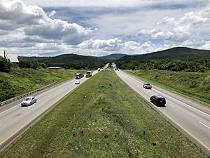
The main highway through Waynesboro is Interstate 64. This highway runs east to west across Virginia. Just west of Waynesboro, I-64 connects with Interstate 81, a major north-south highway. Other highways serving Waynesboro include U.S. Route 250, U.S. Route 340, and Virginia State Route 254.
Media
Waynesboro's local newspaper is The News Virginian.
Notable People from Waynesboro
Many interesting people have come from Waynesboro:
- Cory Alexander – A professional basketball player and sports announcer.
- Ann Bedsole – A politician and businesswoman.
- Shonn Bell – A professional football player.
- Kenny Brooks – A head coach for a women's basketball team.
- Ronnie R. Campbell – A politician in the Virginia House of Delegates.
- Mark Cline – An American artist and entertainer.
- Lew DeWitt – A singer and songwriter, part of The Statler Brothers band.
- Earl Hamner Jr. – A famous television writer and producer.
- Reggie Harris – A professional baseball player.
- Elizabeth Massie – An American horror author.
- P. Buckley Moss – A well-known artist.
- William Henry Sheppard – A Presbyterian missionary to Africa.
See also
 In Spanish: Waynesboro (Virginia) para niños
 | Bessie Coleman |
 | Spann Watson |
 | Jill E. Brown |
 | Sherman W. White |


