
Richland Balsam facts for kids
Quick facts for kids Richland Balsam |
|
|---|---|

Richland Balsam viewed from the Steestachee Bald Overlook
|
|
| Highest point | |
| Elevation | 6,410 ft (1,950 m) |
| Prominence | 3,010 ft (920 m) |
| Geography | |
| Location | Haywood / Jackson counties, North Carolina, U.S. |
| Parent range | Great Balsam Mountains |
| Topo map | USGS Sam Knob |
| Climbing | |
| Easiest route | short hiking trail |
Richland Balsam is a tall mountain in North Carolina, USA. It is part of the Great Balsam Mountains. This mountain is special because it is the highest point in its range.
Richland Balsam rises to about 6,410 feet (1,954 meters) high. This makes it one of the tallest mountains in the entire Appalachian range. The famous Blue Ridge Parkway also crosses Richland Balsam's side. This spot is the highest point on the parkway, reaching 6,053 feet (1,845 meters). The border between Jackson County and Haywood County crosses the very top of the mountain.
A Special Forest
The higher parts of Richland Balsam have a very special type of forest. It is called a Southern Appalachian spruce-fir forest. This kind of forest is rare, with only ten such areas in the Southern Appalachian mountains.
This unique forest has two main types of trees. They are the red spruce and the Fraser fir. People sometimes call them "he-balsam" and "she-balsam." Sadly, in recent years, tiny insects called balsam woolly adelgid have harmed many Fraser fir trees.
Spruce-fir forests grow in the highest, coldest parts of the Southern Appalachians. The weather there is too harsh for other types of trees. These forests look more like those found in Canada or the northern United States.
Protecting the Mountain
Most of Richland Balsam is protected land. The eastern side is part of the Pisgah National Forest. The western side is mostly part of the Nantahala National Forest. These national forests help keep the mountain's natural beauty safe.
The National Park Service also looks after the area where the Blue Ridge Parkway crosses the mountain. There is a parking lot and a viewpoint at the top of Richland Balsam. This spot marks the highest point on the parkway. A short walking trail connects the parking lot to the mountain's summit. This trail helps visitors explore and learn about the area.
Images for kids
-
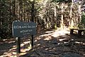
Sign incorrectly marking summit along the hiking trail

