
Jackson County, North Carolina facts for kids
Quick facts for kids
Jackson County
|
|||
|---|---|---|---|

Jackson County Courthouse in Sylva
|
|||
|
|||

Location within the U.S. state of North Carolina
|
|||
 North Carolina's location within the U.S. |
|||
| Country | |||
| State | |||
| Founded | 1851 | ||
| Named for | Andrew Jackson | ||
| Seat | Sylva | ||
| Largest community | Cullowhee | ||
| Area | |||
| • Total | 494.88 sq mi (1,281.7 km2) | ||
| • Land | 491.11 sq mi (1,272.0 km2) | ||
| • Water | 3.77 sq mi (9.8 km2) 0.76% | ||
| Population
(2020)
|
|||
| • Total | 43,109 | ||
| • Estimate
(2023)
|
44,574 |
||
| • Density | 87.1100/sq mi (33.6334/km2) | ||
| Time zone | UTC−5 (Eastern) | ||
| • Summer (DST) | UTC−4 (EDT) | ||
| Congressional district | 11th | ||


Jackson County is a county in the western part of North Carolina. In 2020, about 43,109 people lived here. The main town, or county seat, is Sylva. It became the county seat in 1913, taking over from Webster.
Cullowhee is home to Western Carolina University (WCU). This university is very important to the area. It has over 12,000 students, which is almost double the number of people who permanently live in Cullowhee!
Many people in Jackson County are Cherokee. More than 10 out of every 100 people identify as Native American. The Eastern Band of Cherokee Indians is a federally recognized tribe. Their home, called Qualla Boundary, is partly in Jackson County and partly in nearby Swain County. This is the only federally recognized Native American tribe in North Carolina.
Contents
A Look Back: How Jackson County Began
This area was originally the homeland of the Cherokee Nation. Long ago, towns like Cullowhee grew along the Tuckasegee River. These towns often had large earth mounds built by ancient people. For example, Cullowhee Mound was built around 1000 CE. Archeologists have found signs of people living here since 3000 BCE!
Most Cherokee people were forced to leave their lands in the late 1830s. They were moved to what is now Oklahoma. However, hundreds of Cherokee stayed in Western North Carolina. Their families are now part of the Eastern Band of Cherokee Indians. This tribe is based on the Qualla Boundary.
From the 1800s to Today
More European-American settlers slowly moved into this mountainous area. Jackson County was officially created in 1851. It was formed from parts of Haywood and Macon counties. The county was named after Andrew Jackson, who was President from 1829 to 1837.
Over the years, parts of Jackson County were used to create other counties. For example, Transylvania County was formed in 1861. Swain County was formed in 1871. In 1913, Sylva became the new county seat.
In the 1880s, people started mining for kaolin here. Kaolin is a special clay used to make porcelain. A man named Charles Joseph Harris moved to the area around 1888. He became very important to the county's growth. He started his own mining and lumber companies. His businesses helped the region develop into the 20th century.
Exploring Jackson County's Geography
Jackson County covers about 495 square miles. Most of this is land, with a small part being water. The Tuckasegee River flows right through the county.
Special Natural Areas
Jackson County is home to parts of several beautiful protected areas:
- Blue Ridge Parkway
- Ellicott Rock Wilderness
- Judaculla Rock
- Nantahala National Forest
- Qualla Boundary
- Waterrock Knob
Rivers and Lakes
Many rivers and lakes are found in Jackson County, including:
- Bear Creek Lake
- Chattooga River
- Lake Glenville
- Tuckasegee River
- Whitewater River
Neighboring Counties
Jackson County shares borders with these counties:
- Haywood County (northeast)
- Transylvania County (east)
- Oconee County, South Carolina (south)
- Macon County (west)
- Swain County (northwest)
Who Lives in Jackson County?
| Historical population | |||
|---|---|---|---|
| Census | Pop. | %± | |
| 1860 | 5,515 | — | |
| 1870 | 6,683 | 21.2% | |
| 1880 | 7,343 | 9.9% | |
| 1890 | 9,512 | 29.5% | |
| 1900 | 11,853 | 24.6% | |
| 1910 | 12,998 | 9.7% | |
| 1920 | 13,396 | 3.1% | |
| 1930 | 17,519 | 30.8% | |
| 1940 | 19,366 | 10.5% | |
| 1950 | 19,261 | −0.5% | |
| 1960 | 17,780 | −7.7% | |
| 1970 | 21,593 | 21.4% | |
| 1980 | 25,811 | 19.5% | |
| 1990 | 26,846 | 4.0% | |
| 2000 | 33,121 | 23.4% | |
| 2010 | 40,271 | 21.6% | |
| 2020 | 43,109 | 7.0% | |
| 2023 (est.) | 44,574 | 10.7% | |
| U.S. Decennial Census 1790–1960 1900–1990 1990–2000 2010 2020 |
|||
In 2020, there were 43,109 people living in Jackson County. The county is home to many different groups of people.
About 76% of the people are White. About 9% are Native American, mostly Cherokee. Other groups include Black or African American, Asian, and people of mixed races. About 7.6% of the population is Hispanic or Latino.
In 2000, the average age in the county was 36 years old. About 19% of the people were under 18. Many people also live alone or in married couples.
Getting Around Jackson County
Main Roads
Several important highways run through Jackson County:
 US 19
US 19 US 23
US 23 US 64
US 64 US 74
US 74 US 441
 NC 107
The Great Smoky Mountains Expressway is a major road that goes across the northern part of the county. It connects Sylva to other towns like Waynesville and Cherokee. North Carolina State Highway 107 links Sylva and Western Carolina University to Cashiers in the south.
Airport
The Jackson County Airport is located near Cullowhee. It helps people travel in and out of the county by air.
Railroads
A train line called the Murphy Branch runs through Jackson County. It connects the county by rail to other parts of the country. In Sylva, this line connects with the Great Smoky Mountains Railroad. This railroad offers scenic train rides for tourists.
Learning in Jackson County
Jackson County Public Schools serves most of the county. However, students on the Qualla Boundary (Cherokee Reservation) go to Cherokee Central Schools.
The county is also proud to be home to Western Carolina University in Cullowhee. This university brings many students and new ideas to the area.
Communities and Towns

Jackson County has several towns, villages, and communities:
Towns
Village
Census-designated places
These are areas that are like towns but are not officially incorporated:
Other Communities
Townships
Jackson County is divided into fifteen areas called townships. Each township has its own history and features:
- Barker's Creek: This township is named after a creek. It includes communities like Dicks Creek and Wilmont.
- Canada: Known for its tall ridges and narrow valleys, this remote area has four major lakes.
- Caney Fork: Named for a creek, this area is served by Caney Fork Road.
- Cashiers: This township includes the town of Cashiers and other communities like Sapphire. It's known for its rivers and the Eastern Continental Divide.
- Cullowhee: This township is named from a Cherokee word. It's the largest by population and home to Western Carolina University.
- Dillsboro: This township includes the town of Dillsboro. Several major highways meet here.
- Greens Creek: Named for a creek, this township is served by US 441.
- Hamburg: This township was once a large valley that was flooded to create Lake Glenville.
- Mountain: Named for Cullowhee Mountain, this township is where Cullowhee Creek begins.
- Qualla: Most of this township is part of the Qualla Boundary, the home of the Eastern Band of Cherokee Indians. It has a Cherokee language immersion school.
- River: Named for the Tuckasegee River, which forms here. The community of Tuckasegee is located here.
- Savannah: This township is named for Savannah Creek. It includes communities like Pumpkintown.
- Scotts Creek: Named for Scotts Creek, this township includes communities like Balsam and Addie.
- Sylva: This township is named for William D. Sylva and is home to the county seat, Sylva. The Jackson County Courthouse is here.
- Webster: This township was the original geographical center of the county and the county seat until 1913.
Images for kids
-
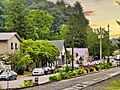
Downtown Dillsboro

See also
 In Spanish: Condado de Jackson (Carolina del Norte) para niños
