Qualla Boundary facts for kids
Quick facts for kids
Qualla Boundary
|
|
|---|---|

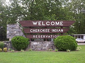
Cherokee Indian Reservation sign
|
|
| Country | |
| State | |
| Counties | Cherokee, Graham, Haywood, Jackson, Swain |
| Established | 1876 |
| Added to Trust | 1924 |
| Named for | Polly |
| Government | Eastern Band of Cherokee Indians |
| Time zone | UTC-5 (Eastern (EST)) |
| • Summer (DST) | UTC-4 (EDT) |
| Area code(s) | 828 |
| GNIS feature ID | 1018039 |
The Qualla Boundary or The Qualla is a special area of land in western North Carolina. It is held in trust by the United States government for the Eastern Band of Cherokee Indians. This means the land is protected for the Cherokee people.
This area is part of the much larger historic Cherokee homeland. This homeland once stretched across parts of Tennessee, South Carolina, Georgia, and Alabama. Today, the biggest part of the Qualla Boundary is in Haywood, Swain, and Jackson counties. The main town there is Cherokee, which is the capital for the Eastern Band of Cherokee Indians. There are also smaller parts of the Qualla Boundary in Graham and Cherokee counties.
The tribe bought this land in the 1870s. Later, the government placed it under a special trust to protect it. This is different from a reservation created by the government. Members of the Eastern Band of Cherokee Indians can buy, own, and sell land within the Qualla Boundary.
Contents
What's in a Name?
The name "Qualla" comes from the Cherokee word kwalli. This word means "old woman." It was named this because an old Cherokee woman named Polly used to live in the area.
Where is the Qualla Boundary?
The Qualla Boundary is located at 35°30′N 83°16′W / 35.500°N 83.267°W.
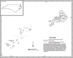
The main part of the Qualla Boundary is in eastern Swain and northern Jackson counties. It is just south of the Great Smoky Mountains National Park. A small part of this land also goes into Haywood County. There are also smaller, separate pieces of land to the southwest. These are in the Marble, Hiwassee, and Hanging Dog areas of Cherokee County, North Carolina. Another part is in the Snowbird community in Graham County, North Carolina. All these areas together cover about 213.934 square kilometers (82.6 square miles). In 2000, about 8,092 people lived there.
A Look at History
The Cherokee people and their ancestors have lived in this area for many centuries. They were here long before Europeans arrived. When European settlers moved west, they sometimes had conflicts with the Cherokee. The Cherokee's land used to reach into what is now Tennessee and northern Georgia. After the late 1700s, many Cherokee moved further south. They went along the Tennessee River, into Georgia, and west into Alabama. They built new towns there.
In the late 1830s, the U.S. government forced many Cherokee to leave their homes. This was due to a law called the 1830 Indian Removal Act. They were moved to Indian Territory, which is now Oklahoma.
During the winter of 1838 and spring of 1839, about 11,000 Cherokee were moved from North Carolina. This sad journey is known as the Trail of Tears. Some Cherokee managed to hide in the Great Smoky Mountains and avoid being moved. Others were allowed to stay on their land because of earlier agreements. But most Cherokee people were forced to leave. This is when the fight for the land that became the Qualla Boundary really began.
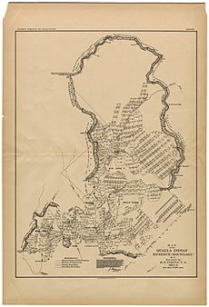
The Qualla Boundary was first officially measured in 1876. This was done by M. S. Temple for the United States Land Office. A map called the Map of the Qualla Indian Reserve was then published.
The Qualla Boundary is a land trust overseen by the United States Bureau of Indian Affairs. It is a small part of the large historical homeland of the Cherokee people. This land was once part of the Cherokee Nation before the forced removals in the 1830s.
A man named William Holland Thomas lived and worked with the Cherokee people for much of his life. He knew their traditions and language well. He was also good friends with some tribe members. The Cherokee respected Thomas. He had studied law and was adopted into the tribe. He was even named as the next chief by the tribe's leader. He is the only European American to have been a chief in Cherokee history.
Thomas bought land around the Oconaluftee River for the tribe. This land was about 50,000 acres. It is still a big part of the Qualla Boundary today. In 1870, the Cherokee formed a group to buy and own more land. The Cherokee who were able to stay in North Carolina were seen as a separate group from the Cherokee Nation in Oklahoma.
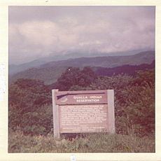
A sign from the United States Department of the Interior about the "Qualla Indian Reservation" says:
The Cherokee homeland once reached far beyond the mountains. But white settlers, with broken agreements, caused trouble for the Indians. This led to their forced move to an Oklahoma reservation. A few escaped and hid in the Great Smoky Mountains. They eventually formed the Eastern Band that now lives on the Qualla Reservation in the valley below.
How the Community is Run
The Cherokee community works like many towns. They have their own schools, police, and rescue services. They also have their own hospital and a gaming casino called Harrah's Cherokee. They have opened a second casino location in Murphy, North Carolina. The Tribe has had its own court system since 1987.
Tribal police are in charge of law enforcement on Indian lands. The FBI and other federal groups handle certain major federal crimes. State police and other state officers can help tribal police if needed. They can also be given special roles to help with federal investigations. If someone who is not a tribe member commits a crime in the Qualla Boundary, their case goes to local county courts.
Community Areas
The Qualla Boundary is divided into seven communities. These are like small towns or districts.
| Community | Counties it is in |
|---|---|
| Big Cove | Swain County |
| Birdtown | Jackson County, Swain County |
| Cherokee County | Cherokee County |
| Painttown | Jackson County |
| Snowbird | Graham County |
| Wolftown | Haywood County, Jackson County, Swain County |
| Yellowhill | Swain County |
There are no official cities or towns within the Qualla Boundary. Instead, each community chooses two people to represent them on the EBCI tribal council. However, Cherokee County and Snowbird share two representatives. The community of Cherokee covers most of Painttown and Yellowhill, and a small part of Wolftown.
Learning and Education
From 1890 to 1954, the U.S. Indian Service ran the Cherokee Boarding Schools. These were in Cherokee. Later, smaller elementary schools opened in Big Cove, Soco, Birdtown, and Snowbird. In 1962, all these elementary schools joined together to form Central Elementary School in Cherokee. In 1975, Cherokee High School opened for grades seven through twelve.
On August 1, 1990, Cherokee Central Schools became a school district run by the tribe. Students from Big Cove, Birdtown, Painttown, Wolftown, and Yellowhill communities attend these schools. In 1996, the school district started the Kituwah curriculum. This program teaches students from kindergarten to sixth grade using the Cherokee language. Before this, the Cherokee language was not allowed when the schools were run by the Bureau of Indian Affairs.
In 2004, the EBCI started the New Kituwah Academy. This is a private school that teaches in both Cherokee and English. It is an immersion school for Cherokee students from kindergarten to sixth grade. It is located in the Yellowhill community.
Western Carolina University Cherokee Center
This center started in 1975. It works with the EBCI to connect Western Carolina University with people in the Qualla Boundary. It helps students with applying to college, getting transcripts, finding scholarships, and internships. It also offers college-level courses. The Cherokee Center has a Director and an advisory board with members from both the EBCI and Western Carolina University.
Qualla Boundary in Movies and TV
In the mid-1950s, parts of Disney's five-part TV series, Davy Crockett, were filmed here. Fess Parker starred in the show.
 | Dorothy Vaughan |
 | Charles Henry Turner |
 | Hildrus Poindexter |
 | Henry Cecil McBay |


