
Great Smoky Mountains National Park facts for kids
Quick facts for kids Great Smoky Mountains National Park |
|
|---|---|
|
IUCN Category II (National Park)
|
|

Great Smoky Mountains National Park
Location in Tennessee

Great Smoky Mountains National Park
Location in the United States
|
|
| Location | Swain and Haywood counties, North Carolina; Sevier, Blount, and Cocke counties, Tennessee, United States |
| Nearest city | Cherokee, North Carolina, Bryson City, North Carolina, Townsend, Tennessee, Cosby, Tennessee and Gatlinburg, Tennessee |
| Area | 522,419 acres (2,114.15 km2) |
| Established | June 15, 1934 |
| Visitors | 12,191,834 (in 2024) |
| Governing body | National Park Service |
}} The Great Smoky Mountains National Park is a special natural area in the southeastern United States. It sits right on top of the Great Smoky Mountains, which are part of the bigger Appalachian Mountains. This area is also a temperate rainforest, meaning it gets a lot of rain! You'll find some of the tallest mountains in eastern North America here, like Kuwohi, Mount Guyot, and Mount Le Conte. The border between Tennessee and North Carolina cuts right through the middle of the park. The famous Appalachian Trail also winds its way through the park. With more than 12 million visitors in 2024, it's the most visited national park in the entire United States!
The park covers a huge area of about 522,419 acres (that's over 800 square miles!), making it one of the biggest protected places in the eastern U.S. You can enter the park from places like Gatlinburg, Tennessee, Cherokee, North Carolina, and Townsend, Tennessee. The main road through the park is U.S. Highway 441, also known as Newfound Gap Road. People from all over the world know this park for its amazing mountains, beautiful waterfalls, many different kinds of plants and animals (called biodiversity), and lush forests. It also protects many old buildings that show how early settlers lived here long ago.
The U.S. Congress officially created the park on June 15, 1934. President Franklin D. Roosevelt dedicated it in 1940. This park was special because it was the first national park where the government helped pay for the land. Before this, other parks were bought with money from states or private groups. It's so important that UNESCO named it a World Heritage Site in 1983 and an International Biosphere Reserve in 1988.
The park is a huge draw for tourists, bringing many visitors to nearby towns like those in Sevier County, Tennessee. Popular attractions like Dollywood and Ober Gatlinburg are close by. This tourism helps the local economy a lot, bringing in billions of dollars each year.
Contents
- Exploring the Park's Geography
- Understanding the Park's Geology
- The Park's Environment and Climate
- Amazing Plants and Animals: Biodiversity in the Smokies
- Fun Things to Do and See in the Park
- A Look at the Park's History
- See also
Exploring the Park's Geography
The Great Smoky Mountains National Park covers about 522,419 acres. It's split almost equally between Tennessee and North Carolina. You'll find parts of it in Blount, Sevier, and Cocke Counties in Tennessee. In North Carolina, it's in Swain and Haywood Counties. To the south, the park touches an Indian reservation. This is where the Eastern Band of Cherokee Indians live. They are descendants of Cherokee people who stayed in their homeland, even when many others were forced to move to Oklahoma long ago.
Gatlinburg, Tennessee is just north of the park. Other towns nearby include Townsend, Tennessee, Bryson City, and Maggie Valley. The park is also surrounded by other protected lands, like the Cherokee National Forest and the Nantahala National Forest.
Towering Mountains of the Smokies
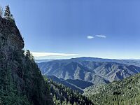
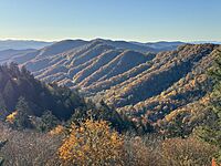
The park protects most of the Great Smoky Mountains. These mountains are part of the larger Blue Ridge Mountains and the even bigger Appalachian Mountains. The mountains stretch from east to west. They are surrounded by other mountain ranges like the Bald Mountains and the Plott Balsams. The park also includes some smaller hills, called foothills, to the north.
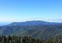
As you go from west to east, the mountains get wider. Most of the tallest peaks are in the eastern part. The land here goes from about 875 feet high to 6,643 feet high at the top of Kuwohi. Kuwohi is the highest mountain in Tennessee and the third-highest mountain east of the Mississippi River. The park has 16 mountains that are over 6,000 feet tall!
Mount Guyot is the second tallest at 6,621 feet. Mount Le Conte is 6,593 feet high. It rises an amazing 5,301 feet from its base, making it the tallest mountain east of the Rocky Mountains when measured from bottom to top!
Between the mountains, you'll find deep valleys, some called 'coves'. The biggest and most famous is Cades Cove. It's a wide, flat area between the main mountains and the foothills. Other important valleys include The Sugarlands, Greenbrier, Oconaluftee, and Cataloochee. These valleys are easy to reach and are great places to start exploring the park.
-
Kuwohi is the highest mountain in the national park at 6,643 feet (2,025 m).
-
Mount Le Conte is the tallest mountain in eastern North America, measured from base to summit.
-
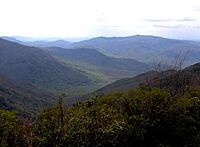
The Sugarlands is one of several prominent valleys within the range.
-
View of the mountains from Newfound Gap.


Streams and Waterfalls to Discover
_-_Flickr_-_mrksteele04.jpg)
The park is part of the Tennessee Valley and has about 2,900 miles of streams flowing through it. The Little Tennessee River flows along the park's southwestern edge. Several dams, like Fontana Dam, create lakes along this border. The Pigeon River cuts through a deep gorge near the park's eastern side.
Many smaller rivers start in the park, such as the Little Pigeon River, the Oconaluftee River, and the Little River. Other important streams include Hazel Creek and Roaring Fork. The park boasts over 100 amazing waterfalls! The tallest is Ramsey Cascades, which drops 100 feet. Rainbow Falls is the tallest single-drop waterfall, falling 80 feet. Other popular waterfalls include Grotto Falls, Laurel Falls, and Abrams Falls.
Historic Areas and Old Buildings

The park service takes care of many historic places. There are four historic districts and one archaeological district inside the park. Many old buildings, like those at the Mountain Farm Museum in Oconaluftee, are also preserved. The Mingus Mill and a cabin in Greenbrier are also important historical sites.
- Historic districts
- Cades Cove Historic District
- Elkmont Historic District
- Oconaluftee Archaeological District
- Noah Ogle Place
- Roaring Fork Historic District
- Individual listings

- Alex Cole Cabin
- Kuwohi Observation Tower
- Hall Cabin (in Hazel Creek area)
- John Messer Barn
- John Ownby Cabin
- Oconaluftee Baptist Church (also called Smokemont Baptist Church)
- Tyson McCarter Place
- Mayna Treanor Avent Studio
- Little Greenbrier School
- Walker Sisters Place
Understanding the Park's Geology

Most of the rocks in the Great Smoky Mountains National Park are very old, from a time called the late Precambrian. These rocks, part of the Ocoee Supergroup, are changed types of sandstone, slate, and other rocks. Even older rocks, from the early Precambrian, are also found. These are mostly granite and other changed rocks, and they are the oldest rocks in the park.
You can find younger sedimentary rocks in the foothills and in places like Cades Cove. Cades Cove is special because older sandstone rocks surround a valley floor made of younger limestone rocks. The very oldest rocks here, called Precambrian gneiss and schists, formed over a billion years ago from ocean sediments and volcanic rock. Later, in the late Precambrian, more rocks formed as land eroded and settled on the ocean floor.
Millions of years ago, during the Paleozoic era, huge layers of ocean sediment created more rocks. Then, the North American and African continents slowly crashed into each other. This giant collision pushed up the land, forming the Appalachian Mountains we see today! Over time, softer rocks wore away, revealing the older Ocoee Supergroup rocks again.
About 20,000 years ago, during the Ice Age, glaciers moved south. While they didn't reach the Smokies, the weather became much colder and wetter. Trees couldn't grow on the highest peaks, and the valleys had spruce-fir forests. The constant freezing and thawing during this time created the large piles of rocks you can still see at the bottom of some mountain slopes.
The Park's Environment and Climate
Climate and Weather Patterns
The park has different types of climates, from warm and humid to cooler, like you might find in Canada. As you climb the mountains, the temperature drops, just like traveling north!
| Climate data for Kuwohi Visitor Center, North Carolina (1981–2010 averages). Elevation 6,348 feet (1,935 m). | |||||||||||||
|---|---|---|---|---|---|---|---|---|---|---|---|---|---|
| Month | Jan | Feb | Mar | Apr | May | Jun | Jul | Aug | Sep | Oct | Nov | Dec | Year |
| Mean daily maximum °F (°C) | 40.5 (4.7) |
43.9 (6.6) |
51.5 (10.8) |
61.5 (16.4) |
67.5 (19.7) |
73.3 (22.9) |
75.6 (24.2) |
75.4 (24.1) |
71.4 (21.9) |
63.8 (17.7) |
52.5 (11.4) |
43.7 (6.5) |
60.1 (15.6) |
| Daily mean °F (°C) | 31.2 (−0.4) |
34.1 (1.2) |
40.5 (4.7) |
49.2 (9.6) |
56.4 (13.6) |
63.2 (17.3) |
66.2 (19.0) |
65.7 (18.7) |
60.7 (15.9) |
52.3 (11.3) |
42.3 (5.7) |
34.3 (1.3) |
49.7 (9.8) |
| Mean daily minimum °F (°C) | 21.9 (−5.6) |
24.2 (−4.3) |
29.6 (−1.3) |
36.9 (2.7) |
45.3 (7.4) |
53.1 (11.7) |
56.7 (13.7) |
55.9 (13.3) |
50.0 (10.0) |
40.8 (4.9) |
32.1 (0.1) |
24.9 (−3.9) |
39.4 (4.1) |
| Average precipitation inches (mm) | 7.38 (187) |
6.56 (167) |
6.69 (170) |
5.65 (144) |
6.61 (168) |
6.75 (171) |
7.17 (182) |
5.72 (145) |
6.38 (162) |
4.89 (124) |
7.60 (193) |
6.48 (165) |
77.88 (1,978) |
| Average relative humidity (%) | 71.9 | 72.8 | 68.1 | 64.4 | 76.2 | 82.8 | 83.6 | 85.4 | 82.7 | 74.7 | 72.8 | 76.2 | 76.0 |
| Average dew point °F (°C) | 23.2 (−4.9) |
26.3 (−3.2) |
30.8 (−0.7) |
37.7 (3.2) |
49.0 (9.4) |
57.9 (14.4) |
61.1 (16.2) |
61.2 (16.2) |
55.4 (13.0) |
44.5 (6.9) |
34.2 (1.2) |
27.6 (−2.4) |
42.5 (5.8) |
| Mean monthly sunshine hours | 155.0 | 141.3 | 217.0 | 240.0 | 279.0 | 270.0 | 279.0 | 248.0 | 210.0 | 217.0 | 150.0 | 124.0 | 2,530.3 |
| Mean daily sunshine hours | 5 | 5 | 7 | 8 | 9 | 9 | 9 | 8 | 7 | 7 | 5 | 4 | 7 |
| Mean daily daylight hours | 10.1 | 10.9 | 12.0 | 13.1 | 14.1 | 14.5 | 14.3 | 13.5 | 12.4 | 11.3 | 10.3 | 9.8 | 12.2 |
| Percent possible sunshine | 50 | 46 | 58 | 61 | 64 | 62 | 63 | 59 | 56 | 62 | 49 | 41 | 56 |
| Average ultraviolet index | 3 | 4 | 6 | 8 | 9 | 10 | 10 | 9 | 8 | 5 | 3 | 2 | 6 |
| Source 1: PRISM Climate Group | |||||||||||||
| Source 2: Weather Atlas (sun data) | |||||||||||||
The Smoky Mountains get a lot of rain because of the humid air and how the mountains push the air upwards. The park receives between 50 and 80 inches of rain each year. Higher elevations also get heavy snowfall in winter. Sudden floods can happen after heavy rains.
Temperatures change a lot between the mountain tops and the valleys. For example, Newfound Gap (5,048 feet high) is usually 10-13 degrees Fahrenheit cooler than the valleys (around 1,600 feet high). Strong winds, sometimes reaching 80-100 mph, happen a few times a year, mostly from October to April. These winds can cause damage, like during the big Gatlinburg fire in 2016.
Air Quality and Pollution Control
The park has faced challenges with air pollution due to nearby development. In 2004, it was even called the most polluted national park. However, things have gotten much better! Thanks to the United States Clean Air Act passed in 1970, air quality has significantly improved from 1990 to 2010.
Visibility in the park on hazy days has improved from an average of 9 miles in 1998 to 40 miles in 2018. Reports in 2023 showed big drops in harmful emissions like sulfur dioxide and carbon monoxide. This means cleaner air for everyone to enjoy the beautiful views!
Amazing Plants and Animals: Biodiversity in the Smokies
The Great Smoky Mountains National Park is the most biologically diverse national park in the United States. Scientists know of about 19,000 different kinds of living things here. They think there might be as many as 80,000 to 100,000 more species yet to be discovered! This huge variety of life is helped by the park's rainy and mild climate. No other place of its size in a similar climate has so many different species.
Flora: The Park's Plant Life

Forests cover about 95 percent of the Great Smoky Mountains National Park. In lower areas, you'll find deciduous trees that lose their leaves in the fall. Higher up, there are coniferous trees like the Fraser fir. About 20-25 percent of the forests are old-growth forest, meaning many trees are very old, even from before European settlers arrived. This is one of the largest areas of old-growth forest in North America.
The park has an amazing variety of plants because of its different elevations, lots of rain, and old forests. It's home to over 1,500 species of flowering plants, more than any other national park in North America! This includes 35 kinds of orchids and 58 types of lilies. The park also has 101 native tree species and 114 native shrub species. You can find over 4,000 species of non-flowering plants, 2,700 fungi, and many types of algae and lichens. Plants and animals usually found in the northern U.S. live in the higher, cooler parts of the park. Southern species thrive in the warmer, lower areas.
The forests are usually divided into three main types:
- Cove hardwood forests in the valleys and lower mountain slopes.
- Northern hardwood forests on the higher mountain slopes.
- Spruce-fir or boreal forests at the very highest elevations.
You'll also see "Appalachian balds," which are open areas where trees are missing or sparse. These can be grassy balds or heath balds, covered in shrubs like rhododendron and mountain laurel.
Cove Hardwood Forests

Cove hardwood forests are some of the most diverse forests in North America. Most of these forests in the Smokies are second-growth, meaning they grew back after being cut down. However, about 72,000 acres are still old-growth. These forests are found in valleys below 4,500 feet, where the soil is deep and moist. Albright Grove, along the Maddron Bald Trail, is an old-growth forest with some of the oldest and tallest trees in the area.
Over 130 species of trees grow in these forests. Common trees include yellow birch, basswood, yellow buckeye, and tulip tree. The American chestnut, once a favorite tree, was sadly wiped out by a disease in the early 1900s. The lower layers of these forests have many shrubs and vines, like Eastern redbud, flowering dogwood, and Catawba rhododendron.
Northern Hardwood Forests

The higher parts of the Smokies are cool enough for forests usually found in the northern United States. These northern hardwood forests are the highest broad-leaved forests in the eastern U.S. About 28,600 acres of these are old-growth.
In these forests, you'll mostly find yellow birch and American beech trees. Other trees like white basswood and sugar maple are also present. The plants growing beneath the trees include coneflower, hydrangea, and various grasses and ferns.
A special area is called a "beech gap" or "beech orchard." These are high mountain gaps taken over by beech trees. The trees often look twisted because of strong winds. Scientists are still trying to understand why other trees don't grow in these areas.
Spruce-Fir Forests and Their Life Cycle

The Southern Appalachian spruce-fir forest, also called the "boreal" or "Canadian" forest, is a leftover from the Ice Ages. Back then, the Smokies were too cold for hardwood forests. While temperatures rose and hardwoods returned, the spruce-fir forest survived on the harsh mountain tops, usually above 5,500 feet. About 10,600 acres of this forest are old-growth.
This forest mainly has two types of conifer trees: red spruce and Fraser fir. Fraser firs, which are native to this region, once covered the highest elevations. However, a tiny insect called the balsam woolly adelgid arrived in the 1960s and killed about 90% of the mature firs. Now, red spruce is the main tree in these forests. But, with fewer firs, the red spruce trees are more exposed to wind.
Good news! Recent studies show that Fraser firs are growing back on peaks like Mount Collins and Kuwohi. Some red spruces are believed to be 300 years old and can grow over 100 feet tall. The main difference from northern spruce-fir forests is the thick understory of broad-leaved plants here. These include Catawba rhododendron, mountain ash, and thornless blackberry. The ground is often dark, so shade-loving plants like ferns and over 280 species of mosses thrive.
Montane Alluvial Forests
These forests grow in narrow, rocky floodplains. You can find trees like Tulip trees, Eastern Hemlock, Oaks, Birches, and Rhododendron here. The American Sycamore is also present in these unique areas.
Wildflowers: A Burst of Color

The Great Smoky Mountains National Park has over 1,400 species of flowering plants. Many wildflowers grow in the mountains and valleys. These include bee balm, Solomon's seal, Dutchman's breeches, and various trilliums. You can even find hardy orchids!
There are two native types of rhododendron. The catawba rhododendron has purple flowers in May and June. The rosebay rhododendron has longer leaves and white or light pink blooms in June and July. The orange or red flame azalea blooms around the same time as the catawbas. The mountain laurel blooms in between these two. All these blooms start at lower elevations and move higher up the mountains. In autumn, the opposite happens, with colorful leaves appearing in the valleys while the mountaintops might already have frost.
Fauna: Animals of the Great Smoky Mountains
The Great Smoky Mountains National Park is home to 65 species of mammals, over 240 species of birds, 67 species of fish, 40 species of reptiles, and 43 species of amphibians.
Mammals and Their Reproduction
.jpg)
The American black bear is probably the most famous animal in the park. It has become a symbol of the park's wildlife. The Smokies have the largest black bear population east of the Mississippi River. Most adult black bears weigh between 100 and 300 pounds, but some have been as heavy as 600 pounds! About 1,900 black bears live in the park, though this number can change.

The Smokies are home to 27 species of rodents, including North American beavers, woodchucks, chipmunks, and two types of squirrels and skunks. The endangered northern flying squirrel also lives here. Twelve species of bats, including the endangered Indiana bat, are found in the park. Other mammals include white-tailed deer, whose population grew a lot after the park was created. The bobcat is the only wild cat species left, though people sometimes report seeing cougars. Raccoons are very common in the park. The Virginia opossum, the only marsupial in North America, also lives here.
Coyotes are not native but have moved into the area recently and are now considered a native species. Both red foxes and gray foxes are found in the Smokies. North American river otters were brought back to the park between 1986 and 1994. Elk were also reintroduced in 2001 and 2002. Today, you can see many elk in the Cataloochee area. European wild boars, brought here in the early 1900s, are now a problem because they dig up and destroy plants. The park service has a program to help control their numbers.
Birds and Their Breeding Grounds
.jpg)
The Smokies have many different kinds of birds because of the various forest types. Nearly 120 bird species use the park as a place to breed and raise their young. Many other migratory birds stop here to rest and find food. Birds that like southern hardwood forests, like the red-eyed vireo and wild turkey, live in the lower elevations. Birds that prefer cooler climates, like the raven and black-capped chickadee, are found in the spruce-fir forests.
Ovenbirds and downy woodpeckers live in the drier pine-oak forests. Bald eagles and golden eagles have been seen all over the park. Peregrine falcons are also sometimes spotted. Red-tailed hawks are the most common hawk species. Owl species include the barred owl and eastern screech owl.
Reptiles and Amphibians: The Salamander Capital

The Great Smoky Mountains National Park is famous for having one of the world's most diverse salamander populations. It's even called the "Salamander Capital of the World"! Five of the world's nine salamander families live here, with up to 31 different species. The red-cheeked salamander is found only in the Smokies. The imitator salamander lives only in the Smokies and nearby mountains. Other species include the shovelnose salamander and the eastern red-spotted newt. The hellbender, a giant salamander, lives in fast-flowing streams and can grow up to 29 inches long. The park also has 14 species of frogs and toads, including the American toad and the American bullfrog.

Reptiles in the park include eight species of turtles, nine species of lizards, and 23 species of snakes. Most of these snakes are non-venomous, like various kingsnakes and the black rat snake. The timber rattlesnake and the copperhead are the two venomous snakes found here. Both are pit vipers. The eastern box turtle is the most common turtle and lives mostly on land, but often near water. Important lizards include the eastern fence lizard and green anole. The rarest lizard is the eastern slender glass lizard, which looks like a snake because it has no legs.
Fish in the Park's Waters

The park's streams are home to fish like trout, lamprey, darter, shiner, bass, and minnows. About 1,073 miles of streams in the park support fish. The brook trout is the only trout species native to these mountains. However, rainbow trout and European brown trout were introduced in the early 1900s. These larger trout often outcompete the native brook trout for food and space in lower streams. So, most brook trout today are found in streams above 3,000 feet where the water is cooler.
Four protected fish species – the smoky madtom, yellowfin madtom, spotfin chub, and duskytail darter – also live in the park.
Insects and Their Role in the Ecosystem

More than 9,000 species of insects have been found in the park. The most common groups include butterflies, moths, beetles, flies, wasps, bees, and ants. These insects are super important! They help pollinate plants and break down wood. The firefly Photinus carolinus is special because its synchronized flashing light displays happen in mid-June near Elkmont, Tennessee. This firefly is so popular that many visitors come just to see its amazing light show!
Fun Things to Do and See in the Park
The Great Smoky Mountains National Park is a very popular place to visit. It has been the most visited national park for many years, with over 14.1 million tourists in 2021.
The park has three main entrances: in Gatlinburg, Cherokee, and Townsend. U.S. Route 441 (Newfound Gap Road) is the main road through the park, connecting Cherokee and Gatlinburg. The Gatlinburg entrance is the busiest.
Hiking and Exploring Trails

There are 850 miles of trails and unpaved roads in the park for hiking.
About 71.6 miles of the Appalachian Trail (AT) are located within the park. The AT enters the park near Fontana Dam and follows the crest of the mountains, rarely dropping below 5,000 feet. Kuwohi is the highest point along the entire trail. Other notable peaks on the AT include Thunderhead Mountain and Mount Guyot. There are 12 trail shelters along the Appalachian Trail in the park, mostly used for long backpacking trips.
Mount Le Conte is one of the most visited places in the park. Five trails lead to its summit. The Alum Cave Trail is the most popular, offering beautiful views and natural sights like Alum Cave Bluffs. Hikers can stay overnight at the LeConte Lodge, which has cabins and rooms for rent (except in winter). It's the only private lodging inside the park and the highest inn in the eastern United States.

Sightseeing and Scenic Drives
The most visited spot in the park is Cades Cove. This open valley offers amazing views of the surrounding mountains. Cades Cove has many old buildings, including log cabins, barns, and churches. An 11-mile one-way loop road goes around Cades Cove. You can drive or bike this road to see how people lived in the old days of southern Appalachia. Other historical areas include Roaring Fork, Cataloochee, Elkmont, and the Mountain Farm Museum in Oconaluftee.

U.S. Route 441 (Newfound Gap Road) lets you drive to many trailheads and overlooks, especially Newfound Gap. This spot is 5,048 feet high and is near the center of the park, on the Tennessee/North Carolina state line. President Franklin D. Roosevelt dedicated the national park here in 1940. On clear days, Newfound Gap offers some of the best views you can see from a car in the park. A 45-foot observation tower is located atop Kuwohi. You can reach it by a 1/2-mile trail from a parking area. The tower gives you a 360-degree view of the mountains. On a clear day, you might see up to 100 miles away!
Besides Newfound Gap Road and Cades Cove, there are other scenic drives. Lakeview Drive, along Fontana Lake, is a beautiful road that was never finished. The Foothills Parkway also offers great views of the mountains and the Tennessee Valley. The southern end of the Blue Ridge Parkway is near the park in Cherokee.

Other Fun Activities
After hiking and sightseeing, fishing (especially fly fishing) is the most popular activity. The park's waters are known for healthy trout. The brook trout is native, while brown and rainbow trout were introduced. There are strict rules for fishing. Horseback riding, bicycling (you can rent bikes in Cades Cove), and water tubing are also popular. Many roads in the park are favorites for motorists and car enthusiasts. A section of U.S. Route 129, known as the "Tail of the Dragon," is famous for its many curves and is popular with motorcyclists and sports car fans.
You can camp in designated backcountry campsites throughout the park. You need a permit, which you can get at ranger stations or online. Reservations are required for all shelters and backcountry campsites. You can usually stay one night in shelters or three nights in campsites.
From late May to early June, the Elkmont area of the park hosts a special event: the synchronized flashing of fireflies (Photinus carolinus). These are the only fireflies in America that can flash their lights together at the same time!
A Look at the Park's History
Early People and the Cherokee Nation
Native Americans likely hunted in the Great Smoky Mountains for 14,000 years. Tools and other items from ancient times (8000–1000 B.C.) have been found in the park. Evidence of early farming and 2,000-year-old pottery from later periods (1000 B.C. - 1000 A.D.) also exist.
As farming became more important, Native Americans moved from the mountains to fertile river valleys. Large villages from the Mississippian period (900–1600 A.D.) were found along the Little Tennessee River. Explorers like Hernando de Soto in 1540 and Juan Pardo in 1567 passed through the area, visiting some of these villages.
In the late 1600s, the Cherokee people began moving into what is now eastern Tennessee and western North Carolina. By the time European settlers arrived, the Cherokee controlled much of this region, with the Great Smoky Mountains at the heart of their territory. They called the mountains Shaconage, meaning "place of blue smoke." Cherokee legends tell of magical places and creatures hidden deep within the range. Important Cherokee names for places in the Smokies include Tsitsuyi (rabbit place) for Gregory Bald and Kuwohi (mulberry place) for the highest peak.
Most Cherokee towns were in the river valleys around the Smokies. The village of Oconaluftee, near the modern Oconaluftee Visitor Center, was the only known permanent Cherokee village inside what is now the national park. Some seasonal settlements were in Cades Cove and the Hazel Creek valley.
European Settlers and the Cherokee Removal
European explorers and settlers started arriving in the mid-1700s. This led to conflicts with the Cherokee, who owned the land. During the American Revolutionary War, the Cherokee sided with the British, and American forces attacked Cherokee territory. By 1805, the Cherokee had given control of the Smokies to the U.S. government.
Sadly, in 1838, most of the Cherokee tribe was forced to move west on the Trail of Tears. However, a small group, thanks to William Holland Thomas, managed to keep their land on the Qualla Boundary. Their descendants make up the Eastern Band of Cherokee Indians today.
In the 1780s, frontier outposts were built around the Smokies. Permanent settlers began arriving in the 1790s. John Mingus settled on the Oconaluftee in 1795. The Whaley brothers were the first settlers in the Greenbrier section in 1801. In 1802, William Ogle prepared logs for a cabin in White Oak Flats. His wife, Martha Jane Huskey, and her family later became the first permanent settlers in what is now Gatlinburg. Their families spread into the Sugarlands and Roaring Fork areas.
Cades Cove was settled by families who bought land from William "Fighting Billy" Tipton. The first settlers, John and Lucretia Oliver, arrived in 1818. More families followed, and the Cades Cove Baptist Church was founded in 1827. The Cataloochee area was first settled by the Caldwell family in 1834.
Life in the early 1800s in the Smokies involved subsistence agriculture, where families grew most of their own food. Farms were typically about 50 acres. Early settlers lived in log cabins, which later became more elaborate log houses. Most farms had a barn, a springhouse for cooling food, a smokehouse for curing meat, and a chicken coop. Religion was very important, and community life often centered around churches.
The American Civil War in the Mountains
During the American Civil War (1861-1865), both Tennessee and North Carolina joined the Confederacy. However, many people in the Great Smoky Mountains supported the Union. Generally, communities on the Tennessee side supported the Union, while those on the North Carolina side supported the Confederates. This was because slavery was not common in these mountain regions.
No major battles happened in the Smokies, but small fights were frequent. Cherokee chief William Holland Thomas formed a Confederate group, including Cherokee soldiers. They occupied Gatlinburg for several months in 1862. People from Union-supporting Cades Cove and Confederate-supporting Hazel Creek often crossed the mountains to steal livestock from each other.
Logging and the Birth of the Park

For a long time, logging in the Great Smoky Mountains was difficult because the forests were hard to reach. But in the late 1800s, new technologies like logging railroads and band saws made large-scale logging possible. The biggest logging company was the Little River Lumber Company, which operated from 1901 to 1939. They built the Little River Railroad and created company towns like Townsend and Elkmont.

Other companies, like Ritter Lumber Company, also logged in the Smokies. Logging peaked in 1909. By the 1930s, two-thirds of the original forests had been cut down. The National Park Service estimates that 80% of the Smokies were clear-cut in the early 1900s.
The idea for a national park in the southern Appalachians began in the late 1800s. Locals started raising money to protect the land, which was being destroyed by logging. In 1909, Wilson B. Townsend began promoting Elkmont as a tourist spot. When the National Park Service was created in 1916, they wanted a park in the eastern U.S.
In 1923, Knoxville resident Anne May Davis had the idea for a national park in the Great Smoky Mountains. She worked with others to form the Great Smoky Mountains Conservation Association (GSMCA). In 1924, a committee recommended creating national parks in the Smokies and the Blue Ridge Mountains (which became Shenandoah National Park).
Creating the Great Smoky Mountains National Park was complicated. Unlike parks in the west, which were often on government land, this park required buying thousands of small farms and convincing logging companies to sell their valuable timber rights. Many mountain families, miners, and loggers had to move from their homes.
John D. Rockefeller Jr. made a huge donation of $5 million in 1928, which was crucial for buying the land. During the Great Depression, federal programs like the Civilian Conservation Corps hired workers to build trails, roads, and other park facilities. The Great Smoky Mountains National Park was officially established on June 15, 1934. President Franklin D. Roosevelt formally dedicated the park on September 2, 1940, at the Rockefeller Memorial at Newfound Gap.
Recent Park History and Growth
After World War II, the park saw a huge increase in visitors. The government improved roads and built new facilities as part of "Mission 66," a plan to upgrade parks for the National Park Service's 50th anniversary in 1966. This included a new observation tower on Kuwohi and the Sugarlands Visitor Center.
Tourist attractions grew in Gatlinburg and Cherokee to serve park visitors. The fame of country music star Dolly Parton, who grew up nearby, brought even more attention to the park. In 1986, she co-founded Dollywood, which further boosted tourism in the area. This increase in visitors has led to more roads and transportation improvements.
The Great Smoky Mountains National Park was recognized as an International Biosphere Reserve in 1976 and a UNESCO World Heritage Site in 1983. A 75th-anniversary celebration was held on September 2, 2009, with many important people attending, including Dolly Parton. In 2015, Cassius Cash became the first African American superintendent of the park.
In late 2016, a series of wildfires burned about 17,900 acres in the park and surrounding areas. These fires caused deaths, injuries, and forced many people to evacuate. They also damaged or destroyed thousands of buildings. The fires happened during a very dry period, making them spread quickly. These were some of the deadliest wildfires in the eastern United States in many years. In 2023, the national park was featured on a USPS Priority Mail Express stamp.
See also
 In Spanish: Parque nacional de las Grandes Montañas Humeantes para niños
