Swain County, North Carolina facts for kids
Quick facts for kids
Swain County
|
||
|---|---|---|
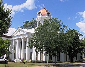
Swain County Courthouse
|
||
|
||
| Motto(s):
"A natural gem set in the Great Smoky Mountains."
"Live here. Play here. Thrive here." |
||
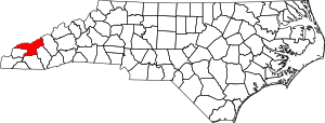
Location within the U.S. state of North Carolina
|
||
 North Carolina's location within the U.S. |
||
| Country | ||
| State | ||
| Founded | 1871 | |
| Named for | David L. Swain | |
| Seat | Bryson City | |
| Largest community | Cherokee | |
| Area | ||
| • Total | 540.25 sq mi (1,399.2 km2) | |
| • Land | 527.73 sq mi (1,366.8 km2) | |
| • Water | 12.52 sq mi (32.4 km2) 2.32% | |
| Population
(2020)
|
||
| • Total | 14,117 | |
| • Estimate
(2023)
|
13,916 | |
| • Density | 26.75/sq mi (10.33/km2) | |
| Time zone | UTC−5 (Eastern) | |
| • Summer (DST) | UTC−4 (EDT) | |
| Congressional district | 11th | |
Swain County is a county in the far western part of North Carolina. In 2020, about 14,117 people lived there. The main town and county seat is Bryson City.
Four important rivers flow through Swain County's mountains: the Nantahala River, Oconaluftee River, Tuckaseegee River, and Little Tennessee River. For thousands of years, different groups of Indigenous peoples lived in these river valleys. This includes people from the South Appalachian Mississippian culture and the Cherokee people. Today, about 29% of the people in Swain County are Native Americans, mostly from the Eastern Band of Cherokee Indians.
Contents
History of Swain County
This area has been home to different groups of Indigenous peoples for thousands of years. They settled in the valleys of the rivers. During the Woodland and South Appalachian Mississippian culture times (starting around 1000 CE), people built large earth mounds. These mounds were important public places in their main villages. Early European explorers in the 1500s likely met these groups.
The Cherokee People
The historic Cherokee people became the main group living in this large area. Their homeland included parts of what is now North Carolina, South Carolina, Tennessee, Georgia, and Alabama. Many Cherokee towns were along the Tuckaseegee River in this county. One very important town was Kituwa, which the Cherokee call their 'mother town'. The Eastern Band of Cherokee Indians (EBCI) bought the Kituwa mound and old town site in 1996. They now protect it as a sacred place.
European Settlers and Indian Removal
After the American Revolutionary War, more European Americans moved into this land. They wanted new farms and homes west of the Appalachian Mountains. This led to more conflicts with the Cherokee and other tribes. In 1830, President Andrew Jackson and Congress passed the Indian Removal Act. This law forced many Native American tribes, including most of the Cherokee, to move west of the Mississippi River. This difficult journey is often called the Trail of Tears.
Swain County grew slowly because it was quite isolated. It was officially formed in 1871. This happened during the Reconstruction era, after the Civil War. The county was made from parts of Jackson and Macon counties. It was named after David L. Swain. He was the governor of North Carolina from 1832 to 1835. He was also the president of the University of North Carolina for many years.
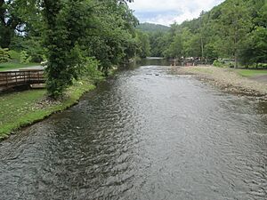
Bryson City became the county seat. It grew on both sides of the Tuckaseegee River. The river flows around Bryson City Island Park before reaching Fontana Lake.
In 1868, the U.S. government recognized the Eastern Band of Cherokee Indians. These were Cherokee people who had managed to stay in North Carolina during the forced removal. In the 1870s, they bought land in what is now Swain County. This land is known as the "Qualla Boundary" and is a special land trust. They are the only federally recognized Native American tribe in North Carolina.
Geography
Swain County covers about 540 square miles. Most of this (about 528 square miles) is land, and a small part (about 12.5 square miles) is water.
The county is in the western part of North Carolina, right in the Great Smoky Mountains. Swain County has more of the Great Smoky Mountains National Park than any other county in North Carolina or Tennessee. The highest point in the county is Kuwohi, which is 6,643 feet tall. It's on the border with Tennessee. Kuwohi is the third-highest mountain in North Carolina. You can walk up to an observation tower at its top.
The Nantahala River is one of the most popular rivers for whitewater rafting in the country. It flows into the Little Tennessee River.
Cherokee Lands
The Oconaluftee River flows through Swain County and the town of Cherokee. This is where the Eastern Band of Cherokee Indians is based. Their special land, the Qualla Boundary, is in both Swain and Jackson counties. The Oconaluftee River flows into the Tuckaseegee River. Long ago, important Cherokee towns were built along both of these rivers. The Tuckaseegee then flows into the Little Tennessee River.
Protected Areas
Swain County is home to parts of several important natural areas:
- Blue Ridge Parkway
- Great Smoky Mountains National Park
- Nantahala National Forest
There are also state and local protected areas like:
- Nantahala National Forest Game Land
- Needmore Game Land
- Shuckstack Fire Tower
- William H. Silver Game Land
Major Water Bodies
Many creeks and rivers flow through Swain County, including:
- Brush Creek
- Bunches Creek
- Cullasaja River
- Deep Creek
- Fontana Lake
- Little Tennessee River
- Nantahala River
- Oconaluftee River
- Tuckasegee River
Neighboring Counties
Swain County shares borders with these other counties:
- Sevier County, Tennessee – to the north
- Haywood County – to the east
- Jackson County – to the southeast
- Macon County – to the south
- Graham County – to the southwest
- Blount County, Tennessee – to the northwest
Main Roads
Important roads that go through Swain County include:
 US 19
US 19 US 74
US 74 US 129
 US 441
 NC 28
NC 28
Transportation
- Bryson City Depot
- Great Smoky Mountains Railroad, a train company based in Bryson City
- Swain Public Transit, which offers rides around the county
People and Population
Demographics is the study of a population. It looks at things like age, race, and how many people live in an area.
2020 Census Information
| Race | Number | Percentage |
|---|---|---|
| White (non-Hispanic) | 8,541 | 60.5% |
| Black or African American (non-Hispanic) | 102 | 0.72% |
| Native American | 4,030 | 28.55% |
| Asian | 53 | 0.38% |
| Pacific Islander | 10 | 0.07% |
| Other/Mixed | 789 | 5.59% |
| Hispanic or Latino | 592 | 4.19% |
In 2020, there were 14,117 people living in Swain County. There were 5,620 households and 3,615 families.
Education
Most of Swain County is served by Swain County Schools. The part of the county within the Qualla Boundary is served by Cherokee Central Schools. Students attend Swain County High School or Cherokee Central High School.
Local News
The local newspaper for Swain County is called the Smoky Mountain Times. It is published in Bryson City.
Communities
Town
- Bryson City (This is the county seat, meaning it's the main administrative town.)
Census-designated places
These are areas that are like towns but are not officially incorporated as towns.
- Cherokee (This is the largest community and the main town for the Eastern Band of Cherokee Indians.)
- Whittier
Other Communities
These are smaller, unincorporated communities:
Townships
Townships are smaller divisions of a county.
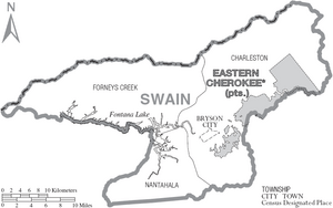
- Charleston
- Forneys Creek
- Nantahala
See also
 In Spanish: Condado de Swain para niños
 | Audre Lorde |
 | John Berry Meachum |
 | Ferdinand Lee Barnett |


