
Kuwohi facts for kids
Quick facts for kids Kuwohi (Cherokee) |
|
|---|---|
| Clingmans Dome | |

Kuwohi as seen from Sevierville, Tennessee
|
|
| Highest point | |
| Elevation | 6,644 ft (2,025 m) |
| Prominence | 4,503 ft (1,373 m) |
| Listing |
|
| Geography | |
| Location | |
| Parent range | Great Smoky Mountains |
| Topo map | USGS Clingmans Dome |
| Climbing | |
| Easiest route | Short paved trail hike |


Kuwohi (Cherokee: ᎫᏩᎯ), also known by its former name Clingmans Dome, is a tall mountain in the Great Smoky Mountains. It sits on the border of Tennessee and North Carolina in the Southeastern United States.
Standing at about 6,643 feet (2,025 meters) high, Kuwohi is the highest mountain in the Great Smoky Mountains National Park. It is also the highest point in Tennessee. Plus, it's the tallest spot along the 2,192-mile (3,528 km) Appalachian Trail. Only two other mountains in eastern North America are taller: Mount Mitchell and Mount Craig.
Contents
What is Kuwohi like?
Kuwohi has two smaller peaks nearby. Mount Buckley is to the west, and Mount Love is to the east. Many important streams start on the sides of Kuwohi. These include Little River on the north side, and Forney Creek and Noland Creek on the south side. All the water from the mountain flows into the Tennessee River.
Kuwohi is a protected area within the Great Smoky Mountains National Park. A paved road leads to it from U.S. Highway 441 at Newfound Gap. At the very top of the mountain, there's a 45-foot (14-meter) tall concrete observation tower. This tower was built in 1959 and is a historic landmark. It offers amazing views of the mountains all around. There's also an air quality station here, which helps check how clean the air is.
The forest on Kuwohi is a special type called a Southern Appalachian spruce-fir forest. These forests only grow at very high elevations in the southeastern U.S. They are more like forests you'd find in colder, northern places. Sadly, many of the Fraser fir trees on Kuwohi have died. This happened because of tiny insects called balsam woolly adelgids, which are not native to the area.
The Observation Tower
|
Clingmans Dome Observation Tower
|
|
 |
|
| Area | 1.4 acres (0.57 ha) |
|---|---|
| Built | 1959 |
| Architect | Bebb and Olson |
| Architectural style | Modern |
| NRHP reference No. | 12000515 |
| Added to NRHP | August 15, 2012 |
The observation tower was built in 1959. It has a circular platform at the top that you reach by walking up a spiral ramp. The ramp is 375 feet (114 meters) long and goes up slowly, making it easy to walk. From the top, you get a full 360-degree view of the mountains. Signs on the platform point out different peaks, towns, and other features far away. On clear days, you can see up to 100 miles (160 km)!
This tower was one of nine built as part of the "Mission 66" program. This program helped the National Park Service improve its parks after World War II. The tower's modern design, using a lot of concrete, was different from older park buildings. Some people thought it looked too "city-like," but similar towers were built elsewhere.
The original design for the tower was changed a few times. The architect, Hubert Bebb, first planned a stone tower with a fire lookout. But park officials decided a fire lookout wasn't needed. They also preferred a ramp instead of stairs, which was a good idea for visitors. The tower cost about $57,000 to build and was finished in October 1959.
How to visit Kuwohi

Kuwohi is the easiest mountain to reach in the Great Smoky Mountains National Park. The 7-mile (11 km) Clingmans Dome Road is open from April 1 to November 30 each year. This road leads to a parking area about 330 feet (100 meters) below the summit. From the parking lot, a short, paved trail leads to the observation tower. Along the trail, you'll find a small visitor center and park store. The trail shows you the unique spruce-fir forest, which can be windy and harsh.
The Appalachian Trail (A.T.) also crosses Kuwohi, passing right near the observation tower. You can hike to the mountain from Newfound Gap on the A.T., which is the only way to reach it in winter. Several other hiking trails also start or end at Kuwohi, like the Forney Ridge Trail and the Forney Creek Trail. The Mountains-to-Sea Trail, which goes all the way to the Outer Banks of North Carolina, also begins here.
History of Kuwohi

The Cherokee people have always called this mountain Kuwahi or Kuwohi (ᎫᏩᎯ), which means 'mulberry place'. According to an old Cherokee story, the mountain was home to the White Bear, the leader of all bears. It was also a place where bears held important meetings. The Cherokee also believed in a magical lake called Ataga'hi nearby, whose waters could heal wounded bears.
In 1789, the land that is now Tennessee was given to the U.S. government. The border between North Carolina and Tennessee was set along the "Great Iron or Smoky Mountains," which included Kuwohi. Early American settlers called the mountain "Smoky Dome."
In 1859, a geographer named Arnold Henry Guyot renamed the mountain "Clingmans Dome." He named it after Thomas L. Clingman, who explored and mapped the area. Clingman was a general during the American Civil War. Guyot named it after Clingman because Clingman and another professor, Elisha Mitchell, had a disagreement. They argued about which mountain was the highest in the region. Guyot found that Mount Mitchell was actually a little taller than Smoky Dome.
On June 12, 1946, a large plane called a Boeing B-29 Superfortress crashed near the top of Kuwohi. Sadly, all twelve people on board died.
In 2022, two members of the Eastern Band of Cherokee Indians, Lavita Hill and Mary "Missy" Crowe, started an effort to change the mountain's name back to Kuwahi. They explained that Kuwahi is very important to the Cherokee people. It was a sacred place where medicine people prayed and sought guidance. The Cherokee Tribal Council supported this name change. They saw it as a chance to teach people about the Cherokee language and remind everyone that this land was originally Cherokee homeland.
The official process to change the name began with an application to the United States Board on Geographic Names. Many groups supported the change, including the Buncombe County Board of Commissioners and the National Park Service. The name change to Kuwohi was officially approved and announced on September 18, 2024.
How Kuwohi was formed
Kuwohi is made up of rocks from a geological formation called the Copperhill Formation. These rocks are mostly a type of sandstone called metagreywacke and a rock with pebbles in it called metaconglomerate. These rocks are part of a larger group called the Ocoee Supergroup. These rocks formed about 560 million years ago from sand and mud that settled in deep basins.
Over millions of years, these rocks were squeezed and heated by powerful forces inside the Earth. This process is called metamorphism. It happened during several mountain-building events, or orogenies, like the Taconic, Acadian, and Alleghanian orogenies. These events caused the rocks to fold and break, pushing them up to form the Appalachian Mountains we see today. Even now, the mountains are slowly being lifted up and worn down by weather.
You can see some of these rocks at the Forney Ridge Parking Lot near the end of Clingmans Dome Road. Here, you can find large rocks with pebbles and egg-shaped lumps inside them. These lumps often weather away, leaving holes in the rock. The soil on Kuwohi is usually dark brown and a bit sandy, and it's quite acidic.
Weather at Kuwohi
The top of Kuwohi has a humid continental climate. This means it has cold winters and mild summers. The areas around it have an oceanic climate. The region is also known as part of the Appalachian temperate rainforest because it gets a lot of rain and moisture.
| Climate data for Kuwohi | |||||||||||||
|---|---|---|---|---|---|---|---|---|---|---|---|---|---|
| Month | Jan | Feb | Mar | Apr | May | Jun | Jul | Aug | Sep | Oct | Nov | Dec | Year |
| Mean daily maximum °F (°C) | 35 (2) |
35 (2) |
39 (4) |
49 (9) |
57 (14) |
63 (17) |
65 (18) |
64 (18) |
60 (16) |
53 (12) |
42 (6) |
37 (3) |
50 (10) |
| Mean daily minimum °F (°C) | 19 (−7) |
18 (−8) |
24 (−4) |
34 (1) |
43 (6) |
49 (9) |
53 (12) |
52 (11) |
47 (8) |
38 (3) |
28 (−2) |
21 (−6) |
36 (2) |
| Average precipitation inches (mm) | 7.0 (180) |
8.2 (210) |
8.2 (210) |
6.5 (170) |
6.0 (150) |
6.9 (180) |
8.3 (210) |
6.8 (170) |
5.1 (130) |
5.4 (140) |
6.4 (160) |
7.3 (190) |
82.1 (2,100) |
| Average snowfall inches (cm) | 18 (46) |
20 (51) |
26 (66) |
5 (13) |
trace | 0 (0) |
0 (0) |
0 (0) |
trace | 2 (5.1) |
5 (13) |
8 (20) |
84 (214.1) |
Images for kids
-
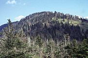
Kuwohi, with groves of dead trees
-
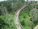
Base of the helical walkway ramp to the top of the observation tower
-
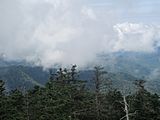
Mountains north of the observation tower obscured by low clouds.


See also
 In Spanish: Clingmans Dome para niños
