Buncombe County, North Carolina facts for kids
Quick facts for kids
Buncombe County
|
|||||
|---|---|---|---|---|---|

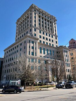
Buncombe County Courthouse in Asheville
|
|||||
|
|||||
| Motto(s):
"People To Match Our Mountains"
|
|||||

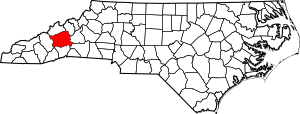
Location within the U.S. state of North Carolina
|
|||||
 North Carolina's location within the U.S. |
|||||
| Country | |||||
| State | |||||
| Founded | 1792 | ||||
| Named for | Edward Buncombe | ||||
| Seat | Asheville | ||||
| Largest municipality | Asheville | ||||
| Area | |||||
| • Total | 659.95 sq mi (1,709.3 km2) | ||||
| • Land | 656.50 sq mi (1,700.3 km2) | ||||
| • Water | 3.45 sq mi (8.9 km2) 0.52% | ||||
| Population
(2020)
|
|||||
| • Total | 269,452 | ||||
| • Estimate
(2023)
|
275,901 | ||||
| • Density | 410.37/sq mi (158.44/km2) | ||||
| Time zone | UTC−5 (Eastern) | ||||
| • Summer (DST) | UTC−4 (EDT) | ||||
| Congressional district | 11th | ||||
Buncombe County (pronounced BUNK-um) is a county located in the U.S. state of North Carolina. It is found in the beautiful Western North Carolina region. In 2020, about 269,452 people lived here, making it the 7th most populated county in North Carolina. The main town and county seat is Asheville, which is also the largest city. Buncombe County is part of the larger Asheville Metropolitan Statistical Area.
Contents
History of Buncombe County
The land that is now Buncombe County was originally home to the Anigiduwagi, also known as the Cherokee people. In the early 1700s, Europeans, mostly from Germany, Scotland, and England, began to settle in the area. Some of the first permanent European settlers arrived in 1784. Sadly, these settlers often broke their agreements with the Cherokee, slowly forcing them off their land in Buncombe County.
Forming the County
In December 1792 and April 1793, a local argument happened about where the county seat (the main town for government) should be. People on opposite sides of the Swannanoa River disagreed. One group wanted it north of the river, where Asheville is now. The other group wanted it south, in what is now the southern part of Asheville.
Buncombe County was officially formed by European Americans after the American Revolutionary War. The first meeting of the county government took place in April 1792 in Colonel William Davidson's barn, which is now part of the famous Biltmore Estate.
At first, important documents like land deeds had to be recorded in Morganton, which was far away. Roads were very bad, making it hard for people to travel. So, in December 1792, seven men met to choose a place for the county's first courthouse. It was built where Pack Square in Asheville is today.
How Buncombe County Got Its Name
The county was created in 1791 from parts of Burke and Rutherford counties. It was named after Edward Buncombe, a colonel who fought in the American Revolutionary War. He was captured during the Battle of Germantown. Before being named Buncombe, the county was almost called "Union County." At first, this large county stretched all the way to the Tennessee border.
Many early settlers in the area were Baptists. In 1807, pastors from six churches formed the French Broad Association of Baptist churches.
Changes Over Time
As more people moved to this part of North Carolina, parts of Buncombe County were used to create new counties.
- In 1808, the western part became Haywood County.
- In 1833, parts of Burke and Buncombe counties formed Yancey County.
- In 1838, the southern part of Buncombe became Henderson County.
- In 1851, parts of Buncombe and Yancey counties formed Madison County.
- Finally, in 1925, a small part of McDowell County was added to Buncombe County.
The Word "Bunkum"
In 1820, a U.S. Congressman named Felix Walker, whose district included Buncombe County, accidentally added a new word to the English language. During a long debate in Congress, other members wanted to vote on an important issue. But Felix Walker insisted on giving a speech because he said his voters expected him to speak "for Buncombe." People later joked that his speech wasn't just for Buncombe, it was Buncombe – meaning it was empty, nonsensical talk. This is how the word "bunkum" (and later "bunk") came to mean foolish talk, and it's also where the word "debunk" comes from.
Geography of Buncombe County
Buncombe County covers about 659.95 square miles. Most of this (656.50 square miles) is land, and a small part (3.45 square miles) is water.
The French Broad River flows into the county from the south and continues north into Madison County. The Swannanoa River starts in northeast Buncombe County, near Mount Mitchell, and joins the French Broad River in Asheville. Mount Mitchell is the highest point in the eastern United States, but its very top is in the next county over. The highest point in Buncombe County is Potato Knob, which is over 6,400 feet tall.
In 2003, a big project was finished: Interstate 26 was extended from Mars Hill (north of Asheville) to Johnson City, Tennessee. This was a huge construction job through the Blue Ridge Mountains that took 20 years and cost half a billion dollars!
Protected Natural Areas
Buncombe County is home to many beautiful natural areas that are protected.
National Protected Areas
- Blue Ridge Parkway (a scenic road)
- Craggy Gardens
- Pisgah National Forest (part of a large forest)
- Mount Pisgah
- Nantahala National Forest (part of another large forest)
State and Local Protected Areas/Sites
- Asheville Watershed
- Beaver Lake Bird Sanctuary
- Big Ivy Historical Park
- Biltmore Estate
- Chimney Rock State Park (part)
- Collier Cove Nature Preserve
- The North Carolina Arboretum
- Pisgah National Forest Game Land (part)
- Pisgah View State Park (part)
- Sandy Mush Game Land (part)
- Thomas Wolfe House
- Vance Birthplace
- Western North Carolina Nature Center
- Young Forest
Major Water Bodies
Buncombe County has many rivers, creeks, and lakes:
- Beaver Lake
- Beaverdam Creek
- Bent Creek
- Broad River
- Burnett Reservoir
- Cane Creek
- Flat Creek
- French Broad River
- Lake Julian
- Lake Kenilworth
- Lake Craig
- Lake Powhatan
- Lake Louise
- Left Fork Swannanoa River
- Little Pole Creek
- Long Valley Lake
- Newfound Creek
- North Fork Reservoir
- North Fork Swannanoa River
- Pole Creek
- Reems Creek
- Right Fork Swannanoa River
- Swannanoa River
- Tom Creek
- Turkey Creek
Neighboring Counties
Buncombe County shares borders with these other counties:
- Madison County – to the north
- Yancey County – to the northeast
- McDowell County – to the east
- Rutherford County – to the southeast
- Henderson County – to the south
- Transylvania County – to the southwest
- Haywood County – to the west
Main Roads and Transportation
Major Infrastructure
- Asheville Regional Airport
People of Buncombe County (Demographics)
| Historical population | |||
|---|---|---|---|
| Census | Pop. | %± | |
| 1800 | 5,812 | — | |
| 1810 | 9,277 | 59.6% | |
| 1820 | 10,542 | 13.6% | |
| 1830 | 16,281 | 54.4% | |
| 1840 | 10,084 | −38.1% | |
| 1850 | 13,425 | 33.1% | |
| 1860 | 12,654 | −5.7% | |
| 1870 | 15,412 | 21.8% | |
| 1880 | 21,909 | 42.2% | |
| 1890 | 35,266 | 61.0% | |
| 1900 | 44,288 | 25.6% | |
| 1910 | 49,798 | 12.4% | |
| 1920 | 64,148 | 28.8% | |
| 1930 | 97,937 | 52.7% | |
| 1940 | 108,755 | 11.0% | |
| 1950 | 124,403 | 14.4% | |
| 1960 | 130,074 | 4.6% | |
| 1970 | 145,056 | 11.5% | |
| 1980 | 160,934 | 10.9% | |
| 1990 | 174,821 | 8.6% | |
| 2000 | 206,330 | 18.0% | |
| 2010 | 238,318 | 15.5% | |
| 2020 | 269,452 | 13.1% | |
| 2023 (est.) | 275,901 | 15.8% | |
| U.S. Decennial Census 1790–1960 1900–1990 1990–2000 2010 2020 |
|||
Since 1970, the number of people living in Buncombe County has grown steadily. Many retirees and people buying second homes have moved here from other areas.
2020 Census Information
| Race | Number | Percentage |
|---|---|---|
| White (non-Hispanic) | 214,862 | 79.74% |
| Black or African American (non-Hispanic) | 15,017 | 5.57% |
| Native American | 727 | 0.27% |
| Asian | 3,274 | 1.22% |
| Pacific Islander | 467 | 0.17% |
| Other/Mixed | 13,183 | 4.89% |
| Hispanic or Latino | 21,922 | 8.14% |
According to the 2020 census, there were 269,452 people living in the county. This included 106,741 households and 63,675 families. From 2010 to 2020, Buncombe County's population grew by 31,104 people, which is a 13.0% increase. This made it the fastest-growing county in Western North Carolina during that decade.
Economy of Buncombe County
The North Carolina Department of Commerce reported that in September 2024, Buncombe County had the lowest unemployment rate in all of North Carolina, at just 2.5 percent. However, after a big storm called Hurricane Helene affected the region in October, the unemployment rate went up to 8.8 percent, making it the highest in the state for that month.
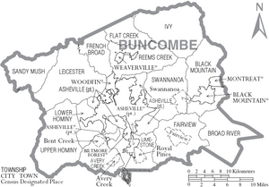
Communities in Buncombe County
City
- Asheville (This is the county seat and the largest city.)
Towns
Townships
- Asheville
- Avery Creek
- Black Mountain
- Broad River
- Fairview
- Flat Creek
- French Broad
- Hazel
- Ivy
- Leicester
- Limestone
- Lower Hominy
- Reems Creek
- Sandy Mush
- Swannanoa
- Woodfin
- Upper Hominy
Census-Designated Places
These are areas that are like towns but are not officially incorporated as cities or towns.
Unincorporated Communities
These are smaller communities that are not part of any official city or town.
- Alexander
- Arden
- Beaverdam
- Candler
- Coburn
- Enka
- Flat Creek
- Forks of Ivy
- Jupiter
- Leicester
- Oak Park
- Ridgecrest
- Sandymush
- Skyland
- Stocksville
- Wilson
See also
 In Spanish: Condado de Buncombe para niños
 | Bessie Coleman |
 | Spann Watson |
 | Jill E. Brown |
 | Sherman W. White |


