
Swannanoa River facts for kids
Quick facts for kids Swannanoa River |
|
|---|---|

Swannanoa River at Asheville, North Carolina
|
|


Location of Swannanoa River mouth
|
|
| Other name(s) | Tributary to French Broad River |
| Country | United States |
| State | North Carolina |
| County | Buncombe |
| City | Black Mountain Swannanoa Asheville |
| Physical characteristics | |
| Main source | divide between Swannanoa River and Catawba River about 0.25 miles south of Swannanoa Gap 2,790 ft (850 m) 35°37′11″N 082°17′40″W / 35.61972°N 82.29444°W |
| River mouth | French Broad River Asheville, North Carolina 1,968 ft (600 m) 35°34′05″N 082°33′49″W / 35.56806°N 82.56361°W |
| Length | 24.83 mi (39.96 km) |
| Basin features | |
| Progression | west |
| River system | French Broad River |
| Basin size | 132.77 square miles (343.9 km2) |
| Tributaries |
|
| Bridges | Yates Avenue, Old US 70, Broadway Street, S Blue Ridge Road, I-40, US 70, Paton Hill Road, Riverwood Road, Davidson Road, Warren Wilson College Road, Tunnel Road (US 70), E Azalea Road, I-240, S Tunnel Road, Biltmore Avenue, Biltmore Estate Road |
The Swannanoa River flows through the beautiful Swannanoa Valley in Western North Carolina. It is a major branch, also called a tributary, of the French Broad River. The river starts high up near Black Mountain. Another important stream, Flat Creek, also feeds into it from Mount Mitchell.
The Swannanoa River travels about 22 miles (35 kilometers). It stays entirely within Buncombe County. The river finally meets the French Broad River in Asheville. This meeting point is now part of the large Biltmore Estate.
Contents
History of the River Area
The land around the Swannanoa River has a long history. It was once home to many Native American groups. One special place is an ancient earth mound called Biltmore Mound. It is located near the river on the Biltmore Estate.
The Biltmore Mound
Scientists have studied the Biltmore Mound. They found that early Native Americans started building it between 400 and 550 CE. The Cherokee people later lived in this area. It was part of their traditional homeland.
The Cherokee called this spot Untokiasdiyi. This means "where they race." They used it as a meeting place. They also held competitive games and feasts there.
Changes Over Time
In 1819, the Cherokee gave up their land in this area. This happened due to pressure from European-American settlers. The site near the Swannanoa River was later left empty and became overgrown. Farming in the area also made the mound shorter.
The mound was rediscovered in 1984. A team from Appalachian State University began digging there in 2000. They worked for over two years to learn about its history.
Importance of the River
The Swannanoa River is very important to Buncombe County. It provides drinking water for the Asheville area. It also offers many fun activities. People can enjoy fishing, kayaking, and other outdoor sports.
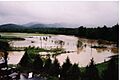
River Flooding in 2004
In September 2004, the Swannanoa River experienced major flooding. This happened because of very heavy rain. The rain came from the leftover storms of Hurricane Frances and Hurricane Ivan.
The flood caused a lot of damage. It especially affected the Biltmore Village part of Asheville. Other towns along the river also saw significant damage.
Images for kids
-
Swannanoa River flooding after Hurricane Frances, September 2004

