Catawba River facts for kids
Quick facts for kids Catawba River |
|
|---|---|
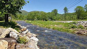
A view of the Catawba River in McDowell County, North Carolina
|
|
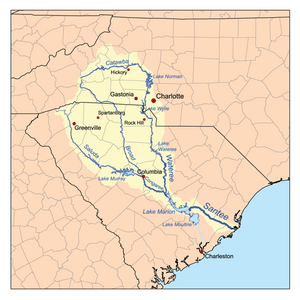
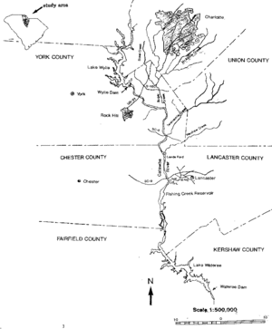
Map of the Santee River watershed showing the Catawba River
|
|
|
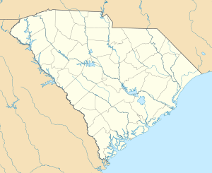
Location of the mouth of the Catawba River in South Carolina
|
|
| Native name | Eswa-Taroa |
| Country | United States |
| States | North Carolina, South Carolina |
| Counties | McDowell NC, Caldwell NC, Burke NC, Alexander NC, Catawba NC, Iredell NC, Lincoln NC, Gaston NC, Mecklenburg NC, York SC, Lancaster SC, Fairfield SC |
| Physical characteristics | |
| Main source | Evans Knob Ridgecrest, North Carolina 3,044 ft (928 m) 35°36′04″N 82°17′06″W / 35.60111°N 82.28500°W |
| River mouth | Wateree River Liberty Hill, South Carolina 223 ft (68 m) 34°28′01″N 80°53′20″W / 34.46694°N 80.88889°W |
| Basin features | |
| Progression | Catawba → Wateree → Santee → Atlantic Ocean |
| River system | Catawba River |
| Waterbodies | Lake James, Rhodhiss Lake, Lake Hickory, Lookout Shoals Lake, Lake Norman, Mountain Island Lake, Lake Wylie, Fishing Creek Reservoir,Great Falls Reservoir, Cedar Creek Reservoir, Lake Wateree |
| Waterfalls | Catawba Falls |
The Catawba River is a long and important river in the United States. It starts in Western North Carolina and flows into South Carolina. In South Carolina, it changes its name to the Wateree River. The river is about 220 miles (350 km) long.
It begins high up in the Appalachian Mountains. As it flows, it goes through an area called the Piedmont. Along its path, many dams have been built. These dams help control floods and create hydroelectricity, which is power made from moving water.
The river gets its name from the Catawba Native American tribe. This tribe has lived along the river's banks for a very long time. In their own language, they call themselves "yeh is-WAH h’reh," which means "people of the river."
The Catawba River starts in the Blue Ridge Mountains in McDowell County, North Carolina. This is about 20 miles (30 km) east of Asheville. It flows east-northeast and goes over two waterfalls: Upper Catawba Falls and Catawba Falls.
After the waterfalls, the river flows into Lake James, a large reservoir. Then it joins the Linville River. It continues past Morganton, then through Lake Rhodhiss and Lake Hickory. These lakes are just north of Hickory.
Next, the river flows into the huge Lake Norman reservoir. From Lake Norman, it heads south, passing west of Charlotte. It then flows through two more reservoirs, Mountain Island Lake and Lake Wylie. The river leaves these lakes about 10 miles (15 km) south of the North Carolina-South Carolina border. The South Fork Catawba River also joins the Catawba River in Lake Wylie.
Once in northern South Carolina, the river flows past Rock Hill. It then goes through Fishing Creek Reservoir near Great Falls. Finally, it reaches the Lake Wateree reservoir, about 30 miles (50 km) northeast of Columbia. At this point, where it meets Wateree Creek, the river becomes known as the Wateree River.
Contents
Dams Along the Catawba River
The Catawba River has many dams built on it. These dams create large lakes, also called reservoirs. They are important for controlling water flow and making electricity.
Here are some of the main dams on the Catawba River:
Dams in North Carolina
- Lake James Dam
- Rhodhiss Dam
- Oxford Dam
- Lookout Shoals Dam
- Cowans Ford Dam, which created Lake Norman
- Mountain Island Lake Dam
Dams in South Carolina
- Lake Wylie Dam in India Hook
- Fishing Creek Reservoir in Great Falls
- Dearborn-Great Falls Dam
- Cedar Creek Reservoir Dam
- Lake Wateree Dam
Catawba River: A River at Risk
The Catawba River faces several challenges, including droughts and pollution. People and groups are working to protect it.
Droughts and Water Use
In 2007, the Catawba River basin experienced a very serious drought. A drought means there is much less rain than usual. This caused water levels to drop. The company that manages the river, Duke Energy, had to ask people to use less water. This was to make sure there was enough water for everyone and for the river's health.
Environmental Concerns
In 2008, an environmental group called American Rivers said the Catawba-Wateree River was "the most endangered river in America." They pointed to several reasons:
- The ongoing drought.
- The many dams on the river.
- The effects of global warming.
- Too much building and development along the riverbanks.
In 2008, South Carolina made the Catawba a "state scenic river." This helps bring attention to the river's beauty and importance. It also allows groups to work together on river issues.
Pollution and Water Quality
The EPA has noted concerns about waste material ponds near the river. These ponds hold "coal ash," which is a leftover material from burning coal to make electricity. Coal ash can contain harmful substances like arsenic and mercury.
In 2014, Duke Energy was allowed to move some coal ash into Lake Norman to fix a pipe. This raised worries about water quality in the lake. In 2015, a sinkhole formed near a coal ash area at the Marshall Steam Station, which also caused concern about the lake's water.
Special Plants in the River
The Catawba River basin is one of the few places where a special flower called the Shoals spider lily (Hymenocallis coronaria) still grows. There is a large group of these lilies at Landsford Canal State Park. Protecting the river helps protect these unique plants.
River Crossings
Many roads and highways cross over the Catawba River. Here are some of them:
Crossings in North Carolina
- From Lake James to Lake Norman:
- Power House Road
- Watermill Glen Alpine Road
- Independence Blvd in Morganton
- N Green Street (N.C. 181) in Morganton
- U.S. 64 in Morganton
- Huffman Bridge
- Castle Bridge near Rutherford College
- Rhodhiss Road in Rhodhiss
- U.S. 321 in Hickory
- N.C. 127 near Hickory
- N.C. 16 below Oxford Dam
- Interstate 40
- US 70 in Catawba
- Buffalo Shoals Road (Iredell County)/Hudson Chapel Road (Catawba County) over Lake Norman
- N.C. 150 over Lake Norman
- From Lake Norman to the South Carolina border:
- N.C. 73 bridge at Cowans Ford Dam
- Rozzelle Bridge on Brookshire Blvd (N.C. 16) over Mountain Island Lake
- E. Charlotte Avenue in Mount Holly
- Interstate 85
- Wilkinson Blvd U.S. 29 and U.S. 74 in Belmont
- Buster Boyd Bridge over Lake Wylie
Crossings in South Carolina
- From Lake Wylie to Lake Wateree:
- Interstate 77 between Rock Hill and Ft. Mill
- Cherry Road U.S. 21 between Rock Hill and Ft. Mill
- (Future) Dave Lyle Boulevard in Rock Hill
- Rock Hill Highway (S.C. 5) in Catawba
- Lancaster-Chester Highway (S.C. 9)
- Francis Avenue in Great Falls
See also
 In Spanish: Río Catawba para niños
 | Stephanie Wilson |
 | Charles Bolden |
 | Ronald McNair |
 | Frederick D. Gregory |


