Gaston County, North Carolina facts for kids
Quick facts for kids
Gaston County
|
|||||
|---|---|---|---|---|---|

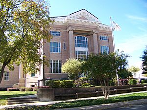
Gaston County Courthouse
|
|||||
|
|||||
| Motto(s):
"Local Strengths. Global Success."
|
|||||

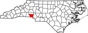
Location within the U.S. state of North Carolina
|
|||||
 North Carolina's location within the U.S. |
|||||
| Country | |||||
| State | |||||
| Founded | 1846 | ||||
| Named for | William Gaston | ||||
| Seat | Gastonia | ||||
| Largest community | Gastonia | ||||
| Area | |||||
| • Total | 363.68 sq mi (941.9 km2) | ||||
| • Land | 355.75 sq mi (921.4 km2) | ||||
| • Water | 7.93 sq mi (20.5 km2) 2.18% | ||||
| Population
(2020)
|
|||||
| • Total | 227,943 | ||||
| • Estimate
(2023)
|
237,242 | ||||
| • Density | 640.74/sq mi (247.39/km2) | ||||
| Time zone | UTC−5 (Eastern) | ||||
| • Summer (DST) | UTC−4 (EDT) | ||||
| Congressional districts | 10th, 14th | ||||
Gaston County is a county in the U.S. state of North Carolina. In 2020, about 227,943 people lived there. The main city and county seat is Gastonia. Before 1911, Dallas was the county seat.
Gaston County is part of the larger Charlotte-Concord-Gastonia metropolitan area. This area had an estimated population of over 2.8 million people in 2023. The county is located in the southern Piedmont region of North Carolina.
Gaston County is the tenth most populated county in North Carolina. It covers about 364 square miles (943 square kilometers). The county has fifteen official towns and cities. There are also many smaller communities that are not officially towns, like Hardin and Lucia.
Contents
History of Gaston County
The first European settlers in Gaston County were mainly from Scotland, Ireland, Germany, and England. In the 1750s, settlers built a fort near the Catawba River. This was to protect themselves from the Cherokee tribe. However, the fort was never attacked.
Peace came when the border between North Carolina and South Carolina was set in 1772. After this, most of the Catawba tribe moved to a special land area called a reservation.
Most early farms in the area were small. They were worked by white farmers of English background. North Carolina's rules limited the size of land given out. In Gaston County, these land grants were usually about 400 acres (1.6 square kilometers) each.
Gaston County was created in 1846. It was formed from parts of Lincoln County. The county is named after William Gaston. He was a U.S. Representative from North Carolina and a judge on the state's highest court.
Between 1845 and 1848, Gaston County saw a big growth in factories. The first three cotton mills in the county were built during this time. Some say the first mill was built by Thomas R. Tate on Mountain Island. Others believe it was built by the Linebergers near McAdenville. The Stowesville Mill, founded by Jasper Stowe, was also one of the first. Gaston County became a leader in cotton production in the country.
The county seat moved from Dallas to Gastonia in 1911.
Geography of Gaston County
Gaston County covers about 363.68 square miles (941.9 square kilometers). Most of this is land, with a small part being water. The county is in the southern Piedmont region. This area has gently rolling hills, river valleys, and some low mountains.
Most of Gaston County's water flows into the Catawba River. The Catawba River forms the eastern border of the county. The South Fork Catawba River also flows through the county.
The highest point in Gaston County is King's Pinnacle. This rocky peak rises over 800 feet (244 meters) above Gastonia. King's Pinnacle is 1,690 feet (515 meters) above sea level. It is part of Crowders Mountain State Park.
Protected Areas and Sites
- Crowders Mountain State Park
- Daniel Stowe Botanical Garden
- Mountain Island Educational State Forest (part)
- Seven Oaks Preserve Trail
Major Water Bodies
- Beaverdam Creek
- Catawba Creek
- Catawba River
- Crowders Creek
- Dutchmans Creek
- Little Beaverdam Creek
- Mountain Island Lake
- Rankin Lake
- South Crowders Creek
- South Fork Catawba River
- South Stanly Creek
- Stanly Creek
Neighboring Counties
- Lincoln County – north
- Mecklenburg County – east
- York County, South Carolina – south
- Cleveland County – west
Population of Gaston County
| Historical population | |||
|---|---|---|---|
| Census | Pop. | %± | |
| 1850 | 8,073 | — | |
| 1860 | 9,307 | 15.3% | |
| 1870 | 12,602 | 35.4% | |
| 1880 | 14,254 | 13.1% | |
| 1890 | 17,764 | 24.6% | |
| 1900 | 27,903 | 57.1% | |
| 1910 | 37,063 | 32.8% | |
| 1920 | 51,242 | 38.3% | |
| 1930 | 78,093 | 52.4% | |
| 1940 | 87,531 | 12.1% | |
| 1950 | 110,836 | 26.6% | |
| 1960 | 127,074 | 14.7% | |
| 1970 | 148,415 | 16.8% | |
| 1980 | 162,568 | 9.5% | |
| 1990 | 175,093 | 7.7% | |
| 2000 | 190,365 | 8.7% | |
| 2010 | 206,086 | 8.3% | |
| 2020 | 227,943 | 10.6% | |
| 2023 (est.) | 237,242 | 15.1% | |
| U.S. Decennial Census 1790–1960 1900–1990 1990–2000 2010 2020 |
|||
2020 Census Information
In 2020, Gaston County had 227,943 people. There were 85,705 households and 55,868 families living in the county.
| Group | Number | Percentage |
|---|---|---|
| White (not Hispanic) | 153,653 | 67.41% |
| Black or African American (not Hispanic) | 39,762 | 17.44% |
| Native American | 753 | 0.33% |
| Asian | 3,509 | 1.54% |
| Pacific Islander | 59 | 0.03% |
| Other/Mixed | 10,139 | 4.45% |
| Hispanic or Latino | 20,068 | 8.8% |
Transportation and Travel
Major Roads
 I-85
I-85 US 29
US 29 US 74
US 74
 US 74 Bus.
 US 321


 US 321 Bus.
 NC 7
NC 7 NC 16
NC 16
 NC 16 Bus. (Business route)
 NC 27
NC 27 NC 150
 NC 161
 NC 216
 NC 273
 NC 274
 NC 275
 NC 279
Train Service
Gaston County has passenger train service through Amtrak, with a stop in Gastonia. Freight trains are operated by Norfolk Southern Railway, CSX, and Patriot Rail.
The main Norfolk Southern line goes through Kings Mountain, Bessemer City, Gastonia, Ranlo, Lowell, Cramerton, and Belmont.
CSX train lines pass through the northwestern and northeastern parts of the county.
Airports
Charlotte-Douglas International Airport is a large airport with many passenger flights. It is located in nearby Mecklenburg County.
The city of Gastonia also has its own airport, Gastonia Municipal Airport. This airport is for smaller planes and has one runway.
Economy
Piedmont Lithium is a mining company working in Gaston County. They are looking for lithium, a metal used in batteries for electric vehicles and other devices. The company has been drilling samples to see if there is enough lithium to mine.
Education in Gaston County
Public schools in Gaston County are run by the Gaston County Schools system. A board of nine members makes decisions for the schools.
Gaston County Schools has 54 public schools. This includes 9 high schools, 11 middle schools, and 32 elementary schools. There is also an alternative school and a special school for students with disabilities.
There are four charter schools in Gaston County. These include Community Public Charter School and Piedmont Community Charter School.
Gaston County has two colleges. Gaston College in Dallas offers associate degrees and other programs. Belmont Abbey College in Belmont is a Roman Catholic liberal arts college.
The Gaston County Public Library has 10 branches across the county.
Natural Wonders
Gaston County has many important natural areas. These range from Crowders Mountain in the southwest to sites near the Catawba River.
Twelve natural sites in Gaston County are important for the state or region. Six of these sites have the bigleaf magnolia (Magnolia macrophylla). This plant has the largest simple leaf of any plant in cool climates. It also has very large flowers. Most of the bigleaf magnolia sites in North Carolina are in Gaston County.
Two sites are important because they are home to the bog turtle (Glyptemys muhlenbergii). This rare turtle is the most important rare animal in Gaston County.
Crowders Mountain State Park is the largest natural site in the county. It covers over 3,000 acres (12 square kilometers). The park has many different types of plants and animals. Some animals found here are not seen anywhere else in the county.
Another special site is Stagecoach Road. It has the largest and best-preserved granite rock area in the county. This area is home to unique plants like Talinum teretifolium and Sedum smallii.
Fun Places to Visit
The Hoyle Historic Homestead is the oldest building still standing in Gaston County. It was built around 1760 and shows German-American building styles. It is listed on the National Register of Historic Places.
The Daniel Stowe Botanical Garden covers 110 acres (0.45 square kilometers). It is a beautiful place to see many different plants.
The Gaston County Museum is located in the town of Dallas, North Carolina.
The Schiele Museum of Natural History is in Gastonia. It is a science museum and planetarium with interesting exhibits.
Crowder's Mountain State Park is known for its tall cliffs, which drop 150 feet (46 meters). From the top of Crowders Mountain, you can see for more than 20 miles (32 kilometers).
The U.S. National Whitewater Center is a place for outdoor activities. It has a climbing center, mountain-biking trails, and running trails along the Catawba River.
Christmas Town USA is in McAdenville, North Carolina. Every December, this small town lights up with hundreds of thousands of lights. Visitors can walk down Main Street and enjoy the holiday display.
Spencer Mountain is where the old WBTV television transmitter was located. The first TV signal in North Carolina was sent from here in 1949. The tower is still there today.
Communities in Gaston County
Cities
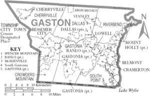
- Belmont
- Bessemer City
- Cherryville
- Gastonia (county seat and largest community)
- Kings Mountain (mostly in Cleveland County)
- Lowell
- Mount Holly
Towns
Townships
Townships are areas of the county that are not part of a city or town. They do not have their own local government.
- Cherryville
- Crowders Mountain
- Dallas
- Gastonia
- Riverbend
- South Point
Unincorporated Communities
These are smaller communities that are not officially towns or cities.
- Alexis
- Ashebrook Park
- Boogertown
- Brown Town
- Crowders
- Hardins
- Lucia
- Mountain Island
- Springdale
- Tryon
See also
 In Spanish: Condado de Gaston para niños
 | Mary Eliza Mahoney |
 | Susie King Taylor |
 | Ida Gray |
 | Eliza Ann Grier |


