
Crowders Mountain State Park facts for kids
Quick facts for kids Crowders Mountain State Park |
|
|---|---|
|
IUCN Category III (Natural Monument)
|
|
 |
|

Crowders Mountain State Park
Location in North Carolina
|
|
| Location | Gaston, North Carolina, United States |
| Area | 5,217 acres (21.11 km2) |
| Elevation | 1,385 ft (422 m) |
| Established | 1974 |
| Named for | Crowder's Mountain |
| Governing body | North Carolina Division of Parks and Recreation |
| Website | Crowders Mountain State Park |
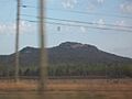
Crowders Mountain State Park is a cool place to visit in Gaston County, North Carolina, in the United States. It's a big park, about 5,217-acre (21.11 km2) in size. The park is close to Kings Mountain, North Carolina and Gastonia, North Carolina. It's famous for its two main peaks: Crowder's Mountain and The Pinnacle.
Crowders Mountain got its name from Crowders Creek, which starts nearby. People used to think it was named after someone named Ulrick Crowder, but that's not true! The tall cliffs at Crowders Mountain are a super popular spot for people who love rock climbing.
Contents
Explore Crowders Mountain Park
This park is home to some unique natural features.
What is a Monadnock?
Crowders Mountain is what scientists call a monadnock. This is a fancy word for an isolated mountain that stands out from the flat land around it. Imagine a big hill rising suddenly from a flat field! Even though they look like mountains, Crowders Mountain and The Pinnacle are actually remnants of much older, taller mountains.
Crowders Mountain rises about 800 feet (240 m) above the land around it. It has very steep rock cliffs that are 100 to 150 feet (46 m) high. The very top of Crowders Mountain is 1,625 feet (495 m) above sea level. Scientists believe this peak is what's left of a huge mountain that formed 400 to 500 million years ago. Over millions of years, wind and water slowly wore it down.
The park is at the northeast end of the Kings Mountain Range. This range is about 16-mile (26 km) long and includes the famous site of the Battle of Kings Mountain. This battle was a very important event during the American Revolution.
Park Peaks
The park has two main peaks that you can explore:
- Crowders Mountain: This peak is 1,625 feet (495 m) tall. It's located in the northeastern part of the park. 35°13′56″N 81°16′35″W / 35.232350°N 81.276439°W
- The Pinnacle: This is the highest point in the park, reaching 1,705 feet (520 m). You'll find it in the western part of the park. 35°12′28″N 81°18′45″W / 35.207817°N 81.312626°W
The park also has a Visitors Center where you can learn more about the area.
Park History
Long ago, before European settlers arrived, large herds of buffalo grazed on the grassy lands that are now part of the park. Native American tribes, like the Cherokee and Catawba, used the area. The Cherokee had a trading route that went right over Crowders Mountain. The peaks also helped mark the hunting grounds for the Catawba and Cherokee people.
Saving the Mountain
In the early 1970s, a company wanted to dig for minerals on Crowders Mountain. But local people, schools, and groups worked together to protect this special place. They convinced the state government that the area was too important to lose. It had unique plants and animals, beautiful scenery, and great chances for outdoor fun.
Because of these efforts, the State of North Carolina officially made it Crowders Mountain State Park in 1973. The park opened to visitors in 1974. Later, in 1987, The Pinnacle was added to the park. In the year 2000, another 2,000 acres (8.1 km2) was added. This addition connected Crowders Mountain State Park to Kings Mountain State Park and Kings Mountain National Military Park in South Carolina.
Hiking Trails

Crowders Mountain State Park has many trails for hiking. From the top of Crowders Mountain, on a clear day, you can even see the tall buildings of Charlotte, North Carolina in the distance!
Trails to Crowders Mountain Summit
There are three hiking trails and one vehicle trail that lead to the top of Crowders Mountain:
- Crowders Trail - This trail is challenging and is about 2.5 miles (4.0 km) long. It goes along the bottom of Crowders Mountain from the Visitor Center and eventually connects to the Backside Trail and the mountain top.
- Backside Trail - This is a tough trail, about 0.8 miles (1.3 km) long. It starts at the Linwood Road Access Area and goes around the north side of the mountain. It connects to the Crowders Trail and then to the Rocktop Trail at the summit.
- Rocktop Trail - This is known as the most difficult trail in the park, about 1.4 miles (2.3 km) long. It follows the ridge of Crowders Mountain. Be careful, as both sides have steep drop-offs and hidden cliffs!
- Tower Trail - This challenging trail is about 1.8 miles (2.9 km) long. It starts at the Linwood Road Access Area and ends at the radio towers on Crowders Mountain. It's an old road that starts easy but gets very steep near the end. Only park vehicles can use this trail.
Trails to The Pinnacle
Two hiking trails lead to the top of The Pinnacle:
- Pinnacle Trail - This is a strenuous trail, about 2.0 miles (3.2 km) long. It starts at the Visitor Center and goes southwest to the summit of The Pinnacle. This is the highest point in Gaston County!
- Ridgeline Trail - This is the longest trail in the park, about 6.2 miles (10.0 km) long. You need to register before hiking this trail. It starts below The Pinnacle and follows the ridge south all the way to the South Carolina border. The Ridgeline Trail then continues for 2.5 miles (4.0 km) into South Carolina, connecting to Kings Mountain State Park and the 16-mile Kings Mountain National Recreation Trail.
Other Park Trails
The park also has other trails that are great for different activities:
- Family Camping Trail - This easy trail is about 1.0 mile (1.6 km) long. It's accessed from the Pinnacle Trail and leads to the family backpack camping area.
- Group Camping Trail - This easy trail is about 1.1 miles (1.8 km) long. It's also accessed from the Pinnacle Trail and leads to the group backpack camping area.
- Fern Trail - This easy loop trail is about 0.8 miles (1.3 km) long. It starts at picnic shelter number 1, connects with part of the Turnback Trail, and follows a creek for some sections.
- Lake Trail - This easy loop trail is about 0.8 miles (1.3 km) long. It circles the park lake and connects to the Fern Trail.

Images for kids
-
The Pinnacle, another peak in the park
