
McAdenville, North Carolina facts for kids
Quick facts for kids
McAdenville, North Carolina
|
|
|---|---|

Main Street
|
|
| Nickname(s):
Christmas Town USA
|
|

Location of McAdenville, North Carolina
|
|
| Country | |
| State | |
| County | Gaston |
| Area | |
| • Total | 1.42 sq mi (3.67 km2) |
| • Land | 1.36 sq mi (3.51 km2) |
| • Water | 0.06 sq mi (0.16 km2) |
| Elevation | 633 ft (193 m) |
| Population
(2020)
|
|
| • Total | 890 |
| • Density | 656.34/sq mi (253.46/km2) |
| Time zone | UTC-5 (Eastern (EST)) |
| • Summer (DST) | UTC-4 (EDT) |
| ZIP code |
28101
|
| Area code(s) | 704 |
| FIPS code | 37-39880 |
| GNIS feature ID | 2406120 |

McAdenville is a small town in Gaston County, North Carolina, United States. It is a suburb of Gastonia and is located east of Gastonia. In 2020, the town had a population of 890 people. McAdenville is also known as "Christmas Town USA" because of its amazing Christmas light displays.
Contents
History of McAdenville
McAdenville became an official town in 1881. It was named after Rufus Yancey McAden. He was the president of McAden Mills, the town's textile factory.
A yarn manufacturing company called Pharr Yarns started in McAdenville in 1939. This company became a big employer in the town. It also helped with many projects in McAdenville for a long time. Pharr Yarns was sold in 2019.
Christmas Town USA Tradition
For many years, McAdenville has had a special Christmas tradition. The entire town is decorated with Christmas lights. This event is called Christmas Town USA. It has 375 lit trees and over 200 wreaths on city light poles.
The lights bring visitors from all over the country. It is one of the biggest light shows in the United States. The tradition started in 1956 with help from Pharr Yarns. Many trees and buildings in the town are covered in lights and decorations. More than 600,000 cars visit each year to see the display.
The McAdenville Historic District was added to the National Register of Historic Places in 2009. This means it is a special place with important history.
Geography of McAdenville
McAdenville is located on the South Fork Catawba River. McAdenville Lake is a lake formed by a dam on this river in the center of town.
The town covers about 1.4 square miles (3.6 square kilometers). Most of this area is land, and a small part is water.
People in McAdenville
| Historical population | |||
|---|---|---|---|
| Census | Pop. | %± | |
| 1900 | 1,144 | — | |
| 1910 | 983 | −14.1% | |
| 1920 | 1,162 | 18.2% | |
| 1930 | 914 | −21.3% | |
| 1940 | 887 | −3.0% | |
| 1950 | 1,060 | 19.5% | |
| 1960 | 748 | −29.4% | |
| 1970 | 950 | 27.0% | |
| 1980 | 947 | −0.3% | |
| 1990 | 830 | −12.4% | |
| 2000 | 619 | −25.4% | |
| 2010 | 651 | 5.2% | |
| 2020 | 890 | 36.7% | |
| U.S. Decennial Census | |||
2020 Census Information
In 2020, there were 890 people living in McAdenville. There were 330 households and 274 families in the town.
| Race | Number | Percentage |
|---|---|---|
| White (non-Hispanic) | 757 | 85.06% |
| Black or African American (non-Hispanic) | 33 | 3.71% |
| Asian | 21 | 2.36% |
| Other/Mixed | 31 | 3.48% |
| Hispanic or Latino | 48 | 5.39% |
Getting Around McAdenville

The main highway that goes through McAdenville from east to west is Interstate 85. You can get to the town from Exit 23. Other important roads include U.S. Route 29/U.S. Route 74 and North Carolina Highway 7.
Education in McAdenville
Public schools in McAdenville are part of the Gaston County Schools system.
Elementary Schools
The only school right in McAdenville is McAdenville Elementary School. Some younger students from the northern part of town go to Lowell Elementary School in Lowell.
Middle Schools
Most middle school students (grades 6-8) from McAdenville attend Holbrook Middle School in Lowell. A small number of students go to Belmont Middle School in Belmont.
High Schools
High school students attend Stuart W. Cramer High School in Cramerton.
Notable People
- George Watts (1914–1990), an American football player who was an offensive tackle in the National Football League.
Images for kids
-
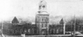
McAden Mill No. 2, 1917
-
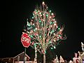
A tree decorated with Christmas lights in McAdenville Town


See also
 In Spanish: McAdenville (Carolina del Norte) para niños
