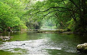
Linville River facts for kids
Quick facts for kids Linville River |
|
|---|---|

Linville River
|
|
|
Location of the mouth of Linville River in North Carolina
|
|
| Country | United States |
| State | North Carolina |
| Counties | Avery, Burke |
| Physical characteristics | |
| Main source | Linville Gap Sugar Mountain, North Carolina 4,051 ft (1,235 m) 36°07′23″N 81°50′44″W / 36.12306°N 81.84556°W |
| River mouth | Catawba River Glen Alpine, North Carolina 1,230 ft (370 m) 35°44′35″N 81°50′11″W / 35.74306°N 81.83639°W |
| Basin features | |
| Progression | Linville → Catawba → Wateree → Santee → Atlantic Ocean |
| River system | Catawba River |
| Tributaries |
|
| Waterfalls | Linville Falls |
The Linville River is a beautiful river located in western North Carolina. It begins high up in the mountains, flowing from places like Peak Mountain and Sugar Mountain. This starting point is known as Linville Gap.
As the river travels south through Avery County, it passes by several small communities. These include Grandfather, Linville, Pineola, and Crossnore. Its journey continues until it reaches the famous Linville Falls.
After the falls, the river enters Burke County. Here, it becomes the main feature of the amazing Linville Gorge. This area is often called "the Grand Canyon of North Carolina" because of its deep and impressive views. The Linville River flows for about 30 miles (48 kilometers). It eventually joins Lake James and the Catawba River.
Linville River: A Special Place
Why the Linville River is Protected
In 1975, North Carolina decided to give a special protection status to about 13 miles (21 kilometers) of the Linville River. This part of the river was named the Linville State Natural River. It became part of the state's Natural and Scenic Rivers System.
This special status helps protect the river's natural beauty and environment. It ensures that the river remains wild and scenic for everyone to enjoy. This protection helps keep the water clean and the surrounding nature healthy.
 | Audre Lorde |
 | John Berry Meachum |
 | Ferdinand Lee Barnett |


