
Linville Falls facts for kids
Quick facts for kids Linville Falls |
|
|---|---|
 |
|
| Lua error in Module:Infobox_mapframe at line 185: attempt to index field 'wikibase' (a nil value). | |
| Location | Blue Ridge Mountains, Burke County, North Carolina |
| Coordinates | 35°56′58″N 81°55′36″W / 35.949572°N 81.926778°W |
| Type | Tiered |
| Total height | 150 ft (46 m) |
| Number of drops | 4 |
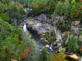
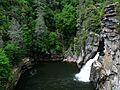
Linville Falls is a beautiful waterfall found in the Blue Ridge Mountains of North Carolina, United States. This amazing waterfall flows down in several steps. It starts with two upper falls, then moves through a small canyon, and finally plunges down a big 45-foot (14 m) drop. The falls are named after the Linville River, which creates them. Linville Falls has the most water flowing over it compared to any other waterfall on the northern side of the Blue Ridge Mountains.
Contents
The Linville River's Journey
Linville Falls marks the beginning of the Linville Gorge. This deep gorge is carved out by the Linville River. After flowing over the falls, the river continues its journey. It eventually ends near a large body of water called Lake James.
A Look Back in Time at Linville Falls
People who work at Linville Falls share stories about its past. They say that local Native American tribes used the falls for important events. It was a very significant place for them.
In 2010, a kayaker named Pat Keller successfully went over the final big drop. Before that, no one was known to have survived such a fall.
There's also a brave rescue story from 1928. A young woman named Hallie L. Hartman fell into the Linville River. She was carried through fast water and then dropped 30 feet over a fall. Charles W. Davis, a 23-year-old beekeeper, bravely saved her. He swam through the rough, cold water to reach her. Even though he was tired, he managed to get her safely to the riverbank.
The falls became part of the National Park Service in 1952. A generous person named John D. Rockefeller, Jr. helped make this happen. He provided money to buy the land. This included about 1,100-acre (4.5 km2) around the falls and part of the Linville Gorge.
Long ago, the upper part of the main falls was as tall as the lower part. But a big flood caused the upper section to collapse. This made the lower falls much longer than before.
Exploring Linville Falls Safely

The National Park Service takes care of Linville Falls. They have a visitor center where you can learn more. There are also several miles of walking trails. These trails are not suitable for wheelchairs. They lead to four different spots where you can get great views of the falls.
The Upper Falls trail is about 0.5-mile (0.80 km) long. It takes you to the very top of the falls. From here, you can see the two small upper falls. You can also watch the water spin through a small canyon before it reaches the main falls.
The Erwin's View trail leads to two amazing viewpoints. The Chimney View overlook is about 0.7 miles away. The Erwin's View overlook is a bit further at 0.8 miles.
Another trail is the Plunge Basin Trail, which is about 0.5-mile (0.80 km) long. This trail leads to the Plunge Basin Overlook. From here, you can see the falls from the other side of the river.
Finally, the Gorge Trail branches off from the Plunge Basin trail. It's about 0.7-mile (1.1 km) long. This path takes you closer to the bottom of the falls.
It's very important to know that swimming is not allowed anywhere at Linville Falls. This rule is in place to keep everyone safe.
Other Waterfalls Nearby
- Duggers Creek Falls is also in the Linville Falls National Recreation Area. You can reach it by a short trail that starts near the visitor center's parking lot. You can see this small waterfall from a footbridge.
- Toms Creek Falls
- Crabtree Falls
Images for kids
-
A closer look at Linville Falls.
-

Panoramic view of Linville Falls and the Linville River from the Chimney Rock overlook.
-

Evening sunset view of Linville Falls from the Chimney Rock overlook.


