Burke County, North Carolina facts for kids
Quick facts for kids
Burke County
|
||
|---|---|---|
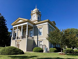
Burke County Courthouse
|
||
|
||
| Motto(s):
"All About Advancing"
|
||
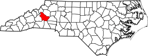
Location within the U.S. state of North Carolina
|
||
 North Carolina's location within the U.S. |
||
| Country | ||
| State | ||
| Founded | 1777 | |
| Named for | Thomas Burke | |
| Seat | Morganton | |
| Largest community | Morganton | |
| Area | ||
| • Total | 514.24 sq mi (1,331.9 km2) | |
| • Land | 506.24 sq mi (1,311.2 km2) | |
| • Water | 8.00 sq mi (20.7 km2) 1.56% | |
| Population
(2020)
|
||
| • Total | 87,570 | |
| • Estimate
(2023)
|
88,338 | |
| • Density | 172.98/sq mi (66.79/km2) | |
| Time zone | UTC−5 (Eastern) | |
| • Summer (DST) | UTC−4 (EDT) | |
| Congressional district | 10th | |
Burke County is a county located in the western part of North Carolina, a state in the United States. A county is like a smaller region within a state, often with its own local government. In 2020, about 87,570 people lived here. The main town and county seat (where the county government is) is Morganton.
Burke County is also part of a larger area called the Metropolitan Statistical Area. This means it's connected to nearby cities like Hickory and Lenoir for things like jobs and services.
Contents
History of Burke County
For thousands of years, different groups of Native Americans lived in this area. Long before Europeans arrived, people from the complex Mississippian culture lived here. They were part of a huge trade network that stretched across North America. They built large earth mounds, and one important site was Joara. This was a big Native American settlement, about 12 acres in size, and it was a regional center for a chiefdom (a group led by a chief). Today, the town of Morganton is located near this ancient site.
Early European Encounters
In 1567, a Spanish explorer named Juan Pardo arrived in the area. His group built a fort called Fort San Juan at Joara. They claimed the land for Spanish Florida, a Spanish colony. Pardo named the settlement "Cuenca" after his hometown in Spain. The Spanish were looking for a land route to silver mines they believed were in central Mexico.
Captain Pardo left about 30 soldiers at Fort San Juan and continued exploring. He built five more forts further west. But in the spring of 1568, the Native Americans attacked Fort San Juan. They killed the soldiers and burned the fort. Almost all the Spanish soldiers at the other five forts were also killed.
Forming the County
Burke County was officially created in 1777, during the American Revolutionary War. It was formed from a part of Rowan County. The county was named after Thomas Burke, who was an important leader at the time. He was a delegate to the Continental Congress and later became the governor of North Carolina. Many Scots-Irish and German immigrants settled in this area in the 1700s. They were mostly independent farmers.
As more people moved in, Burke County was divided several times to create new counties.
- In 1791, parts of Burke and Rutherford County became Buncombe County.
- In 1833, parts of Burke and Buncombe Counties formed Yancey County.
- In 1841, parts of Burke and Wilkes County formed Caldwell County.
- In 1842, more parts of Burke and Rutherford Counties formed McDowell County.
- Finally, in 1861, parts of Burke and several other counties formed Mitchell County.
Revolutionary War and Discoveries
The local soldiers, known as the Burke County Regiment, played a part in the Battle of Kings Mountain. This battle was a key moment in the American Revolution. Frontiersmen from the Appalachian Mountains fought against British forces. These brave militiamen, called the Over Mountain Men, crossed the mountains to surprise the enemy.
For a long time, the detailed story of the 1567 Spanish expedition was not widely known. But in the late 1900s, a record of the expedition was found and translated. In the 1990s, archaeologists started digging at a site they believed was Joara. In 2013, they announced that they had found the remains of Fort San Juan! This discovery changed what we knew about early European attempts to settle in what is now the United States, as the Spanish arrived 40 years before the English settlement at Jamestown, Virginia.
Geography of Burke County
Burke County covers about 514 square miles. Most of this (about 506 square miles) is land, and about 8 square miles is water. The county has parts of two beautiful lakes: Lake James on its western side and Lake Rhodhiss on its northeastern side.
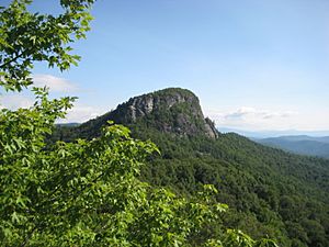
One of the most famous natural landmarks in the county is Table Rock. It's a huge rock formation on a mountain in the Linville Gorge, which is part of the Pisgah National Forest. People often call it "the most visible symbol in the region."
In the southern part of the county, you'll find the South Mountains State Park. This park is almost 21,000 acres and is known for its pretty waterfalls and many hiking trails.
Protected Natural Areas
Burke County is home to parts of several important protected areas:
- Blue Ridge Parkway (a famous scenic road)
- Linville Falls
- Linville Gorge Wilderness
- Pisgah National Forest
There are also state and local protected areas, including:
- Johns River Game Land
- Lake James State Park
- Pisgah National Forest Game Land
- Pisgah (WRC) Game Land
- South Mountains Game Lands
- South Mountains State Park
Major Water Bodies
Many rivers and creeks flow through Burke County, including:
- Canoe Creek
- Catawba River
- Dales Creek
- Drowning Creek
- Hall Creek
- Henry Fork
- Irish Creek
- Jacob Fork
- Lake James
- Lake Rhodhiss
- Linville River
- Little River
- Old Catawba River
- Pearcey Creek
- Rock Creek
- Roses Creek
- Silver Creek
- Upper Creek
Neighboring Counties
Burke County shares borders with these other counties:
- Avery County – to the northwest
- Caldwell County – to the north
- Catawba County – to the east
- Cleveland County – to the south
- Rutherford County – to the south
- McDowell County – to the west
Main Roads and Transportation
 I-40
I-40 US 64
US 64
 US 64 Bus.
 US 70
US 70
 US 70 Bus.
 US 221
 US 321
 NC 18
NC 18 NC 114
 NC 126
 NC 181
 NC 183
The county also has access to two airports:
- Foothills Regional Airport (partially in Caldwell County)
- Hickory Regional Airport (partially in Catawba County)
People of Burke County (Demographics)
| Historical population | |||
|---|---|---|---|
| Census | Pop. | %± | |
| 1790 | 8,106 | — | |
| 1800 | 9,929 | 22.5% | |
| 1810 | 11,007 | 10.9% | |
| 1820 | 13,411 | 21.8% | |
| 1830 | 17,888 | 33.4% | |
| 1840 | 15,799 | −11.7% | |
| 1850 | 7,772 | −50.8% | |
| 1860 | 9,237 | 18.8% | |
| 1870 | 9,777 | 5.8% | |
| 1880 | 12,809 | 31.0% | |
| 1890 | 14,939 | 16.6% | |
| 1900 | 17,699 | 18.5% | |
| 1910 | 21,408 | 21.0% | |
| 1920 | 23,297 | 8.8% | |
| 1930 | 29,410 | 26.2% | |
| 1940 | 38,615 | 31.3% | |
| 1950 | 45,518 | 17.9% | |
| 1960 | 52,701 | 15.8% | |
| 1970 | 60,364 | 14.5% | |
| 1980 | 72,504 | 20.1% | |
| 1990 | 75,744 | 4.5% | |
| 2000 | 89,148 | 17.7% | |
| 2010 | 90,912 | 2.0% | |
| 2020 | 87,570 | −3.7% | |
| 2023 (est.) | 88,338 | −2.8% | |
| U.S. Decennial Census 1790–1960 1900–1990 1990–2000 2010 2020 |
|||
In 2020, the population of Burke County was 87,570 people. There were 36,634 households and 25,391 families living in the county.
Most people in Burke County identify as White (about 78%). Other groups include Black or African American (about 5.4%), Asian (about 3.6%), and Hispanic or Latino (about 8.2%). There are also smaller numbers of Native American and Pacific Islander residents.
Communities in Burke County
City
- Morganton (This is the county seat and the largest community.)
Towns
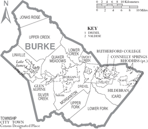
- Connelly Springs
- Drexel
- Glen Alpine
- Hildebran
- Long View
- Rhodhiss
- Rutherford College
- Valdese
Townships
- Drexel
- Icard
- Jonas Ridge
- Linville
- Lovelady
- Lower Creek
- Lower Fork
- Quaker Meadows
- Silver Creek
- Smoky Creek
- Upper Creek
- Upper Fork
- Hildebran
- Connelly Springs
- Rutherford College
- Valdese
Census-Designated Places
These are areas that are like towns but are not officially incorporated as towns.
Unincorporated Communities
These are smaller communities that are not part of any city or town.
- Amherst
- Enola
- Jonas Ridge
- Linville Falls
- Petersburg
- Pleasant Grove
- Sunnyside
Burke County in Popular Culture
Burke County has been featured in books and movies!
- In Jules Verne's novel Master of the World, the villain's secret hideout is thought to be Table Rock Mountain in Burke County, even though the book doesn't say its name directly.
- The outdoor play From This Day Forward has been performed every year in Burke County since 1968. It tells the story of how the town of Valdese was founded.
- Many parts of the 1992 movie Last of the Mohicans were filmed in Burke County. A big fort was even built next to Lake James for the movie! Many local people from Burke and nearby counties were extras in the film, playing settlers, British soldiers, and Native Americans.
- The final scene of the movie The Hunt for Red October used the beautiful scenery of Lake James as its background.
- In 2011, scenes for the movie The Hunger Games were filmed near Hildebran, North Carolina, at the Henry River Mill Village.
See also
 In Spanish: Condado de Burke (Carolina del Norte) para niños
 | Shirley Ann Jackson |
 | Garett Morgan |
 | J. Ernest Wilkins Jr. |
 | Elijah McCoy |


