Rowan County, North Carolina facts for kids
Quick facts for kids
Rowan County
|
|||||
|---|---|---|---|---|---|

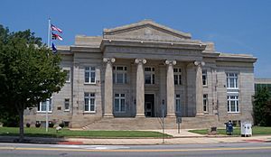
Rowan County Courthouse
|
|||||
|
|||||
| Motto(s):
"Be an original."
|
|||||

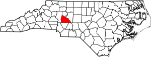
Location within the U.S. state of North Carolina
|
|||||
 North Carolina's location within the U.S. |
|||||
| Country | |||||
| State | |||||
| Founded | April 12, 1753 | ||||
| Named for | Matthew Rowan | ||||
| Seat | Salisbury | ||||
| Largest community | Salisbury | ||||
| Area | |||||
| • Total | 523.95 sq mi (1,357.0 km2) | ||||
| • Land | 511.61 sq mi (1,325.1 km2) | ||||
| • Water | 12.34 sq mi (32.0 km2) 2.36% | ||||
| Population
(2020)
|
|||||
| • Total | 146,875 | ||||
| • Estimate
(2023)
|
151,661 |
||||
| • Density | 280.323/sq mi (108.2331/km2) | ||||
| Time zone | UTC−5 (Eastern) | ||||
| • Summer (DST) | UTC−4 (EDT) | ||||
| Congressional district | 8th | ||||
Rowan County is a county in the state of North Carolina, USA. It was created in 1753 when North Carolina was still a British colony. The county was once very large, stretching far to the west.
Over time, its size became smaller as new counties were formed from its land. Today, Rowan County covers about 524 square miles. In 2020, about 146,875 people lived here. Salisbury is the county seat, which means it's where the county government is located. Salisbury is also the oldest town in western North Carolina that has always been lived in by European-Americans. Rowan County is located northeast of Charlotte. It is part of the larger Charlotte metropolitan area.
Contents
Exploring Rowan County's Past
The first Europeans to visit what is now Rowan County were part of a Spanish trip in 1567. This group was led by Juan Pardo. They built a fort and a mission in a native village called Guatari. This village was likely near the Yadkin River. The Wateree lived there.
A female chief, called Guatari Mico by the Spanish, ruled the area. The Spanish named the village Salamanca and set up a mission. A priest named Sebastián Montero led this mission. The Spanish left the area sometime before 1572.
The county was officially formed in 1753. It was created from the northern part of Anson County. The county was named after Matthew Rowan. He was the acting governor of North Carolina from 1753 to 1754.
Rowan County was originally a huge area with no clear western border. Its size began to shrink in 1770. Parts of Rowan County were used to create other counties. For example, Guilford County, North Carolina was formed in 1770. Surry County, North Carolina was created in 1771.
Later, Burke County, North Carolina was formed in 1777. Iredell County, North Carolina was created in 1788. In 1822, Davidson County, North Carolina was formed from Rowan County's eastern part. Finally, in 1836, the area north of the South Yadkin River became Davie County, North Carolina.
In 2003, Rowan County celebrated its 250th anniversary. This event was called the "250 Fest."
Geography and Natural Features
Rowan County covers a total area of about 524 square miles. Most of this area, about 511 square miles, is land. The remaining 12 square miles (about 2.4%) is water.
The Yadkin River forms the county's eastern border. North of Ellis Crossroads, the South Yadkin River joins the Yadkin River. The South Yadkin River also forms the county's northern border with Davie County.
The southern border of Rowan County is a straight line. This line cuts through the city of Kannapolis.
Neighboring Counties
Rowan County shares its borders with several other counties:
- Cabarrus County to the south
- Davidson County to the east
- Davie County to the north
- Iredell County to the west
- Stanly County to the southeast
Major Roads and Highways
Many important roads pass through Rowan County. These highways help people travel around the county and to other places.
 I-85
I-85 US 29
US 29 US 52
US 52 US 70
US 70 US 601
 NC 8
NC 8 NC 49
NC 49 NC 150
 NC 152
 NC 153
 NC 801
Interstate 85 (I-85) runs through the county from the southwest to the northeast. In the early 2000s, I-85 was made wider in the middle and northern parts of the county. A new bridge over the Yadkin River is also being planned.
U.S. Route 70 enters Rowan County in the northwest. It goes southeast into Salisbury. In Salisbury, it follows Jake Alexander Boulevard and then joins US 29 North as Main Street. US 70 continues northeast through Spencer before entering Davidson County.
U.S. Route 29 forms Main Street in towns like Kannapolis, China Grove, and Landis in the southern part of the county. It joins US 70 as Main Street through Salisbury and Spencer.
U.S. Route 52 is a main road for the southeastern part of the county. It serves towns like Gold Hill, Rockwell, and Granite Quarry. Before reaching downtown Salisbury, US-52 joins Interstate 85. It then follows I-85 into Davidson County.
Population and People
| Historical population | |||
|---|---|---|---|
| Census | Pop. | %± | |
| 1790 | 15,972 | — | |
| 1800 | 20,060 | 25.6% | |
| 1810 | 21,543 | 7.4% | |
| 1820 | 26,009 | 20.7% | |
| 1830 | 20,786 | −20.1% | |
| 1840 | 12,109 | −41.7% | |
| 1850 | 13,870 | 14.5% | |
| 1860 | 14,589 | 5.2% | |
| 1870 | 16,810 | 15.2% | |
| 1880 | 19,965 | 18.8% | |
| 1890 | 24,123 | 20.8% | |
| 1900 | 31,066 | 28.8% | |
| 1910 | 37,521 | 20.8% | |
| 1920 | 44,062 | 17.4% | |
| 1930 | 56,665 | 28.6% | |
| 1940 | 69,206 | 22.1% | |
| 1950 | 75,410 | 9.0% | |
| 1960 | 82,817 | 9.8% | |
| 1970 | 90,035 | 8.7% | |
| 1980 | 99,186 | 10.2% | |
| 1990 | 110,605 | 11.5% | |
| 2000 | 130,340 | 17.8% | |
| 2010 | 138,446 | 6.2% | |
| 2020 | 146,875 | 6.1% | |
| 2023 (est.) | 151,661 | 9.5% | |
| U.S. Decennial Census 1790–1960 1900–1990 1990–2000 2010 2020 |
|||
Population in 2020
In the 2020 United States census, Rowan County had 146,875 people. There were 55,241 households and 37,900 families living in the county.
The people living in Rowan County come from many different backgrounds. Here's a look at the main groups:
| Group | Number | Percentage |
|---|---|---|
| White (not Hispanic) | 100,135 | 68.18% |
| Black or African American (not Hispanic) | 22,730 | 15.48% |
| Native American | 444 | 0.3% |
| Asian | 1,505 | 1.02% |
| Pacific Islander | 71 | 0.05% |
| Other/Mixed | 6,050 | 4.12% |
| Hispanic or Latino | 15,940 | 10.85% |
Population in 2010
In the census of 2010, there were 138,428 people in Rowan County. About 23.80% of the population was under 18 years old. About 14.40% of people were 65 years or older. The average age was 39.1 years.
Education and Learning
Rowan County has many schools and colleges. These places help people of all ages learn and grow.
Colleges and Universities
- Catawba College: Founded in 1851.
- Livingstone College: Founded in 1879.
- Rowan-Cabarrus Community College (RCCC): Started in 1963, offering many different programs.
- Hood Theological Seminary: Founded in 1885, became independent in 2001.
- Campbell University: Has a teaching hospital at Novant Health, Rowan Medical Center, which started in 2014.
Rowan–Salisbury School System
The Rowan–Salisbury School System is a public school district. It serves students from pre-kindergarten to 12th grade. This system covers almost all of Rowan County. In 2009–2010, about 20,887 students attended its 35 schools. This system was formed in 1989 when Rowan County Schools and Salisbury City Schools joined together.
Kannapolis City Schools
Some students in Rowan County live in the city of Kannapolis. Most of Kannapolis is in Cabarrus County. Students in the Rowan County part of Kannapolis go to Kannapolis City Schools. This school system runs separately from the countywide system.
Private Schools
Rowan County also has several private schools:
- North Hills Christian School (for pre-school through high school)
- Rockwell Christian School (for pre-school through high school)
- Sacred Heart Catholic School (for elementary through middle school)
- Salisbury Academy (for pre-kindergarten through middle school)
- Salisbury Adventist School
Libraries for Everyone
The Rowan Public Library system has several locations:
- Headquarters in Salisbury
- East Branch in Rockwell
- Frank T. Tadlock South Rowan Regional Library in China Grove
- West Branch in Cleveland
Local News and Media
The Salisbury Post is the local newspaper for Rowan County. It was started in 1905. The newspaper is published several days each week.
Communities in Rowan County
Rowan County is made up of different types of communities. These include cities, towns, and smaller communities.
Cities
- Kannapolis
- Salisbury (This is the county seat)
Towns
Census-Designated Place
Unincorporated Communities
These are smaller communities that are not officially part of a city or town.
Townships
Townships are smaller areas within the county, often used for local administration.
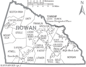
- Atwell
- China Grove
- Cleveland
- Franklin
- Gold Hill
- Litaker
- Locke
- Morgan
- Mount Ulla
- Providence
- Salisbury
- Scotch Irish
- Steele
- Unity
Famous People from Rowan County
Many notable people have connections to Rowan County. Here are a few:
- Tommy Barnhardt (born 1963): An NFL football player.
- William Lee Davidson (1746–1781): A colonel during the American Revolutionary War.
- Joseph Dickson (1745–1825): A colonel in the American Revolutionary War and a Congressman.
- John Willis Ellis (1820–1861): A former governor of North Carolina. He was born in what was then eastern Rowan County.
- Jackie Fargo (1930–2013): A professional wrestler.
- James Allen Graham (1921–2003): A former North Carolina Commissioner of Agriculture.
- Phil Kirk (born 1944): A former chairman of the North Carolina State Board of Education.
- Francis Locke (1722–1796): A plantation owner known for his victory at the Battle of Ramseur's Mill during the American Revolutionary War.
- Francis Locke, Jr. (1766–1823): A congressman.
- Matthew Locke (1730–1801): A congressman and a Brigadier General in the American Revolution.
- W. Eugene McCombs (1925–2004): A politician and former Rowan County Commissioner.
- Lee Slater Overman (1854–1930): A former U.S. Senator for North Carolina.
- Joseph Pearson (1776–1834): A congressman.
- Griffith Rutherford (1721–1805): A military officer and general in the Revolutionary War.
See also
 In Spanish: Condado de Rowan (Carolina del Norte) para niños
 | Calvin Brent |
 | Walter T. Bailey |
 | Martha Cassell Thompson |
 | Alberta Jeannette Cassell |


