Yadkin River facts for kids
Quick facts for kids Yadkin River |
|
|---|---|

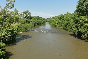
The Yadkin River at Elkin, North Carolina, in 2011.
|
|

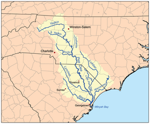
The Yadkin River is the northernmost part of the Pee Dee Drainage Basin.
|
|
| Country | United States |
| State | North Carolina |
| Physical characteristics | |
| Main source | Watauga County near Blowing Rock 36°08′39″N 81°37′45″W / 36.1442958°N 81.6292711°W |
| River mouth | Confluence with the Uwharrie River, forming the Pee Dee River 4 miles (6.4 km) southeast of Badin 35°22′51″N 80°03′35″W / 35.3806969°N 80.0597749°W |
| Basin features | |
| Progression | Yadkin River → Pee Dee River → Atlantic Ocean |
| River system | Yadkin–Pee Dee River Basin |
| Waterbodies | W. Kerr Scott Reservoir, High Rock Lake, Tuckertown Reservoir, Badin Lake, Falls Reservoir |
| GNIS | 1024415 |
The Yadkin River is one of the longest rivers in North Carolina. It flows for about 215 miles (346 km). The river starts in the northwestern part of the state. This is near the Blue Ridge Parkway's Thunder Hill Overlook.
Many dams are built on the river. These dams help control floods. They also provide water and create power. The Yadkin River becomes the Pee Dee River when it joins the Uwharrie River. This meeting point is south of Badin. The river then flows into South Carolina. The entire Yadkin River and Great Pee Dee River are part of the Yadkin–Pee Dee River Basin.
Contents
What's in a Name? The Yadkin River's Meaning
The name Yadkin comes from a Siouan Indian word, Yattken. We don't know its exact meaning. Some people think it might mean "big tree" or "place of big trees."
The river has had other names too:
- Adkin River
- Atkin River
- Big Yadkin River
- Reatkin River
- Sapona River
- Yatkin River
Yadkin County, North Carolina and its main town, Yadkinville, are named after this river.
A Look Back: History of the Yadkin River Area
Before Europeans arrived, Siouan-speaking tribes lived in the Yadkin River area. The Saura and Tutelo tribes are two groups mentioned in old records.
Before the American Revolution, settlers from Europe moved here. Many were from Germany, England, and Scotland and Ireland. They traveled from Virginia and Pennsylvania using old roads. One famous group was the Moravian colonists. They bought a large area called Wachovia in 1753. You can still visit Old Salem today, which was part of this settlement.
In 1859, the North Carolina Supreme Court made an important decision. They said that parts of the Yadkin Riverbed could be owned by private people. This meant that if someone built a dam, their property could not be taken without fair payment.
Fun on the River: Recreation and Activities
The Yadkin River is a great place for outdoor fun!
Fishing and Boating
Many people enjoy fishing here. You can catch different kinds of sunfish, catfish, largemouth bass, and white bass. Spring and early summer are the best times for white bass.
You can also go canoeing and rafting on the river. It's a wonderful way to see nature.
Parks Along the River
A part of the river flows through Pilot Mountain State Park. This park is known for its unique mountain. Morrow Mountain State Park and the Uwharrie National Forest are also along the river's banks. This is where the Yadkin River changes its name to the Pee Dee River.
Yadkin River State Trail: A Water Adventure
In 1985, North Carolina created the Yadkin River State Trail. This is a special paddle trail for canoes and kayaks. It follows the river for about 130 miles (209 km).
This trail is part of the North Carolina State Trails System. It's managed by the NC Division of Parks and Recreation. Along the trail, you'll find places to launch your boat and spots for camping.
River Branches: Yadkin River's Tributaries
The Yadkin River has many smaller rivers and streams that flow into it. These are called tributaries. Some of the main ones include:
Water for Everyone: Supply and Lakes
The Yadkin-Pee Dee River Basin provides water for many towns. These towns are in both North and South Carolina. Sometimes, during dry years, there isn't enough water for everyone. This can lead to disagreements about how to share the water.
Lakes Created by Dams on the Yadkin River
Many lakes, called reservoirs, have been created by building dams on the Yadkin and Pee Dee rivers in North Carolina. Here are some of them, listed from upstream (closer to the source) to downstream (closer to the mouth):
- W. Kerr Scott Reservoir
- High Rock Lake
- Tuckertown Reservoir
- Badin Lake
- Falls Reservoir
- Lake Tillery
- Blewitt Falls Lake
Most of these lakes help create hydroelectric power. This is electricity made from the force of moving water. For a long time, a company called Alcoa managed the dams at High Rock, Tuckertown, Badin, and Falls. In 2016, a new company, Cube Hydro Carolinas, took over. They have a license to operate the dams until 2055. This license requires them to keep a certain water level in the lakes and have a swimming beach at High Rock Lake.
Crossing the River: Bridges and Roads
Many roads and bridges cross the Yadkin River. Here are some of the main crossings:
Caldwell County
- Many smaller crossings in the upper part of the river
- Multiple crossings of
 NC 268 (Yadkin River Road)
 - Grandin Road
Wilkes County
 NC 268 in Ferguson
- Browns Ford Road below the W. Kerr Scott Dam
 US 421 in Wilkesboro
- Curtis Bridge Road in Wilkesboro
- Wilkesboro Avenue (
 NC 18) in Wilkesboro
 - US 421 Business
- Red White and Blue Road in Roaring River
- Clingman Road in Ronda
Surry County and Yadkin County
- South Bridge Street and South Gwyn Avenue (US 21 Business) connecting Elkin and Jonesville
 I-77
I-77 US 601 in Crutchfield
- Richmond Hill Church Road
- Crossing in Siloam
Yadkin County and Forsyth County
 NC 67
NC 67- Old US 421
 US 421
Davie County and Forsyth County
 I-40 between Bermuda Run and Clemmons
 US 158 between Bermuda Run and Clemmons
Davie County and Davidson County
 US 64
US 64
Rowan County and Davidson County
 | Bayard Rustin |
 | Jeannette Carter |
 | Jeremiah A. Brown |

