Guilford County, North Carolina facts for kids
Quick facts for kids
Guilford County
|
|||
|---|---|---|---|
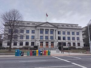
Old Guilford County Courthouse in Greensboro
|
|||
|
|||
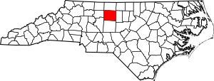
Location within the U.S. state of North Carolina
|
|||
 North Carolina's location within the U.S. |
|||
| Country | |||
| State | |||
| Founded | 1771 | ||
| Named for | Francis North, 1st Earl of Guilford | ||
| Seat | Greensboro (courthouse also located in High Point) |
||
| Largest community | Greensboro | ||
| Area | |||
| • Total | 657.63 sq mi (1,703.3 km2) | ||
| • Land | 645.92 sq mi (1,672.9 km2) | ||
| • Water | 11.71 sq mi (30.3 km2) 1.78% | ||
| Population
(2020)
|
|||
| • Total | 541,299 | ||
| • Estimate
(2023)
|
549,866 | ||
| • Density | 838.03/sq mi (323.57/km2) | ||
| Time zone | UTC−5 (Eastern) | ||
| • Summer (DST) | UTC−4 (EDT) | ||
| Congressional district | 6th | ||
Guilford County is a county in North Carolina, a state in the United States. In 2020, about 541,299 people lived here. This makes it the third-largest county in North Carolina by population.
The main city and biggest community is Greensboro. Since 1938, there has also been a county court in High Point. Guilford County was created in 1771. It is part of a larger area called the Greensboro-High Point Metropolitan Statistical Area.
Contents
History of Guilford County
When Europeans first arrived, the Cheraw people lived in the area. They spoke a Siouan language. In the 1740s, settlers came looking for good land. These early settlers included American Quakers and German Reformed and Lutherans. There were also British Quakers and Scotch-Irish Presbyterians.
In 1771, North Carolina's government created Guilford County. It was made from parts of Rowan and Orange counties. The county was named after Francis North, 1st Earl of Guilford. He was the father of Frederick North, Lord North, who was the British Prime Minister.
Early Churches and Communities
Friedens Church, which means "peace" in German, is in eastern Guilford County. It was started by early European settlers. A Lutheran group built a log church here in 1745. This church was used for 25 years. Later, a bigger building was finished around 1771.
The Quaker community also played a big role in settling the county. Many Quakers still live in Guilford County today. New Garden Friends Meeting, started in 1754, is still active in Greensboro.
Alamance Presbyterian Church was built in 1762. Its congregation officially began in 1764. It has been on the same site in Greensboro ever since.
The American Revolution
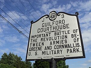
On March 15, 1781, a major battle happened here. It was the Battle of Guilford Court House. This battle was part of the American Revolution. American forces led by General Nathanael Greene fought British forces under General Charles Cornwallis.
The British won the battlefield, but they lost many soldiers. Cornwallis decided to move his army to the coast. This battle was a turning point in the war in the South. It eventually led to Cornwallis's surrender at Yorktown, Virginia.
After the war, in 1779, the southern part of Guilford County became Randolph County. In 1785, the northern part became Rockingham County.
In 1808, Greensboro became the new county seat. It replaced the small town of Guilford Court House. Greensboro was chosen because it was more central for travelers.
Industrial Growth and Social Change
Guilford County was an early center for industry. The Mt. Hecla Cotton Mill opened in 1818. It was one of the first cotton mills in North Carolina. It later used steam power, which was very new at the time.
Before the Civil War, many people in the county were against slavery. These included Lutherans, Quakers, and Methodists. The county was a stop on the Underground Railroad. This was a secret network that helped enslaved people escape to freedom in the North. Levi Coffin, a Guilford County native, was a key leader of the "railroad." He helped more than 2,000 enslaved people escape.
Higher Education
Guilford County is home to several important colleges:
- Guilford College started in 1837 as a boarding school. It is one of the oldest colleges in the country where both men and women could study together.
- Greensboro College was founded in 1838 by the Methodist Church. It was one of the first colleges for women in the U.S. It became coeducational in 1954.
- Bennett College began in 1873 for African American students. In 1926, it became a college only for women.
- North Carolina Agricultural and Technical State University was founded in 1891. It was created as a land-grant college for African Americans. It was the first state-supported school for people of color in North Carolina.
- The University of North Carolina at Greensboro also started in 1891. It was the state's first public college for women. It trained teachers. In 1963, it became a coed university.
Civil Rights Movement
In 1960, North Carolina still had laws that separated people by race. Four African American students from North Carolina A&T State University in Greensboro started a famous sit-in. These students, known as the Greensboro Four, sat at a "whites-only" lunch counter. They asked to be served after buying items in the store.
When they were refused, they asked why their money was good for shopping but not for food. They were arrested, but their actions inspired many other students. Both Black and white students joined the sit-ins. Within two months, the movement spread to 54 cities in nine states. Eventually, Woolworth's and other restaurants ended their racial separation policies.
Later, in 1979, a sad event happened in Greensboro. Groups promoting hate attacked a march for civil rights. Five people were killed. In 1985, the families of the victims won a civil lawsuit. They showed that the city police had not protected the marchers. This led to changes and a focus on justice.
Geography
Guilford County covers about 657.63 square miles. Most of this area is land, about 645.92 square miles. The rest, about 11.71 square miles, is water.
The county has several rivers, including the Deep and Haw rivers.
Protected Areas
- Guilford Courthouse National Military Park
- Cascades Preserve (part)
- Charlotte Hawkins Brown Museum
- Company Mill Preserve
- Greensboro Arboretum
- Haw River State Park (part)
- Piedmont Environmental Center
- Rich Fork Preserve (part)
Major Water Bodies
- Back Creek
- Beaver Creek
- Belews Lake
- Big Alamance Creek
- Buffalo Creek
- Buffalo Lake
- Deep River
- Haw River
- Hickory Creek
- Lake Brandt
- Lake Hggins
- Lake High Point
- Lake Mackintosh
- Lake Townsend
- Little Alamance Creek
- Mears Fork
- Moores Creek
- North Buffalo Creek
- Old Hollow Lake
- Reddicks Creek
- Reedy Fork
- Rock Creek
- South Buffalo Creek
- West Fork Deep River
Neighboring Counties
- Rockingham County – north
- Alamance County – east
- Randolph County – south
- Davidson County – southwest
- Forsyth County – west
- Stokes County – northwest
Main Roads
 I-40
I-40 I-85
I-85 I-73
I-73 I-74
I-74 I-85
I-85


 Future I-685


 I-785 / Future I-785
 I-840
I-840 US 29
US 29 US 70
US 70 US 158
 US 220
 US 421
 NC 22
NC 22 NC 61
NC 61 NC 62
NC 62 NC 65
NC 65 NC 68
NC 68 NC 100
 NC 150
Important Transportation Hubs
- Amtrak Thruway (High Point Station)
- High Point Station
- J. Douglas Galyon Depot (Greensboro Station)
- Piedmont Triad International Airport
Population Data
| Historical population | |||
|---|---|---|---|
| Census | Pop. | %± | |
| 1790 | 7,300 | — | |
| 1800 | 9,442 | 29.3% | |
| 1810 | 11,420 | 20.9% | |
| 1820 | 14,511 | 27.1% | |
| 1830 | 18,737 | 29.1% | |
| 1840 | 19,175 | 2.3% | |
| 1850 | 19,754 | 3.0% | |
| 1860 | 20,056 | 1.5% | |
| 1870 | 21,736 | 8.4% | |
| 1880 | 23,585 | 8.5% | |
| 1890 | 28,052 | 18.9% | |
| 1900 | 39,074 | 39.3% | |
| 1910 | 60,497 | 54.8% | |
| 1920 | 79,272 | 31.0% | |
| 1930 | 133,010 | 67.8% | |
| 1940 | 153,916 | 15.7% | |
| 1950 | 191,057 | 24.1% | |
| 1960 | 246,520 | 29.0% | |
| 1970 | 288,590 | 17.1% | |
| 1980 | 317,154 | 9.9% | |
| 1990 | 347,420 | 9.5% | |
| 2000 | 421,048 | 21.2% | |
| 2010 | 488,406 | 16.0% | |
| 2020 | 541,299 | 10.8% | |
| 2023 (est.) | 549,866 | 12.6% | |
| U.S. Decennial Census 1790-1960 1900–1990 1990–2000 2010 2020 |
|||
2020 Census Information
| Race | Number | Percentage |
|---|---|---|
| White (not Hispanic) | 255,640 | 47.23% |
| Black or African American (not Hispanic) | 179,423 | 33.15% |
| Native American | 1,918 | 0.35% |
| Asian | 28,719 | 5.31% |
| Pacific Islander | 216 | 0.04% |
| Other/Mixed | 23,231 | 4.29% |
| Hispanic or Latino | 52,152 | 9.63% |
In 2020, there were 541,299 people living in Guilford County. There were 206,950 households and 132,323 families.
2010 Census Information
In 2010, the county had 500,879 people. About 63% of households owned their homes. The population density was about 648 people per square mile.
The population was made up of different groups. About 64.53% were White. About 29.27% were Black or African American. About 2.44% were Asian. About 3.80% of the population was Hispanic or Latino.
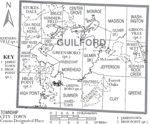
Communities in Guilford County
Cities
- Archdale (part)
- Burlington (part)
- Greensboro (county seat and largest community)
- High Point (part)
Towns
- Gibsonville (part)
- Jamestown
- Kernersville (part)
- Oak Ridge
- Pleasant Garden
- Sedalia
- Stokesdale (part)
- Summerfield
- Whitsett
Townships
- Bruce
- Center Grove
- Clay
- Deep River
- Fentress
- Friendship
- Gilmer
- Greene
- Jefferson
- Madison
- Monroe
- Morehead
- Rock Creek
- Sumner
- Washington
Census-Designated Places
Unincorporated Communities
- Browns Summit
- Climax
- Colfax
- Julian
- Monticello
- Ellisboro
- Gibsonville
- Guilford
- Kimesville
- Ossipee
Notable People from Guilford County
- Joseph Cannon: He was the 35th speaker of the United States House of Representatives.
- Mike Causey: He is the 11th Commissioner of Insurance of North Carolina.
- Levi Coffin: An important leader against slavery. He was called the "President of the Underground Railroad" for helping enslaved people escape.
- Dolley Madison: The wife of President James Madison and the fourth First Lady of the United States.
- Edward R. Murrow: A famous American broadcast journalist.
- William Sydney Porter: A short-story writer known as "O. Henry". His story "The Ransom of Red Chief" is very famous.
- Ryan Wesley Routh: Known for an alleged attempt on a former president.
See also
 In Spanish: Condado de Guilford para niños
 | Mary Eliza Mahoney |
 | Susie King Taylor |
 | Ida Gray |
 | Eliza Ann Grier |


