
Haw River facts for kids


The Haw River is a long river in north central North Carolina, United States. It flows for about 110 miles (177 km). The river is a major branch of the Cape Fear River.
An English explorer named John Lawson first wrote about the "Hau River" in his 1709 book. The name "Haw" comes from "Saxapahaw." This word means "piedmont" or "foothill" in the Catawban language. A small town called Haw River is named after the river.
Contents
Journey of the Haw River
The Haw River starts in the Piedmont area of North Carolina. This is in the northeast part of Forsyth County, near Kernersville.
Flowing Through Counties
The river first flows northeast. It passes north of Oak Ridge and Summerfield. Then it enters Rockingham County and goes through Haw River State Park. After that, it turns southeast.
As it continues, the Haw River flows through a corner of Guilford County. Then it enters Alamance County. Here, it passes through places like Ossipee and the town of Haw River.
The river is joined by Great Alamance Creek at Swepsonville. It then flows to Saxapahaw. The Haw River also forms the border for Orange County and Chatham County.
Reaching Jordan Lake
The Haw River keeps flowing southeast into Chatham County. It passes north of Pittsboro. About 12 miles (19 km) southeast of Alamance County, the Haw River flows into the Jordan Lake reservoir. This large lake is formed where the Haw River meets New Hope Creek.
Finally, about 4 miles (6 km) south of the Jordan Lake dam, the Haw River joins the Deep River. Together, they form the start of the Cape Fear River.
Amazing Wildlife of the Haw River
The Haw River is a home for many different kinds of animals. You can find blue herons flying overhead. Beavers and otters swim in the water. Deer often come to the riverbanks. Many fish, like bluegill bream, live in its waters. These are just a few of the wild animals that make the Haw River their home!
Haw River History and Its Impact
The Haw River has always been important to the people living near it. Long ago, Native American groups, like the Sissipahau Indians, lived along its banks. The river helped their communities grow.
Mills and Industry
In the 1850s, the river was first dammed in Saxapahaw. This was done to power textile mills. These mills made cloth and were very important through the 1800s and 1900s. They helped Alamance County rebuild its economy after the American Civil War. A famous cloth called Alamance Plaids was even developed near Glencoe.
Pollution and Cleanup Efforts
During the 1900s, the river became very polluted. Chemicals from the textile factories harmed the water. Luckily, as industries changed, pollution in the Haw River has gone down.
However, the river still faces challenges. Runoff from suburban areas and sediment can still cause pollution. Many groups, local governments, and businesses are working together to clean up and protect the Haw River. New rules, like the Jordan Lake Rules, are helping to prevent future pollution. Most parts of the Haw River are now clean enough for fun activities and as a source of drinking water.
Local and state governments work hard to prevent pollution. For example, the Durham Wastewater Treatment Plant helps keep Jordan Lake clean. Even if nutrient levels rise in some shallow parts of the lake, they usually return to normal quickly.
Economy and Recreation on the Haw River

For over a hundred years, factories and other businesses built North Carolina's economy. Many of them were located along the Haw River. They provided jobs and helped communities grow. Today, some mills still operate near the Haw River, like Copland Mills in Burlington, NC.
The Haw River also provides drinking water for many people in North Carolina. About 10% of the state's population lives in the Haw River Watershed. This means they rely on the river for their water. The river is also a great place for fun outdoor activities. Many groups and government agencies are working to protect and develop the Haw River for everyone.
Farming and Trails
Farming has always been a key part of the economy in the rural areas along the Haw River. Farmers grow crops and raise animals like poultry and beef. This helps provide food for the country.
To help protect the river and offer more ways to enjoy it, several trails have been created.
- The Haw River Trail is a special project started in 2006. It will have both a walking trail and a paddling trail. These trails will connect Haw River State Park and Jordan Lake State Recreation Area. This trail is also part of the larger Mountains-to-Sea Trail in North Carolina.
- Another exciting trail is the Haw River Wine Trail. The Haw River Valley has become known for growing grapes. This trail started with five wineries in Guilford and Alamance Counties. Today, four wineries are open on the trail, and they have all made award-winning wines!
Parks and Golf Courses
The State of North Carolina has created a state park on the Haw River. Many city and county parks are also located along the river. You can find golf courses too, like Greensboro National Golf Club and Indian Valley Golf Course. These places offer great ways to enjoy the beauty of the Haw River.
Cities and Towns Along the Haw River

Many communities have grown up along the Haw River. Here are some of them:
- In Chatham County:
- In Alamance County:
* Saxapahaw * Swepsonville * Graham * Haw River * Burlington * Carolina * Glencoe * Ossipee * Altamahaw
- In Guilford County:
- In Forsyth County:
* The Haw River begins near Kernersville.
Dams on the Haw River

Over time, many dams have been built on the Haw River. These dams helped power mills, water crops, and provide drinking water. Some parts of old dams can still be seen today.
Here are some of the dams that are still standing on the Haw River:
- B. Everett Jordan Dam - 113 feet (34 m) tall
- Bynum Dam - 8 feet (2.4 m) tall
- Saxapahaw Dam - 30 feet (9.1 m) tall
- Puryear Dam - 10 feet (3.0 m) tall
- Old Swepsonville Dam - 5 feet (1.5 m) tall
- Glencoe Mills Dam - 10 feet (3.0 m) tall
- Indian Valley Dam
- Altamahaw Dam - 8 feet (2.4 m) tall
(Note: The Granite Mills Dam was removed in 2016.)
Images for kids
-
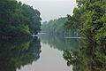
Convergence of the Haw River and Great Alamance Creek in Swepsonville, NC
-
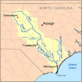
Map of the Cape Fear drainage basin showing Haw River
