Rockingham County, North Carolina facts for kids
Quick facts for kids
Rockingham County
|
|||
|---|---|---|---|
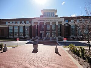
Rockingham County Courthouse in Wentworth
|
|||
|
|||
| Nickname(s):
North Carolina's North Star
|
|||
| Motto(s):
"You're in a good place"
|
|||
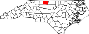
Location within the U.S. state of North Carolina
|
|||
 North Carolina's location within the U.S. |
|||
| Country | |||
| State | |||
| Founded | 1785 | ||
| Named for | Charles Watson-Wentworth, 2nd Marquess of Rockingham | ||
| Seat | Wentworth | ||
| Largest community | Eden | ||
| Area | |||
| • Total | 572.76 sq mi (1,483.4 km2) | ||
| • Land | 565.64 sq mi (1,465.0 km2) | ||
| • Water | 7.12 sq mi (18.4 km2) 1.24% | ||
| Population
(2020)
|
|||
| • Total | 91,096 | ||
| • Estimate
(2023)
|
92,518 | ||
| • Density | 161.05/sq mi (62.18/km2) | ||
| Time zone | UTC−5 (Eastern) | ||
| • Summer (DST) | UTC−4 (EDT) | ||
| Congressional district | 6th | ||
Rockingham County is a county in North Carolina, USA. In 2020, about 91,096 people lived here. Its main town, where the county government is, is Wentworth. People often call Rockingham County "North Carolina's North Star."
Contents
History of Rockingham County
Early Settlers and Founding
Long ago, before Europeans arrived, the Cheraw/Saura Native American people lived in the area that is now Rockingham County. They had small villages along the Dan River. Around 1710, they moved south to South Carolina.
Between 1728 and 1733, a man named William Byrd II explored the Dan River Valley. He was helping to map the border between North Carolina and Virginia. He bought a large piece of land, about 20,000 acres. He called it the "Land of Eden" to encourage farmers to move there.
The first white settlers came from other states like Pennsylvania, New Jersey, Maryland, and Virginia. They were from German, English, Scottish, and Irish families. Some were wealthy, but most were poor farmers. During the American Revolutionary War, some local men joined militias to fight. American and British troops even passed through the area in 1781.
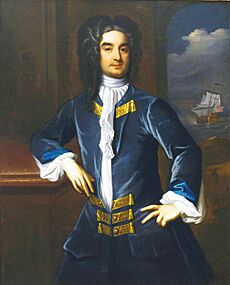
The North Carolina General Assembly created Rockingham County on December 29, 1785. It was formed from the northern part of Guilford County. The county was named after Charles Watson-Wentworth, 2nd Marquess of Rockingham. He was the British Prime Minister twice. He helped get rid of the Stamp Act in 1766. More settlers, many from Scotland and Ireland, continued to arrive until 1800.
Rockingham County's first court meeting was held in February 1786. A wooden courthouse was built the next year, and a community called Rockingham Courthouse grew around it. In 1798, this community was renamed Wentworth. A new brick courthouse was built in 1824. Wentworth stayed a small town, mostly focused on government business. Another town, Leaksville, was started in 1795 to be a trading center.
Before the Civil War and During the War
In the early 1800s, Rockingham County's economy was mostly small farms. Farmers grew food for themselves, and tobacco was the main crop they sold. After 1812, the economy started to change. In 1813, John Motley Morehead built the county's first cotton mill in Leaksville.
By 1831, Leaksville had an oil mill, a sawmill, and a cotton gin. Still, tobacco was the most important part of the economy for most of the 1800s. Towns like Madison, Leaksville, and Reidsville were market towns where farmers sold their tobacco. North Carolina's first public school opened in Rockingham County in 1840.
Slavery slowly grew in the county as tobacco farming expanded. By the 1860s, about 37 percent of the people in the county were enslaved.
When the American Civil War started in 1861, some men from Rockingham County joined the Confederate States Army. Local men formed several military groups to fight in the war. A local gun factory, Searcy & Moore, made weapons for the Confederate forces. Some soldiers who left the army hid in the county. A railroad was built to connect Reidsville with Danville and Greensboro in 1864. The war ended in 1865 with the defeat of the Confederacy.
After the Civil War and New Industries
After the Civil War, the economy in Rockingham County was very weak. There were few cattle, and freeing enslaved people greatly affected large farms. A reporter in 1865 said that food and places to stay were hard to find.
After the war, Reidsville quickly grew as a center for making tobacco products. This was helped by the railroad built during the war. Leaksville became a town in 1874. The town of Stoneville also grew from a trading spot and became a town in 1877. Railroad service reached Madison in the 1880s.
More factories, especially for making cloth (textiles), opened in the late 1800s. This caused towns to grow. In 1895, the Mayo Mills were built near Madison. A community quickly grew around the factory and became the town of Mayodan in 1899. Another mill was built in what became the town of Avalon in 1899. The Avalon Mill was the largest textile factory in North Carolina at the time. It burned down in 1911. By 1920, all the textile factories in the area were part of Washington Mills in Mayodan.
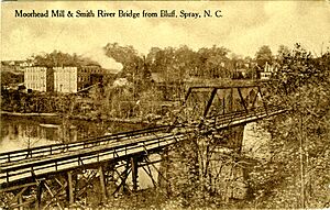
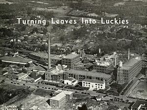
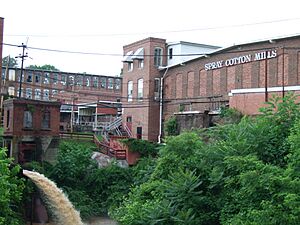
Meanwhile, James Turner Morehead took over his family's businesses in Leaksville in 1866. He worked to expand industry there. He helped build new railroads. By the 1890s, his textile businesses were grouped into two companies. His son-in-law, Frank Mebane, took them over. Between 1898 and 1906, Mebane built six new cotton mills. This led to the growth of two new mill towns near Leaksville: Spray and Draper. These three towns were known as the "Tri-Cities."
The 1900s
In October 1906, the county courthouse in Wentworth burned down. For years, people in Reidsville wanted the county government moved to their city. Others in the county did not agree. The county leaders decided to rebuild the courthouse in Wentworth. The new building was finished in 1908.
The Penn Brothers Tobacco Company factory in Reidsville became part of the American Tobacco Company in 1911. This factory became Reidsville's most important business. It paid good wages and employed 2,000 workers in the 1940s and 1950s.
Draper became a town in 1949, and Spray became a town two years later. In September 1967, Leaksville, Draper, and Spray joined together to form the new city of Eden. Eden then became the largest city in the county. In 1978, Miller Brewing Company opened a large brewery in Eden. It became a major employer with high-paying jobs.
Economic Changes
The textile industry faced challenges in the 1980s and 1990s. Many factories closed. For example, the Washington Mills plant in Mayodan closed in 1999. Other textile companies also closed their plants in Eden. This caused many people to lose their jobs. Some workers moved to bigger cities to find new jobs.
In March 1998, a strong tornado hit Rockingham County. It damaged homes and a textile mill in Mayodan. It also destroyed buildings in Stoneville and caused two deaths.
After the textile factories closed, the Miller brewery in Eden was the main industry. But it also announced its closure in 2015. The loss of these big employers hurt local stores, and many closed. The American Tobacco Company factory in Reidsville also closed in early 2020.
The 2000s
In 2011, a new courthouse, the Rockingham County Justice Center, opened in Wentworth. The old courthouse became a museum and historical archive.
In February 2014, a coal ash pond at Duke Power's Dan River Steam Station in Eden spilled into the Dan River.
Geography
Rockingham County covers about 572.76 square miles. Most of it is land (565.64 square miles), and a small part is water (7.12 square miles). It shares borders with several counties in North Carolina and Virginia. The soil in much of the county is sandy.
The county is located in the foothills of the Blue Ridge Mountains. It is part of the Piedmont Triad region.
Four main rivers flow through Rockingham County. The Dan, Mayo, and Smith Rivers are in the northwestern part. They flow into the Roanoke River. The Haw River is in the southeastern part and flows into the Cape Fear River. There are also several creeks and two major lakes: Belews Lake and Lake Reidsville.
Nature Areas
Rockingham County has several protected natural areas and parks:
- Courtland Park and Bird Sanctuary
- Dan River Game Land
- Haw River State Park (part of it)
- Knight Brown Nature Preserve
- Mayo River State Park
- Woodland Community Park
People of Rockingham County
2020 Census Information
| Race | Number | Percentage |
|---|---|---|
| White (not Hispanic) | 64,218 | 70.49% |
| Black or African American (not Hispanic) | 16,611 | 18.23% |
| Native American | 282 | 0.31% |
| Asian | 493 | 0.54% |
| Pacific Islander | 29 | 0.03% |
| Other/Mixed | 3,377 | 3.71% |
| Hispanic or Latino | 6,086 | 6.68% |
In 2020, there were 91,096 people living in the county. These people lived in 38,462 households, with 25,717 being families. Rockingham County is part of the larger Greensboro-High Point area.
Population Changes Over Time
|
||||||||||||||||||||||||||||||||||||||||||||||||||||||||||||||||||||||||||||||||||||||||||||||||||||||||||||||||
The number of people living in Rockingham County has not changed much since the 1980s. Experts believe the population will grow slower here than in other parts of North Carolina.
Economy
For a long time, Rockingham County's economy depended on making textiles (cloth) and tobacco products. Textile factories were mostly in the northern part of the county around Eden. Tobacco was more common in the south, especially near Reidsville. When these industries declined in the 1990s, it hurt the county's economy.
Recently, the county has seen growth in tourism, new manufacturing, and small businesses. Some big employers in the county include government offices, hospitals, textile makers like Unifi and Gildan Yarns, the gun maker Sturm, Ruger & Co., and Walmart.
About 18 percent of people in Rockingham County live in poverty. This is higher than the average for North Carolina and the whole country. In 2023, the county was rated as "economically distressed."
Transportation
Rockingham County has several major highways that help people travel: U.S. Route 220/Interstate 73, U.S. Route 158, U.S. Route 29/Interstate 785, and U.S. Route 311. Trains also run through Eden, Reidsville, Stoneville, Madison, and Mayodan. For air travel, there is the Rockingham County NC Shiloh Airport.
Main Highways


 I-73 / Future I-73


 Future I-785
 US 29
US 29
 US 29 Bus.
 US 158
 US 220
 US 311
 NC 14
NC 14 NC 65
NC 65 NC 68
NC 68 NC 87
NC 87 NC 135
 NC 150
 NC 700
 NC 704
 NC 770
Education
Public schools in Rockingham County are run by Rockingham County Schools. They have 12 elementary schools, four middle schools, four high schools, an early college high school, and an alternative school. The school system is managed by a school board.
There is also Rockingham Community College in Wentworth. About 14.5 percent of adults in the county have a college degree or higher education.
Healthcare
Rockingham County has two hospitals: Annie Penn Hospital in Reidsville and UNC Rockingham Health Care in Eden. About 11.2 percent of people in the county do not have health insurance. A 2023 report found that Rockingham County residents were less healthy than most of the state. They had higher rates of adult smoking, obesity, and other health issues.
Culture and Attractions
Rockingham County offers many fun places to visit. You can explore the state parks along the Dan and Mayo rivers near Mayodan. The historic downtown areas of Leaksville, Draper, and Spray (now part of Eden) are also interesting.
Other attractions include:
- The Chinqua-Penn Plantation in Reidsville
- The Deep Springs Plantation in Stoneville
- High Rock Farm in Williamsburg
- Mulberry Island Plantation in Stoneville
- The historic Penn House in Reidsville
- Lake Reidsville, a popular spot in the Reidsville area.
You can also find various historic shops around the county.
The Museum & Archives of Rockingham County (the MARC) is the county's only historical museum. It is located in the Rockingham County Courthouse in Wentworth. The museum has exhibits and items about Rockingham County's history. You can also see the restored 1816 Wright Tavern and the 1910 Old Jail nearby.
In the early 1900s, textile workers in Rockingham created a lot of old-time music. Hunting has also been a popular activity in the county for a long time.
Communities
Towns and Cities
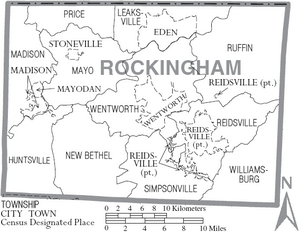
- Eden (the biggest community)
- Reidsville
- Madison
- Mayodan
- Stokesdale (mostly in Guilford County)
- Stoneville
- Wentworth (where the county government is)
Township Areas
- Huntsville
- Leaksville
- Madison
- Mayo
- New Bethel
- Price
- Reidsville
- Ruffin
- Simpsonville
- Stoneville
- Wentworth
- Williamsburg
Census-Designated Place
Other Communities
- Bethany
- Monroeton
- Oregon Hill
- Price
- Providence
See also
 In Spanish: Condado de Rockingham (Carolina del Norte) para niños
 | Delilah Pierce |
 | Gordon Parks |
 | Augusta Savage |
 | Charles Ethan Porter |


