
Cape Fear River facts for kids
Quick facts for kids Cape Fear River |
|
|---|---|

Map of the Cape Fear River drainage basin
|
|
| Other name(s) | Tributary to Atlantic Ocean |
| Country | United States |
| State | North Carolina |
| County | Bladen Brunswick Chatham Columbus Cumberland Harnett Lee New Hanover Pender |
| City | Lillington Erwin Fayetteville Elizabethtown Wilmington Southport |
| Physical characteristics | |
| Main source | confluence of Deep River and Haw River about 1 mile southeast of Moncure, North Carolina 154 ft (47 m) 35°35′48″N 079°03′07″W / 35.59667°N 79.05194°W |
| River mouth | Atlantic Ocean between Oak Island and Bald Head Island 0 ft (0 m) 33°53′08″N 078°00′46″W / 33.88556°N 78.01278°W |
| Length | 191.08 mi (307.51 km) |
| Basin features | |
| Progression | generally southeast |
| River system | Cape Fear River |
| Basin size | 9,120.61 square miles (23,622.3 km2) |
| Tributaries |
|
| Bridges | Avents Ferry Road, US 401-NC 210, NC 217, I-295, I-95, NC 24-210, I-95, Tarheel Ferry Road, US 701, General Howe Highway (NC 11), US 17-74, US 17 |
The Cape Fear River is a long river in central North Carolina. It stretches about 191.08-mile (307.51 km) and is known as a blackwater river. This means its water looks dark, like tea, because of plants breaking down in the swamps around it. The river flows into the Atlantic Ocean near a place called Cape Fear, which is how it got its name.
Contents
River Names Through Time
The Cape Fear River has been known by many names over the years. These names show how people saw and used the river differently in the past.
According to the Geographic Names Information System, some of its old names include:
- Cape Fair River
- Cape-Feare River
- Charle River
- Charles River
- Clarendon River
- North East Cape Fear River
- North West Branch
- Rio Jordan
Exploring the Cape Fear River
The Cape Fear River has a rich history of exploration and settlement. Early explorers were amazed by its natural beauty and resources.
Early English Explorers
In October 1662, an English explorer named William Hilton Jr. spent three weeks exploring the lower parts of the Cape Fear River. He wrote about how deep the water was and how far they traveled upstream.
4th Octob. we weighed, and went into the Haven, where was 5.6.7.8 fathoms water, and in a weeks time, spent with the indians, and in sounding the River and the ship turning up alway against the wind, we gott up 15. or 16. leagues into the river; and after in our long boate, half of us went 15. leagues further, till at the head of the river we could not tell, which of the many rivers to take, and so returned to our ship, and as we went and came, we found many faire and deep rivers, all the way running into this Charles River.
Hilton's report described the area as full of fish, birds, and other wildlife. He saw "vast meddows" (huge meadows) and "greatt swamps" (large swamps) with many kinds of trees. He thought the land was perfect for farming.

More Explorations and Settlement
During another visit in 1664, Hilton stayed for almost two months. His group spent a lot of time on the Northeast Branch, thinking it was the main part of the river. They explored many smaller streams that flowed into the river.
As they left, Hilton's group bought the river and land around Cape Fear from a local leader named Wat Coosa. They found a warning from earlier settlers that said the area was not good for living. However, Hilton disagreed, saying the land was excellent and could support many English people.
The River's Path
The Cape Fear River starts in central North Carolina and flows all the way to the Atlantic Ocean.

Where the River Begins
The Cape Fear River forms near Haywood. This is where two other rivers, the Deep River and the Haw River, join together. From there, it flows southeast.
Cities Along the Way
The river passes by several towns and cities, including Lillington, Fayetteville, and Elizabethtown. It then meets the Black River before reaching Wilmington. In Wilmington, it joins with the Northeast Cape Fear River and Brunswick River.
Journey to the Ocean
After Wilmington, the river turns south and gets much wider, forming an estuary. An estuary is where a river meets the sea, and fresh water mixes with salt water. The Cape Fear River finally flows into the Atlantic Ocean about 3 miles (5 km) west of Cape Fear.
River Travel and Use
In the past, during the colonial era, the Cape Fear River was a main route for travel and trade into North Carolina's inland areas. Today, boats can still travel up the river as far as Fayetteville thanks to a system of locks and dams. The wide part of the river near the ocean is also part of the Intracoastal Waterway, a route for boats along the coast.
The East Coast Greenway, a long trail for walking and biking, also runs along the river.
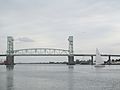
Bridges Over the Cape Fear
Many bridges cross the Cape Fear River, connecting different parts of North Carolina.
- Cape Fear Memorial Bridge (US 17/US 76/US 421)
- S. Thomas Rhodes Bridge (US 421/NC 133/US 74)
- Trooper Harry T. Long Bridge
- L. Bobby Brown Bridge (I-140)
River Health and Pollution
The Cape Fear River has the largest river basin in North Carolina, covering over 9,100 square miles. This large area means that water runoff from cities and farms can affect the river's water quality. The river can be impacted by different types of pollution.
Understanding Pollution Sources
Pollution can come from two main types of sources:
- Point source pollution comes from a single, identifiable place, like a pipe from a factory.
- Nonpoint source pollution comes from many spread-out sources, like runoff from farms or city streets. This runoff can carry harmful chemicals, fertilizers, and even soil particles into the river.
Suspended Solids in the Water
Suspended solids are tiny particles, both living and nonliving, that float in the water. They often enter rivers from nonpoint sources, like soil washing into the river during heavy rains. In 2018, a big storm called Hurricane Florence caused a dam to break. This led to a leakage of coal ash (a leftover material from burning coal) into the Cape Fear River near Wilmington, North Carolina. This event added many suspended solids to the river.
If you see a lot of floating dirt or murky water, you can report it here.
GenX Chemicals in the River
GenX is a man-made chemical that belongs to a group called PFAs. These chemicals are used to make things non-stick, water-repellent, and stain-resistant. GenX was created to replace older, more harmful PFAs.
How GenX Enters the River
GenX has entered the Cape Fear River from the wastewater of a chemical plant in Fayetteville, NC. Like other PFAs, GenX does not easily break down. This means it can stay in the environment for a long time and build up in living things.
Impacts on Water and Wildlife
Because GenX was in the river, it became a concern for people who use the Cape Fear River for drinking water, especially in the Fayetteville and Wilmington areas. Studies have also shown that GenX can affect wildlife. For example, it has been found in Striped Bass caught from the river and has impacted their health. In plants, GenX can reduce growth and build up inside the plant.
Learning More About GenX
Scientists are still learning about GenX. They are studying how it moves through soil and water and how it affects people and animals. There are no federal rules for GenX yet, but North Carolina has set a "health goal" for the chemical. This goal suggests a very low level of GenX that is not expected to cause health problems over time. Researchers are also looking for ways to remove GenX and other PFAs from contaminated water, using methods like special filters.
Images for kids
-
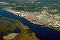
The port in Wilmington on the Cape Fear River estuary
-
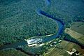
Lock and Dam No. 1 on the Cape Fear River in Bladen County
-
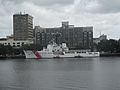
U.S. Coast Guard vessel on the Cape Fear, photographed from the USS North Carolina
-
A cargo ship navigating the mouth of the Cape Fear River at Southport
-

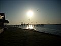
Sunset over the Cape Fear River flowing under the S. Thomas Rhodes Bridge.
-
Cape Fear Memorial Bridge in Wilmington is the highest in North Carolina.


See also
 In Spanish: Río Cape Fear para niños
