Erwin, North Carolina facts for kids
Quick facts for kids
Erwin, North Carolina
|
||
|---|---|---|

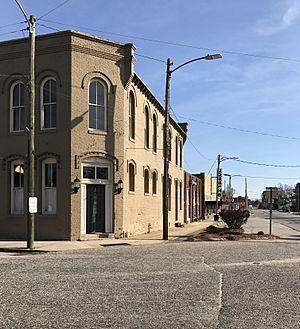
Downtown Erwin
|
||
|
||
| Motto(s):
"Front Porch Friends"
|
||

Location of Erwin, North Carolina
|
||
| Country | United States | |
| State | North Carolina | |
| County | Harnett | |
| Area | ||
| • Total | 4.25 sq mi (11.02 km2) | |
| • Land | 4.22 sq mi (10.92 km2) | |
| • Water | 0.04 sq mi (0.10 km2) | |
| Elevation | 194 ft (59 m) | |
| Population
(2020)
|
||
| • Total | 4,542 | |
| • Density | 1,077.32/sq mi (415.98/km2) | |
| Time zone | UTC-5 (Eastern (EST)) | |
| • Summer (DST) | UTC-4 (EDT) | |
| ZIP Code |
28339
|
|
| Area codes | 910, 472 | |
| FIPS code | 37-21740 | |
| GNIS feature ID | 2406460 | |
Erwin is a town in Harnett County, North Carolina, United States. It is about 5 miles (8 km) from Dunn and 20 miles (32 km) from Fayetteville. The town is part of a larger area that includes Raleigh, Durham, and Cary.
As of the 2020 United States census, Erwin has a population of 4,542 people. The current mayor is Randy Baker. He was elected on May 17, 2022.
Contents
History of Erwin
Before Erwin became a town, there was an older settlement called "Averasboro." A famous battle during the American Civil War called the Battle of Averasborough happened nearby.
In 1902, the Duke family built the Erwin Cotton Mill. This mill was a big part of the town's economy for many years. However, it closed on December 1, 2000. This happened because of a trade agreement called the North American Free Trade Agreement (NAFTA). This agreement made it more expensive to run the mill in the U.S., so the company moved its operations to Mexico.
The town was first named "Duke" after the people who started the mill. But in 1925, its name was changed to "Erwin." This change happened because Duke University was formed in Durham, North Carolina. Some important places in Erwin, like Oak Grove and the Averasboro Battlefield Historic District, are listed on the National Register of Historic Places. This means they are important historical sites.
Geography of Erwin
Erwin covers a total area of about 4.25 square miles (11.02 square kilometers). Most of this area is land, with a small part being water.
The Cape Fear River runs along part of the town's western edge. Juniper Creek also flows into the Cape Fear River in Erwin. A tributary is a smaller stream or river that flows into a larger one.
Transportation in Erwin
By Road
- US 421: This highway comes into Erwin from the northwest. It continues to Dunn, North Carolina, where it connects with Interstate 95, a major highway along the East Coast.
- NC 217: This shorter highway enters Erwin from the south. It ends in the northern part of the town, where it meets US 421.
- NC 82: This highway also comes from the south. It joins with NC 217 through the center of Erwin, on a street known as 13th Street. Both highways end at US 421 in the northern part of town.
By Air
- Harnett Regional Jetport: This is the only airport near Erwin. It is about 10 miles (16 km) from Buies Creek, North Carolina. Currently, no airlines fly from this airport.
- RDU Airport: While not in Erwin, Raleigh-Durham International Airport serves the larger Triangle area, which includes Erwin. Many people use this airport for travel.
Public Transit
Erwin does not have public transportation services like buses. However, carpool services such as Uber and Lyft are available in the town 24 hours a day, seven days a week.
Education in Erwin
Higher Education
- Campbell University
- Central Carolina Community College
Public Schools
High School
- Triton High School (North Carolina)
Middle School
- Coats-Erwin Middle
Elementary School
- Erwin Elementary: This school was formed by combining Erwin and Gentry elementary schools. The new Erwin Elementary opened on April 18, 2022.
Population Information
| Historical population | |||
|---|---|---|---|
| Census | Pop. | %± | |
| 1950 | 3,344 | — | |
| 1960 | 3,183 | −4.8% | |
| 1970 | 2,852 | −10.4% | |
| 1980 | 2,828 | −0.8% | |
| 1990 | 4,061 | 43.6% | |
| 2000 | 4,537 | 11.7% | |
| 2010 | 4,405 | −2.9% | |
| 2020 | 4,542 | 3.1% | |
| U.S. Decennial Census | |||
2020 Census Details
The 2020 United States census counted 4,542 people living in Erwin. There were 1,890 households and 1,254 families in the town.
The table below shows the different groups of people living in Erwin based on the 2020 census:
| Race | Number | Percentage |
|---|---|---|
| White (not Hispanic) | 2,900 | 63.85% |
| Black or African American (not Hispanic) | 794 | 17.48% |
| Native American | 28 | 0.62% |
| Asian | 9 | 0.2% |
| Pacific Islander | 6 | 0.13% |
| Other/Mixed | 193 | 4.25% |
| Hispanic or Latino | 612 | 13.47% |
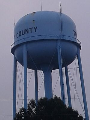
Erwin's Water Tower
In early 2012, Erwin became home to a very tall water tower. This tower is shaped like a sphere (a perfect ball) on top. It stands 219.75 feet (66.98 meters) tall. This makes it about 8 feet (2.4 meters) taller than the previous record holder, the Union Watersphere in Union, New Jersey.
Notable People from Erwin
- Al Woodall, a former professional American football quarterback who played in the National Football League (NFL).
See also
 In Spanish: Erwin (Carolina del Norte) para niños
 | Dorothy Vaughan |
 | Charles Henry Turner |
 | Hildrus Poindexter |
 | Henry Cecil McBay |


