Harnett County, North Carolina facts for kids
Quick facts for kids
Harnett County
|
|||||
|---|---|---|---|---|---|

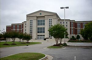
Harnett County Courthouse
|
|||||
|
|||||

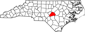
Location within the U.S. state of North Carolina
|
|||||
 North Carolina's location within the U.S. |
|||||
| Country | |||||
| State | |||||
| Founded | 1855 | ||||
| Named for | Cornelius Harnett | ||||
| Seat | Lillington | ||||
| Largest community | Anderson Creek | ||||
| Area | |||||
| • Total | 601.22 sq mi (1,557.2 km2) | ||||
| • Land | 594.93 sq mi (1,540.9 km2) | ||||
| • Water | 6.29 sq mi (16.3 km2) 1.05% | ||||
| Population
(2020)
|
|||||
| • Total | 133,568 | ||||
| • Estimate
(2023)
|
141,477 | ||||
| • Density | 224.51/sq mi (86.68/km2) | ||||
| Time zone | UTC−5 (Eastern) | ||||
| • Summer (DST) | UTC−4 (EDT) | ||||
| Congressional districts | 9th, 13th | ||||
Harnett County (/ˈhɑːrnɪt/ HAR-nit) is a county in North Carolina, a state in the United States. In 2020, about 133,568 people lived here. The main town and county seat is Lillington. The biggest community is Anderson Creek. Harnett County is part of the Anderson Creek area, which is a "Micropolitan Statistical Area." This means it's a smaller city area with close ties to nearby towns.
Contents
History of Harnett County
Harnett County was created in 1855. It was formed from land that used to be part of Cumberland County. The county is named after Cornelius Harnett. He was an important soldier in the American Revolutionary War. He also served as a delegate to the Continental Congress. This was a group of representatives from the American colonies who met to make decisions during the Revolution.
The first settlers arrived in this area around the 1720s. Later, many Highland Scots immigrants came. These Scots settled in the hilly areas because the land was cheaper there. This was different from the rich, flat land near the coast. More Scots came after their defeat in Scotland at the Battle of Culloden. They traveled up the Cape Fear River and settled in western Harnett County. British immigrants mostly settled along the Cape Fear River closer to the coast.
During the American Revolutionary War, many Scots were Loyalists. This meant they stayed loyal to the British King. They had made promises not to fight against the British. Some Rebels, who wanted independence, saw them as traitors. There were even public executions of people thought to be spies. One such event happened near Lillington, where many Scots were executed.
Harnett County did not see much fighting during the American Civil War. However, one of the last battles of the war happened nearby. This was the Battle of Averasborough. Averasborough was once a very large town in North Carolina, but it no longer exists. In this battle, part of General William Sherman's army defeated General William Hardee's army. This happened during the Carolinas Campaign. A celebration of this battle was held in 1965 at the battlefield site.
Geography of Harnett County
Harnett County covers about 601 square miles. Most of this area, about 595 square miles, is land. The rest, about 6 square miles, is water.
Parks and Protected Areas
- Anderson Creek County Park
- Averasboro Battlefield and Museum
- Harris Game Land (part)
- Raven Rock State Park
- Rhodes Pond Game Land (part)
Major Rivers and Creeks
- Black River
- Buies Creek
- Cape Fear River
- Cedar Creek
- East Buies Creek
- Little River
- Mingo Swamp
- Neills Creek
- Thorntons Creek
- Upper Little River
- West Buies Creek
Neighboring Counties
- Wake County – to the north
- Johnston County – to the northeast
- Sampson County – to the southeast
- Cumberland County – to the south
- Moore County – to the west-southwest
- Lee County – to the west-northwest
- Chatham County – to the northwest
Main Roads
 I-95
I-95


 Future I-685
 US 301
 US 401
 US 421
 NC 24
NC 24 NC 27
NC 27 NC 42
NC 42 NC 55
NC 55 NC 82
NC 82 NC 87
NC 87 NC 210
 NC 217
Important Facilities
- Fort Liberty (Linden Oaks)
- Harnett Regional Jetport
People of Harnett County
Population in 2020
| Group | Number | Percentage |
|---|---|---|
| White (not Hispanic) | 77,876 | 58.3% |
| Black or African American (not Hispanic) | 26,769 | 20.04% |
| Native American | 978 | 0.73% |
| Asian | 1,408 | 1.05% |
| Pacific Islander | 242 | 0.18% |
| Other/mixed | 7,396 | 5.54% |
| Hispanic or Latino | 18,899 | 14.15% |
In 2020, 133,568 people lived in Harnett County. This made it the 23rd most populated county in North Carolina. Anderson Creek was the largest community at that time.
How the Population Changed
| Historical population | ||||||||||||||||||||||||||||||||||||||||||||||||||||||||||||||||||||||||||||||||||||
|
||||||||||||||||||||||||||||||||||||||||||||||||||||||||||||||||||||||||||||||||||||
Between 2010 and 2020, Harnett County's population grew quite a lot. It increased by 18,890 people, which is an 18.6 percent jump. Even though the county grew, the town of Dunn actually got smaller. The percentage of white residents went down a little. Meanwhile, the percentage of Hispanic/Latino people grew. The Asian population also saw a small increase. The number of Black and Native American residents stayed about the same.
Education in Harnett County
Harnett County is home to Campbell University. It also has 27 other schools for younger students. These include 4 primary schools, 13 elementary schools, 5 middle schools, 4 high schools, and 1 alternative school.
Harnett County Schools is the public school system for the area.
Here are some of the schools in the county:
- Primary Schools: Anderson Creek, Gentry, Harnett, North Harnett
- Elementary Schools: Angier, Benhaven, Boone Trail, Buies Creek, Coats, Erwin, Highland, Johnsonville, LaFayette, Lillington-Shawtown, Overhills, South Harnett, Wayne Avenue
- Middle Schools: Coats-Erwin, Dunn, Harnett Central, Highland, Overhills, Western Harnett
- High Schools: Harnett Central, Overhills, Triton, Western Harnett
- Alternative School: STAR Academy (for grades 6–12)
- University: Campbell University
Some students living in the Linden Oaks area, near Fort Liberty, attend special schools. These are called Department of Defense Education Activity (DoDEA) schools. They include Gary Ivan Gordon Elementary School and Randall David Shughart Elementary School. There is also Shugart Middle School. High school students from Linden Oaks go to Overhills High School, which is part of Harnett County Schools.
The county also has a library system. The main library is in Lillington. There are branches in Angier, Coats, Dunn, and Erwin. There are also libraries at Anderson Creek Primary School and the Boone Trail Community Center.
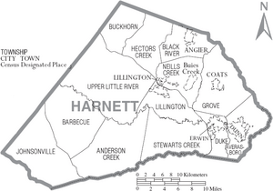
Communities in Harnett County
Cities
Towns
- Angier (most of it)
- Coats
- Erwin
- Lillington (the county seat)
- Fuquay-Varina (part of it)
Census-Designated Places (CDPs)
These are areas that are like towns but are not officially incorporated.
- Anderson Creek (the largest community)
- Buies Creek
- Bunnlevel
- Mamers
- Spout Springs
Townships
These are smaller divisions of the county.
- Anderson Creek
- Averasboro
- Barbecue
- Black River
- Buckhorn
- Duke
- Grove
- Hectors Creek
- Johnsonville
- Lillington
- Neills Creek
- Stewarts Creek
- Upper Little River
Other Unincorporated Communities
These are small places that are not part of any city or town.
- Barbecue
- Barclaysville
- Cape Fear
- Chalybeate Springs
- Christian Light
- Cokesbury
- Duncan
- Flat Branch
- Flatwoods
- Johnsonville
- Kipling
- Luart
- Olivia
- Overhills
- Pineview
- Rawls
- Ryes
- Seminole
- Shawtown
- Turlington
- Raven Rock
- Norrington
- Mount Pisgah
See also
 In Spanish: Condado de Harnett para niños
 | James Van Der Zee |
 | Alma Thomas |
 | Ellis Wilson |
 | Margaret Taylor-Burroughs |


