Johnston County, North Carolina facts for kids
Quick facts for kids
Johnston County
|
|||||
|---|---|---|---|---|---|
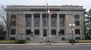
Johnston County Courthouse
|
|||||
|
|||||
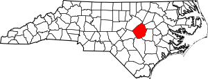
Location within the U.S. state of North Carolina
|
|||||
 North Carolina's location within the U.S. |
|||||
| Country | |||||
| State | |||||
| Established | June 28, 1746 | ||||
| Named for | Gabriel Johnston | ||||
| Seat | Smithfield | ||||
| Largest community | Clayton | ||||
| Area | |||||
| • Total | 795.65 sq mi (2,060.7 km2) | ||||
| • Land | 792.02 sq mi (2,051.3 km2) | ||||
| • Water | 3.63 sq mi (9.4 km2) 0.46% | ||||
| Population
(2020)
|
|||||
| • Total | 215,999 | ||||
| • Estimate
(2023)
|
241,955 | ||||
| • Density | 272.72/sq mi (105.30/km2) | ||||
| Time zone | UTC−5 (Eastern) | ||||
| • Summer (DST) | UTC−4 (EDT) | ||||
| ZIP Codes |
27501, 27504, 27520, 27524, 27527, 27529, 27542, 27555, 27557, 27568, 27569, 27576, 27577, 27591, 27592, 27597, 27603, 28334, 28366
|
||||
| Area code | 919, 984 | ||||
| Congressional district | 13th | ||||
Johnston County is a county in the state of North Carolina, USA. In 2020, about 215,999 people lived here. The main town, or county seat, is Smithfield.
Johnston County is part of a larger area called the Raleigh-Cary Metropolitan Statistical Area. This bigger area is also part of the Raleigh-Durham-Cary Combined Statistical Area. In 2023, this entire area had an estimated population of over 2.3 million people.
Contents
History of Johnston County
Johnston County was created on June 28, 1746. It was formed from the northern part of Craven County. Over the years, parts of Johnston County were used to create other nearby counties.
For example, in 1752, parts of Johnston, Granville, and Bladen counties became Orange County. Later, in 1770, parts of Johnston, Cumberland, and Orange counties formed Wake County. Finally, in 1855, parts of Johnston and other counties were used to create Wilson County.
Early Farming and Growth
Many early settlers in Johnston County were subsistence farmers. This means they grew just enough food for their families. Some farmers also grew tobacco as a cash crop. A cash crop is something grown to be sold for money. They also raised pigs and cattle to sell in Virginia.
Smithfield became an important place because it was the furthest west that boats could travel on the Neuse River. In 1770, a special warehouse was built there to store tobacco before it was shipped out.
Around 1804, the cotton gin was brought to the county. This machine made it much easier to separate cotton fibers from their seeds. Because of this, cotton became the most important cash crop in the area.
Transportation and New Towns
For a long time, it was hard to sell crops from Johnston County because transportation was poor. But in 1856, the North Carolina Railroad was finished. This connected Johnston County to bigger cities.
With better transportation, farming for sale grew a lot. Industries like lumber and turpentine also started. New towns like Princeton, Pine Level, Selma, and Clayton were created because of this growth.
Civil War and Changes
About 1,500 men from Johnston County fought in the American Civil War. Sadly, about a third of them died. After the war, there were many changes. Slavery ended, which caused big social and economic shifts.
In 1868, a new state constitution created the county's first townships. These are smaller local government areas. More changes to these townships happened until 1913. In 1886, a new railroad line called the "Short-Cut" was built through Johnston County. This led to the creation of towns like Kenly, Micro, Four Oaks, and Benson.
Economic Ups and Downs
In 1893, there was an economic problem called the Panic of 1893. This caused cotton prices to drop sharply. So, farmers in the area started growing bright leaf tobacco as their main cash crop instead.
A new tobacco market opened in Smithfield in 1898. The county's first bank was also created around this time. Soon after, cotton mills were built in Smithfield, Clayton, and Selma.
During World War I, tobacco and cotton prices went up for a short time. This made the local economy boom. The county used this money to build new schools and combine all public schools into one system.
In the 1920s, the state built the county's first two paved highways. Many towns then started paving their main streets. While businesses did well, farmers struggled because tobacco and cotton prices fell again. The Wall Street Crash of 1929 and the Great Depression that followed caused all the banks in the county to close. After 1949, most roads and town streets in the county were paved.
Why the Name Johnston?
Johnston County was named after Gabriel Johnston. He was the Governor of North Carolina when the county was created in 1746.
Geography of Johnston County
Johnston County covers a total area of about 795.65 square miles. Most of this (about 792.02 square miles) is land. A small part (about 3.63 square miles) is water.
Protected Natural Areas
Johnston County has several protected natural areas where you can explore and learn:
- Bentonville Battlefield State Historic Site
- Clemmons Educational State Forest (part of it)
- Flower Hill Nature Preserve (part of it)
- Howell Woods Environmental Learning Center
- Wild Bills Western Town - Shadowhawk
Major Waterways
The county has many important rivers and creeks:
- Black Creek
- Buckhorn Reservoir
- Buffalo Creek
- Hannahs Creek
- Holts Lake
- Little Creek
- Little River
- Middle Creek
- Mingo Swamp
- Mill Creek
- Moccasin Creek
- Neuse River
- Sassarixa Swamp
- Snipers Creek
- Swift Creek
Neighboring Counties
Johnston County shares borders with these counties:
- Wake County – to the northwest
- Franklin County – to the north
- Nash County – to the northeast
- Wilson County – to the east
- Wayne County – to the southeast
- Sampson County – to the south
- Harnett County – to the southwest
Main Roads and Transportation
Many important highways run through Johnston County, connecting it to other parts of North Carolina and beyond.
 I-40
I-40


 I-42 / Future I-42
 I-95
I-95


 I-540 / NC 540 Toll


 Future I-587
 US 70
US 70
 US 70 Alt.
 US 70 Bus.
 US 264


 US 264 Alt.
 US 301
 US 701
 NC 27
NC 27 NC 39
NC 39 NC 42
NC 42 NC 50
NC 50 NC 55
NC 55 NC 96
NC 96 NC 210
 NC 222
 NC 231
 NC 242
The county also has:
- Johnston Regional Airport
- Selma Union Depot (a train station)
People of Johnston County
The population of Johnston County has grown a lot over the years. Here's how it has changed:
| Historical population | |||
|---|---|---|---|
| Census | Pop. | %± | |
| 1790 | 5,691 | — | |
| 1800 | 6,301 | 10.7% | |
| 1810 | 6,867 | 9.0% | |
| 1820 | 9,607 | 39.9% | |
| 1830 | 10,938 | 13.9% | |
| 1840 | 10,599 | −3.1% | |
| 1850 | 13,726 | 29.5% | |
| 1860 | 15,656 | 14.1% | |
| 1870 | 16,897 | 7.9% | |
| 1880 | 23,461 | 38.8% | |
| 1890 | 27,239 | 16.1% | |
| 1900 | 32,250 | 18.4% | |
| 1910 | 41,401 | 28.4% | |
| 1920 | 48,998 | 18.3% | |
| 1930 | 57,621 | 17.6% | |
| 1940 | 63,798 | 10.7% | |
| 1950 | 65,906 | 3.3% | |
| 1960 | 62,936 | −4.5% | |
| 1970 | 61,737 | −1.9% | |
| 1980 | 70,599 | 14.4% | |
| 1990 | 81,306 | 15.2% | |
| 2000 | 121,965 | 50.0% | |
| 2010 | 168,878 | 38.5% | |
| 2020 | 215,999 | 27.9% | |
| 2023 (est.) | 241,955 | 43.3% | |
| U.S. Decennial Census 1790–1960 1900–1990 1990–2000 2010 2020 |
|||
Population in 2020
In 2020, there were 215,999 people living in Johnston County. These people lived in about 73,567 households, with 53,743 being families.
Here's a look at the different groups of people living in Johnston County in 2020:
| Race | Number | Percentage |
|---|---|---|
| White (non-Hispanic) | 136,464 | 63.18% |
| Black or African American (non-Hispanic) | 33,041 | 15.3% |
| Native American | 880 | 0.41% |
| Asian | 1,831 | 0.85% |
| Pacific Islander | 71 | 0.03% |
| Other/Mixed | 9,312 | 4.31% |
| Hispanic or Latino | 34,400 | 15.93% |
Education in Johnston County
Johnston County offers many educational opportunities for students of all ages.
Colleges and Universities
Johnston Community College (JCC) is located in Smithfield. It's a public college where students can earn a two-year degree. JCC also has learning centers in other parts of Johnston County.
Schools for Kids (K-12)
The Johnston County School District manages all public schools from kindergarten to 12th grade. The district has 46 schools and teaches over 35,400 students. There are also three charter schools and five private schools in the county.
Libraries
The Johnston County Public Affiliated Library system has six branches. These libraries offer books, magazines, audiobooks, and even e-books you can download. The Hocutt-Ellington Memorial Library in Clayton became independent from the county system in 2015.
Culture and Fun in Johnston County
Johnston County has many interesting places and events that celebrate its history and culture.
Historical Sites
- The Bentonville Battlefield State Historic Site is the largest Civil War battlefield in North Carolina. The Battle of Bentonville happened here in 1865. It was the only time the Confederate army tried to stop General Sherman's famous march through the South.
- The Tobacco Farm Life Museum in Kenly shows what life was like for farmers in Eastern North Carolina for over 35 years. It has a museum, a restored farm, a blacksmith shop, and a one-room schoolhouse.
- The Johnston County Heritage Centers in Smithfield keep old county items and family history records.
Arts and Entertainment
- The Ava Gardner Museum, located in Smithfield, has a collection of items from actress Ava Gardner. She was born and grew up in Johnston County. The museum has her scripts, movie posters, costumes, and personal things. They also have an annual festival to celebrate her life.
- The Johnston County Arts Council helps promote art in the county and its schools.
- The Meadow community is home to Meadow Lights. This is a popular annual display of amazing Christmas lights.
Media in Johnston County
Johnston County has its own radio stations, TV channels, and newspapers.
Radio and Television
Johnston County is part of the Raleigh-Durham radio market. This is one of the largest radio markets in the United States.
- The county's first radio station was WMPM, 1270 AM, in Smithfield, which started in 1950.
- Other local radio stations include WPYB, 1130 AM in Benson, WHPY, 1590 AM in Clayton, WTSB, 1090 AM in Selma, and WKJO, 102.3 FM in Smithfield.
The county is also part of the Raleigh-Durham-Fayetteville TV market.
- WNGT-CD, a low-power TV station, is licensed to Smithfield and Selma. It shares a frequency with Raleigh's WRAL-TV, which helps it reach more viewers.
- Goldsboro-licensed CBS channel WNCN (channel 17) originally started in Clayton in 1988 before moving to Raleigh in 1995.
Newspapers
There are many local newspapers that keep the people of Johnston County informed:
- Clayton News-Star
- Kenly News
- Four Oaks-Benson News in Review
- Princeton News Leader
- The Selma News
- Pine Level News
- Johnstonian News
- The Daily Record
- The Smithfield Herald
- The Cleveland Post
- The Garner-Cleveland Record
- The News & Observer
Communities in Johnston County
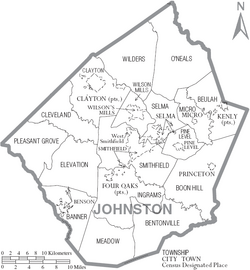
Johnston County has many different towns and communities.
Towns
These are the main towns in Johnston County:
- Archer Lodge
- Benson
- Clayton (This is the largest community in the county)
- Four Oaks
- Kenly
- Micro
- Pine Level
- Princeton
- Selma
- Smithfield (This is the county seat, where the main government offices are)
- Wilson's Mills
Townships
Townships are smaller areas within the county, often used for local government or land division:
- Banner
- Bentonville
- Beulah
- Boon Hill
- Brogden
- Clayton
- Cleveland
- Elevation
- Ingrams
- Meadow
- Micro
- O'Neals
- Pine Level
- Pleasant Grove
- Selma
- Smithfield
- Wilders
- Wilson Mills
Unincorporated Communities
These are smaller communities that are not officially part of a town or city:
- Allens Crossroads
- Bagley
- Blackmans Crossroads
- Cleveland
- Emit
- Flowers
- Grabtown
- Hocutts Crossroads
- Jordan
- McGee's Crossroads
- Peacocks Crossroads
- Powhatan
- Spilona
- Stancils Chapel
- West Smithfield
- Willow Spring (part)
See also
 In Spanish: Condado de Johnston (Carolina del Norte) para niños
 | Delilah Pierce |
 | Gordon Parks |
 | Augusta Savage |
 | Charles Ethan Porter |


